Hiking the Waʻahila Ridge Trail to Mt. Olympus (ʻAwaʻawaloa) on Oʻahu, Hawaiʻi
Distance: 5.6 miles / 9.0 km
The Waʻahila Ridge Trail in the southern Koʻolau Mountains on Oʻahu is one of my favorite ridge hikes on the town side of the island, and in my opinion, it’s one of the best day hikes near Waikīkī!
I say this for a few reasons. The first is that Waʻahila Ridge is a very well-trafficked trail, meaning the overgrowth is much less noticeable and, in most cases, not an issue compared to other Oʻahu ridge hikes, like the nearby Wailupe Loop Trail. However, what’s perhaps even more important is that from the summit, there are amazing views of Kaʻau Crater to the east, which is one of my favorite ways to enjoy the beautiful crater without doing the longer and more involved Kaʻau Crater Trail from Pālolo Valley.
Waʻahila Ridge Trailhead Parking
Parking for the Waʻahila Ridge Trail is located at the very top of St. Louis Heights in the Waʻahila Ridge State Recreation Area.
Out of caution, consider the Waʻahila Ridge Trailhead to be a high-crime area for petty theft, meaning you should never leave visible bags or anything valuable in your car.
Google Maps Directions: Waʻahila Ridge State Recreation Area
Hiking the Waʻahila Ridge Trail
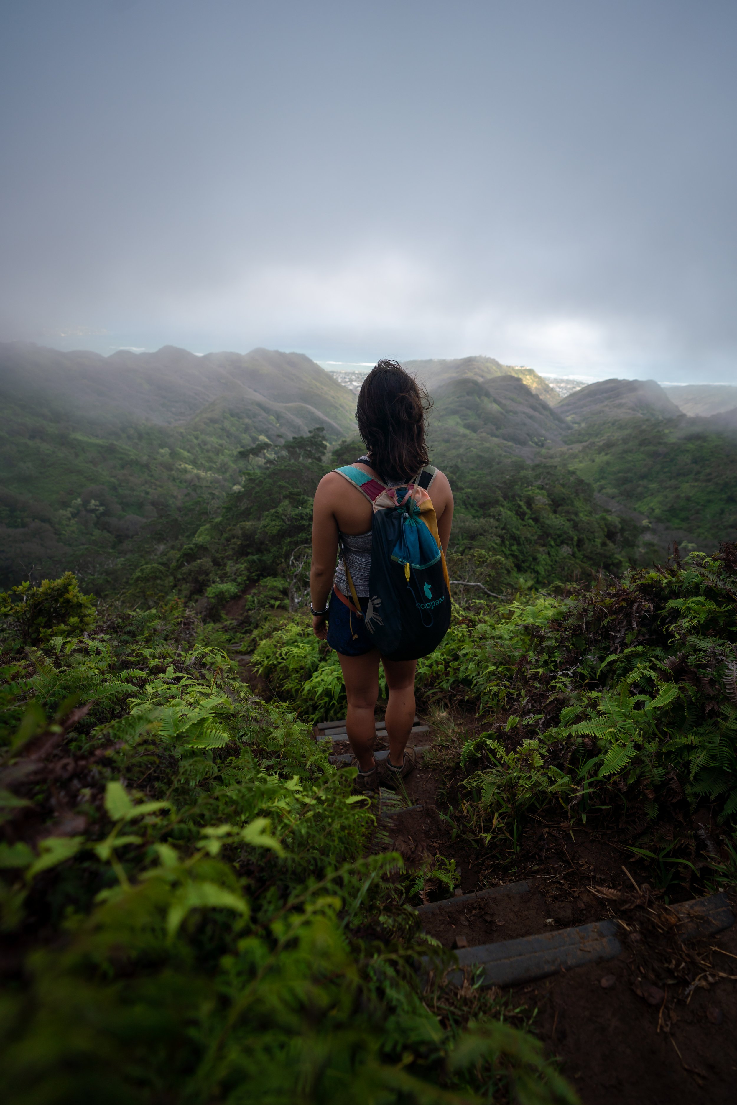
The Waʻahila Ridge Trail begins within the beautiful Cook Pine forest at the very top of the parking lot in Waʻahila State Recreation Area and extends for roughly 2.8 miles (4.5 km) to the Koʻolau Summit atop Mt. Olympus.
This water tank is always a nice sign that you’re nearing the trailhead at the end of the long return hike.
After roughly 0.3 miles (0.5 km), the Waʻahila Ridge Trail makes a hard left turn off the ridgeline.
Once the Waʻahila Ridge Trail regains the ridge, the trail begins to traverse a number of rolling hills before the steeper, more significant drops shortly ahead.
Through these beginning sections, ʻUhaloa, ʻIlima, and ʻIeʻie are the three most prominent native plants that can be found along Waʻahila Ridge.
At about 0.5 miles (0.8 km), the trail reaches the start of the biggest descent on Waʻahila Ridge—one that will inevitably have to be re-climbed on the hike out.
At these steep ledges, there’s always an easy workaround, as opposed to going straight over.
Shortly past the first descent, Waʻahila Ridge comes to this second and much steeper drop.
About halfway down the second descent, the Waʻahila Ridge Trail reaches a near-vertical drop.
However, there is an easier route on the right-hand side of the ridge that makes for a better place to scramble around this section.
Following the steep descent shown above, the Waʻahila Ridge Trail will come to this split.
Here, go right to stay on the correct trail, as the path to the left isn’t better or more direct. Rather, it’s more overgrown until it eventually returns back to the correct trail when both sides meet again.
For those who may be interested, trail running the first 1.5 miles (2.4 km) to the Kolowalu junction is popular among locals—especially in the evening, when the golden light begins to shine across these southern Koʻolau ridges!
That said, these are my preferred trail-running shoes, which not only work great on Waʻahila Ridge and others like the ʻAiea Loop Trail, but they are also my go-to hiking shoes for much less overgrown trails outside of Hawaiʻi.
This viewpoint of Mānoa Valley, at roughly 1.4 miles (2.3 km) from the trailhead, is one of the most popular turnaround points on Waʻahila Ridge prior to Pūkele Hill and the Kolowalu junction.
Waʻahila Ridge-Kolowalu Junction
At roughly 1.5 miles (2.4 km), the Waʻahila Ridge Trail splits with the Kolowalu Trail that connects Waʻahila with the Puʻu Pia Trail at the bottom of Mānoa Valley.
That said, it typically wouldn’t make sense to hike Kolowalu from Waʻahila Ridge unless you had planned to create a loop with the Mānoa Middle Ridge and the KST.
In any case, go right at this split to continue up Waʻahila Ridge to the Koʻolau Summit and Mt. Olympus.
Read My Separate Post:Kolowalu Trail
After the Kolowalu junction, the Waʻahila Ridge Trail continues through a mixed Strawberry Guava-Koa-ʻŌhiʻa forest before the ridge begins two separate steep climbs just below Pūkele Hill.
Moa is always a cool but a not-so-obvious native find in Hawaiʻi’s forests!
This is the first of the two steep climbs before Pūkele Hill.
While ropes on popular hikes like Waʻahila Ridge get replaced much more often than other Oʻahu trails, it’s never a bad idea to carry your own.
This little peak on the ridgeline is Pūkele Hill, the second-most popular turnaround point on the Waʻahila Ridge Trail.
When the trail comes to this steep drop, there’s either the option scoot straight off the ledge or make a hard right down the easier path around it.
There’s no shortage of steep descents on Waʻahila Ridge!
This is the bottom of the second and final steep ascent before Pūkele Hill.
Pūkele Hill
Pūkele Hill is the largest grassy clearing on the Waʻahila Ridge Trail, and the viewpoint to the south toward Mānoa Valley is, without a doubt, one of the best sunset spots on Oʻahu!
However, I only recommend catching the sunset this high up Waʻahila Ridge for confident, skilled hikers who are comfortable with the roughly 1.8-mile (2.9 km) hike back in the dark—which is all to say, carry a good headlamp and park outside of the State Recreation Area for such an adventure!
As Waʻahila Ridge moves higher, the trail becomes slightly more overgrown, as the majority of hikers turn around at Pūkele Hill prior to the summit.
Now, Waʻahila Ridge has nowhere near the same overgrowth as other southern Koʻolau ridges, like Kūlepeamoa Ridge, but even so, some hikers may still prefer to wear pants for the overgrowth, as well as the mud, which is fairly unavoidable below the summit.
The pants below are my recommendations that hold up the best with the overgrowth here in Hawaiʻi, but with any hiking pants that need to be durable, make sure that they are at or near 100% nylon. This is really the most important factor!
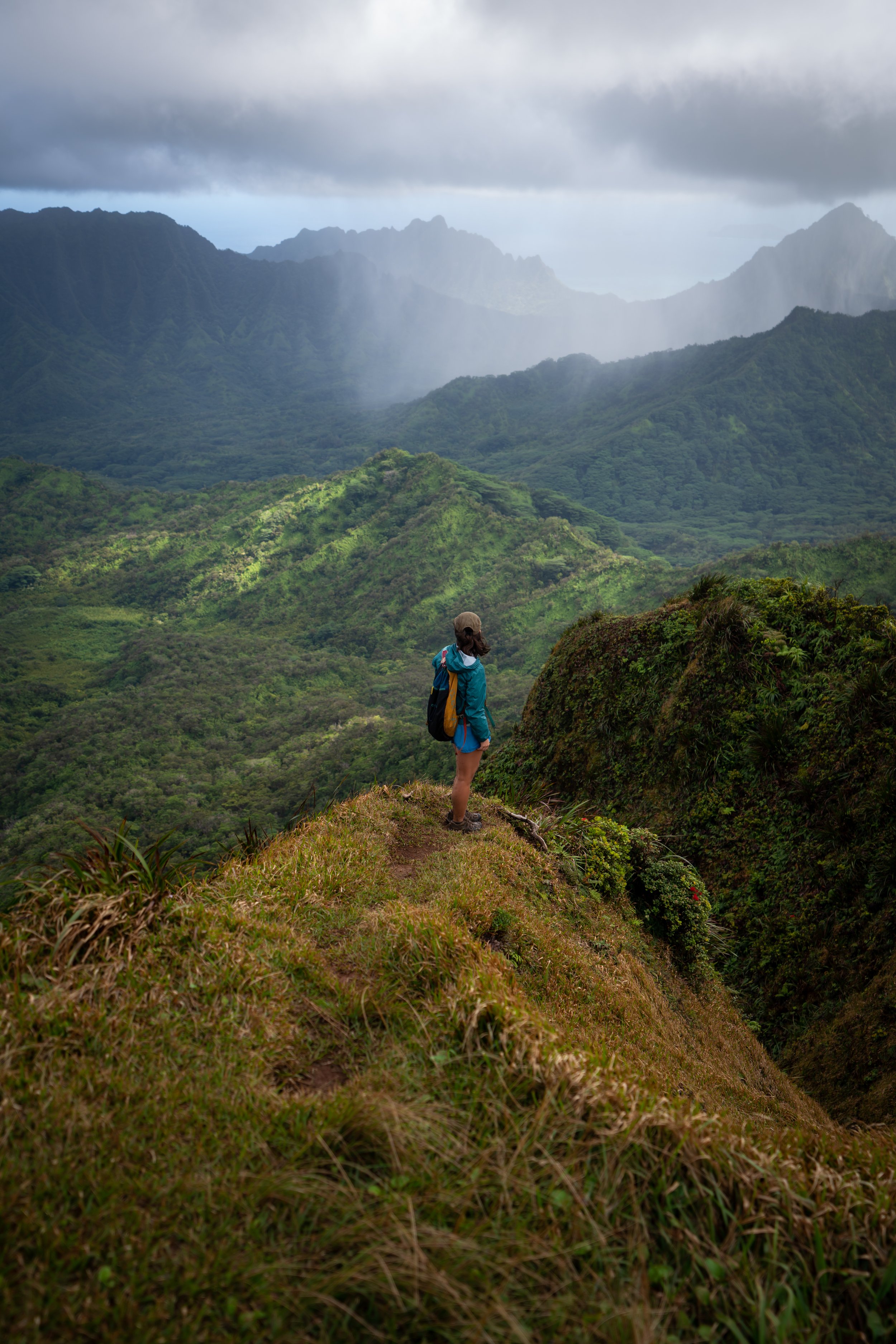
Mt. Olympus, also called ʻAwaʻawaloa, is the peak in the center of the photo below.
When Waʻahila Ridge leaves the Strawberry Guava forest behind on the uppermost elevations, the trail becomes much more exposed, which is why I recommend hiking in a hooded sun shirt.
From this viewpoint, the final two steep ascents leading up to Mt. Olympus can best be seen.
This is the first peak on the ridgeline, and the final peak (Mt. Olympus), furthest in the distance.
This is the bottom of the first ascent, which is the longest of the two.
It must be said that the erosion leading up to the summit is quite severe on Waʻahila Ridge, and I mention this to ask everyone to do your part to minimize your impact.
This clearing marks the top of the long first ascent and the bottom of the second.
That said, the second steep climb up to the summit is undoubtedly the most challenging, given the severity of the erosion shortly ahead.
At this point, Kaʻau Crater to the southeast, along with other notable summits like Wiliwilinui, becomes more and more visible on the uppermost elevations of Waʻahila.
This erosion on the Waʻahila Ridge Trail, prior to the Koʻolau Summit, is more significant here than in any other part of the hike, which can be especially challenging if the trail is wet.
Again, consider carrying your own ropes if you want the best assurance for everyone in your party.
Koʻolau Summit Trail (KST)
At the top of the steepest and most eroded ascent, the Waʻahila Ridge Trail reaches the flat spot shown in the photos below.
This is where Waʻahila Ridge meets the Koʻolau Summit Trail (KST), but this is not the summit of Mt. Olympus. Rather, the true summit follows the KST for roughly 0.1 miles (0.2 km) up the ridgeline to the south (right) to reach ʻAwaʻawaloa.
Mt. Olympus (ʻAwaʻawaloa) is the next closest peak to the south of Waʻahila Ridge.
Mt. Olympus (ʻAwaʻawaloa)
The end of the Waʻahila Ridge Trail is the prominent summit of ʻAwaʻawaloa, more commonly known as Mt. Olympus.
I say "prominent" because, on a clear day, Mt. Olympus stands above all the surrounding peaks and can be seen from as far away as Waikīkī and Kailua on the east side of Oʻahu.
Some notable places visible from the top include Kōnāhuanui to the north, the Lanikai Pillbox Trail and Kaʻau Crater to the east, as well as more distant locations such as Koko Head when looking south down the Koʻolau Mountains.
Koʻolau Summit Trail (KST)
Just past the summit, there is a beautiful open area to enjoy the views of Kaʻau Crater.
On a different note, don’t hike on the KST past Mt. Olympus unless you know exactly what you’re getting into.
The decent off of Mt. Olympus is very steep and exposed, and after this steep drop down a few hundred feet, the overgrowth picks up significantly until you reach the west rim of the Kaʻau Crater.
In the other direction, the next best trail is the Mānoa Middle Ridge, but even still, I only suggest traversing the summit to hikers who are familiar with what’s to come and the trails that descend back down.
Read My Separate Post: Koʻolau Summit Trail (KST)
Native Plants on Waʻahila Ridge
On the first mile up Waʻahila Ridge, native Hawaiian plants include ʻIlima, ʻUhaloa, ʻIeʻie, Palaʻā, and sometimes an occasional ʻŌhiʻa tree. However, like most Hawaiʻi hikes, the lower elevations of Waʻahila Ridge are dominated by non-native, invasive species such as Cook Pine, Strawberry Guava, Christmas Berry, and Palm Grass, to name just a few.
Nevertheless, once Waʻahila Ridge ascends to the upper elevations, there are countless native plants to look out for, including ʻĀkia, Alani, Kāwaʻu, Kōlea, ʻŌhiʻa lehua, Koa, Uluhe, and ʻŌhiʻa ha—to truly name only a few.
If you would like to learn more about these and many other native Hawaiian plants from across the islands, I encourage you to check out my separate post linked below.
Read My Separate Post: Native Hawaiian Plant Guide