Hiking the Lanikai Pillbox Trail (Kaʻiwa Ridge) on Oʻahu, Hawaiʻi
Distance (Roundtrip): 0.9 miles / 1.4 km
The Lanikai Pillbox Trail on the east side of Oʻahu is a local and visitor favorite, as the short hike, which climbs to two WWII-era pillboxes at the top, is without a doubt one of the best sunrise hikes on Oʻahu and one of the best day hikes on the island because of the stunning turquoise-blue water that can be seen just offshore on a clear day!
This is all to say that the effort-to-reward to reach the top of the Lanikai Pillbox Trail speaks for itself, given how short the hike is—at only 0.45 miles (0.7 km) each way—making the trail one of the best things to do on Oʻahu, especially early and late in the day!
Now, I can’t talk about the Lanikai Pillbox Trail without addressing the challenges of simply accessing the trail. By this, I mean that it’s a shame what the residents of Lanikai have done to make parking within the neighborhood nearly impossible for both the trail and Lanikai Beach, which is why I highly recommend reading through the following section in detail if you plan on driving to the Lanikai Pillbox hike.
Lanikai Pillbox Trailhead Parking
The Lanikai Pillbox Trail is the single most difficult hike to find parking for on Oʻahu, and currently, the parking situation is undergoing changes.
In July of 2025, the City and County of Honolulu announced a plan that will ban all parking on both ʻAʻalapapa and Mokulua Drive (the main one-way loop through Lanikai), and on the cross streets, from 10 a.m. to 4 p.m.
As of today, the newest announcements have suggested the changes will take effect in late 2026, but an official date from city officials has not yet been made known to the public. That said, please read the signs carefully whenever and wherever you decide to park in Lanikai.
What Do I Recommend?
Currently, even before these new rules take effect, my first sentiment is still true: the neighborhood is an incredibly difficult place to find a legal place to park, and this will only get more challenging when these changes are implemented.
I stress this because there are countless niche parking laws that have to do with how far away you can park from bike lanes, driveways, intersections, fire hydrants, and sidewalks, and to make matters worse, the City and County of Honolulu considers many unmarked places along the streets in Lanikai to be 'unimproved sidewalks,' meaning what may look like a perfectly fine spot to park off the street is actually a 'sidewalk,' making it illegal to park.
While I can’t help much with the unimproved sidewalk rule, know that tickets are handed out daily to anyone breaking any one of the following parking laws:
Driveways – No parking within 4 ft. (1.2 m)
Intersections – No parking within 20 ft. (6.1 m)
Fire Hydrants – No parking within 10 ft. (3 m)
Sidewalks, Crosswalks, & Bike Lanes – No parking or blocking in any way
There is honestly not another trail on Oʻahu that I would go into this much detail over, but in Lanikai, it really does matter!
For all these reasons, I personally recommend either arriving early to hike the trail for sunrise or parking outside of the Lanikai neighborhood—perhaps at Kailua Beach Park—to walk in, take the bus, or take an Uber to the trailhead.
I say this because, while you can try to arrive midday for the hike, parking will likely be very hard to come by, as the limited availability within Lanikai serves both the hike and the beach—not to mention the local residents.
Google Maps Directions: Lanikai Pillbox Trailhead
Hiking the Lanikai Pillbox Trail
The Lanikai Pillbox Trail begins near the upper end of Kaʻelepulu Drive, just before the gate for the private community at the end of the street.
I can confidently say that this warning is written with good intentions.
I believe this because rescues on trails across Oʻahu are seemingly a daily occurrence, as out-of-state residents don’t take hiking in Hawaiʻi seriously.
Furthermore, the Lanikai Pillbox Trail is a very steep, hot, and dry trail, and its short 0.45-mile (0.7 km) one-way distance should not be used to determine its difficulty.
It doesn’t take long for the Lanikai Pillbox Trail to begin climbing, as it’s nearly an all-uphill hike, ascending just over 400 ft. (122 m) from the trailhead to the Upper Pillbox—the highest pillbox on the hike.
That said, some hikers may want to bring trekking poles, as the steep, dry, loose trail is more challenging than it may seem in these photos.
When the Lanikai Pillbox Trail nears the upper end of the fence, the trail will braid out in all directions, but there should be one central path that is easiest to follow.
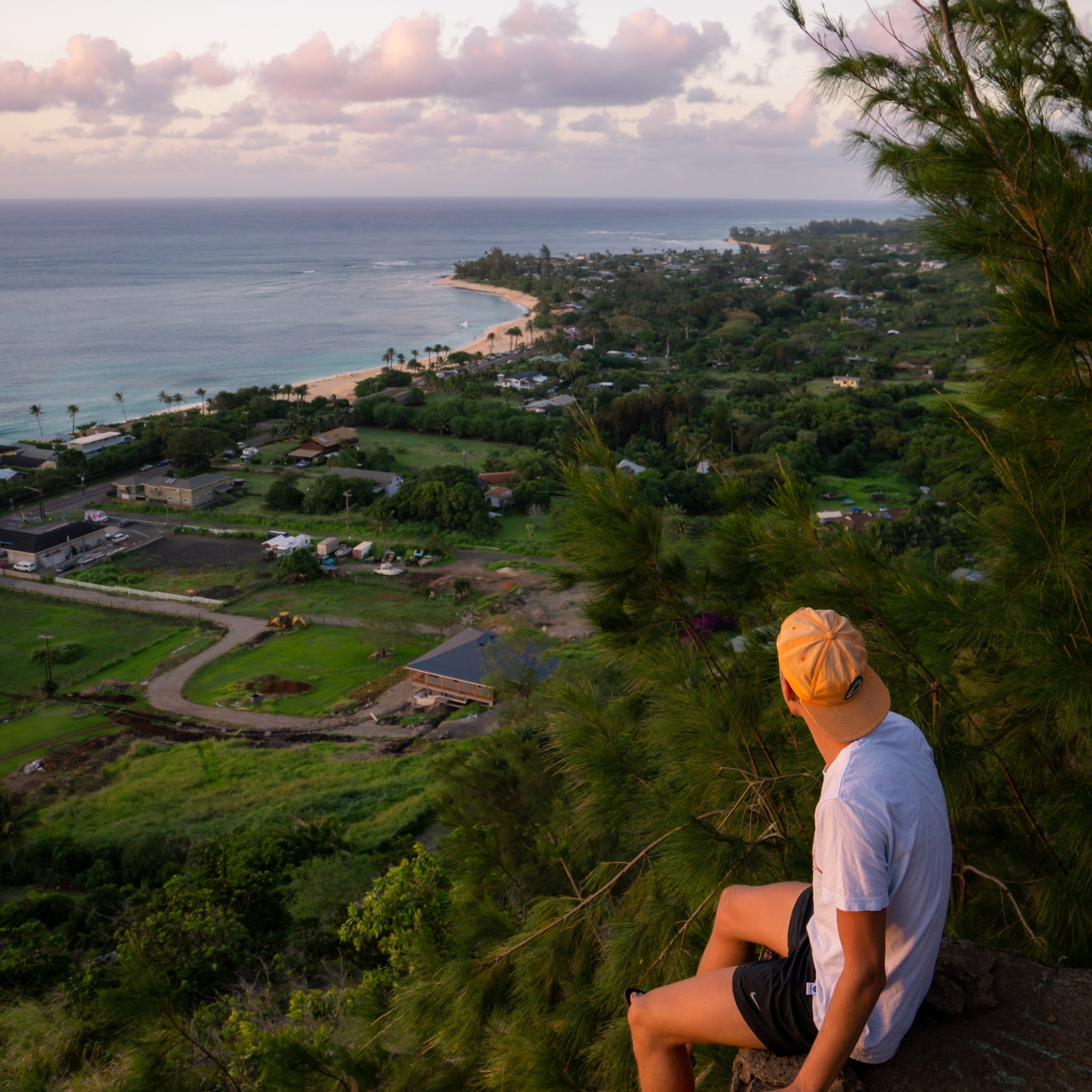
From this first flatter area on Kaʻiwa Ridge, the Lower Lanikai Pillbox can be seen in the distance!
As I’m sure is obvious, there is very little shade on Kaʻiwa Ridge, which is why I highly recommend hiking with a hooded sun shirt to stay safe, as one can be useful here and on countless other adventures across Hawaiʻi.
Again, some hikers may want to carry trekking poles for the steep and slippery hike—and yes, I do want to stress slippery, as the dry, loose soil has, unfortunately, been the culprit in fatal accidents on the Lanikai Pillbox Trail in the past.
When hiking up, know that the Upper Pillbox cannot be seen for the vast majority of the hike, as it doesn’t truly become visible until you reach the Lower Pillbox.
Just below the Lower Pillbox, the Lanikai Pillbox Trail will split, with both routes leading up the steep section just ahead.
However, the path to the left is a easier in my opinion, which is the route shown below, as the path to the right climbs a much steeper route up the cliff face ahead.
This is the steepest, and often considered the most challenging, part of the Lanikai Pillbox Trail.
Lower Lanikai Pillbox
After a very steep 0.3-mile (0.5 km) ascent, the Lanikai Pillbox Trail reaches the lower of the two WWII-era pillboxes, with the Upper Pillbox located roughly 0.1 miles (0.2 km) up the ridge from this point.
After the first bunker, the Kaʻiwa Ridge Trail simply continues up the ridgeline to the Upper Pillbox.
This short 0.1-mile (0.2 km) section between the two Lanikai Pillboxes is significantly easier and less steep than everything leading up to the Lower Pillbox.
Upper Lanikai Pillbox
This is the Upper Lanikai Pillbox, which looks directly out toward Lanikai Beach and the Mokulua Islands just offshore.
That said, if you are interested in visiting the two beautiful islands just offshore, I recommend reading the next section below, as planning both the Lanikai Pillbox Trail and a kayak tour to the Mokulua Islands is a great way to spend a full day on Oʻahu’s east side!
Kayaking to the Mokulua Islands
The two islands just off Lanikai Beach are accessible to the public by kayak only.
Kayaks can easily be reserved using the links below, which make for great options if you are visiting Oʻahu so that you don’t have to worry about transporting a kayak to and from the beach.
Additionally, one of my favorite things about booking through Viator is the reserve-now-and-pay-later option. As long as you’re booking more than three days in advance, you have the option to book ahead and cancel in the future if you change your mind.
What is the Back Lanikai Pillbox Trail?
[Not a Recommended Route for Visitors]
There is more than one route to reach the famous Lanikai Pillboxes. However, if you’re visiting Oʻahu, I don’t recommend any of the alternate routes up Kaʻiwa Ridge.
I say this because the back way up Kaʻiwa Ridge is longer, steeper, more confusing, and, for all intents and purposes, the Back Lanikai Pillbox Trail is truly a 'locals-only' route.
If you want to know why I say this, all the details can be found at the beginning of my separate article.
Read My Separate Post: Lanikai Pillbox Trail (Back Way)
Native Plants on the Lanikai Pillbox Trail
On account of Kaʻiwa Ridge being such a low-elevation hike next to a developed urban area, there are nearly no native plants on any of the three main routes up Kaʻiwa Ridge.
This is because Kaʻiwa Ridge is dominated by invasive grasses, Koa Haole trees, and a few non-native, sporadic Gaïacwood trees.
However, there are a few native plants that hikers can find, including ʻUhaloa and ʻAʻaliʻi. Not to mention, there are many more down on Lanikai Beach, like Naupaka, Pōhuehue, and Maiapilo.
If you would like to learn more about these and many other native Hawaiian plants from across the islands, I encourage you to check out my separate post linked below.
Read My Separate Post: Native Hawaiian Plant Guide