Hiking the Poamoho Trail on Oʻahu, Hawaiʻi
Distance: 6.6 miles / 10.6 km
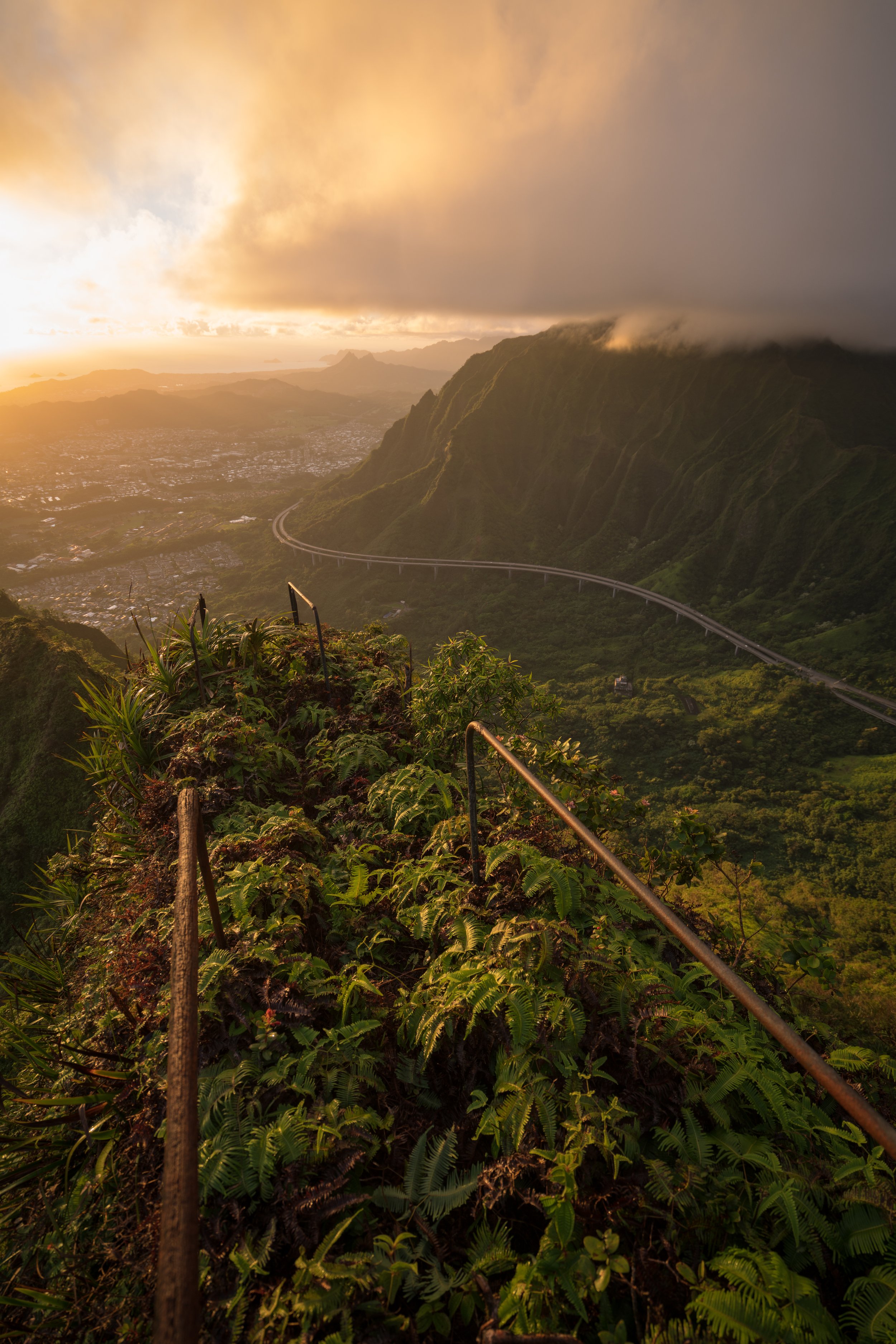
The Poamoho Trail in the northern Koʻolau Mountains on Oʻahu is, in my opinion, the best second-best day hike on the island! To be fair, the best trail is not open to the public—and no, I’m not talking about Stairway to Heaven.
I say this because the Poamoho Trail is a relatively easy, well-maintained, and remote hike through one of the most beautiful and pristine native Hawaiian forests on the island—not to mention that the views from the summit cannot be beaten on a clear day!
By this, I mean that there are few places on the island where the summit views look out toward an entirely undeveloped landscape, the other most notable is the Keaʻau Middle Ridge Trail on the West Side of Oʻahu. However, what’s perhaps even more notable is that the Poamoho Trail is, for the most part, very flat—gaining just 580 ft. (177 m) over 3.3 miles (5.3 km) from the trailhead to the summit.
This slow climb is hardly even noticeable over the length of the trail, making the Poamoho Trail much easier than it may seem for such a remote day hike!
All this to say, Poamoho is a personal favorite of mine because of the stunning views, the well-maintained trail, and the permit system in place, which helps to limit the number of hikers accessing it on any given weekend!
How to Get a Permit for the Poamoho Trail?
The Poamoho Trail is accessible to the public by permit only, as gate codes are needed to drive the long access road up to the trailhead.
That said, the Poamoho Trail is only open to hikers on select days of the week—specifically Friday–Monday, including state and federal holidays.
This is designed to limit the number of visitors on the trail each day, but obtaining a Poamoho Trail permit is not difficult and has gotten easier over the years compared to the mail-in and in-person-only options of years past.
However, there is still the option to do a same-day pickup at the downtown office in Honolulu or mail in an application to the address listed at the top—though, the easiest and most convenient option is the online application linked below.
Note that a permit holder can only receive one Poamoho Trail permit every 30 days.
Book Here: Poamoho Trail Permit
How Early is it Necessary to Submit a Poamoho Application?
With the new online application, I’ve had very good luck receiving a permit back for an upcoming weekend when my application was submitted on Wednesday or earlier, granted that the next few days were not state or federal holidays.
However, if you’re within this window of an upcoming weekend, the best thing to do is to walk into the downtown office during normal business hours (8 a.m. – 3:30 p.m.), and you should have a valid permit in hand within a few minutes.
As for mail-in applications, your letter should be received 10 days or more before your desired hiking date, which should allow enough time for it to be mailed back to you.
Driving to the Trailhead [4x4 Only]
The Poamoho Trailhead is located at the very end of the 5.9-mile (9.5 km) Plantation–Poamoho Hele Loa Access Road, which begins at a locked gate on the right-hand side of Paʻalaʻa Uka Pūpūkea Road, just before the Helemano Military Reservation.
That said, this gate and the codes provided is exactly why the permit is necessary!
As for the drive itself, Plantation–Poamoho Hele Loa Access Road certainly is not the most challenging 4WD road on Oʻahu. In comparison, the North Shore of Kaʻena Point is far more difficult.
However, I wouldn’t recommend anything less than a high-clearance, 4x4 vehicle, as there are typically quite a lot of potholes and a few big puddles if it has recently been raining.
Google Maps Directions: Poamoho Gate (Paʻalaʻa Uka Pūpūkea Road)
Plantation–Poamoho Hele Loa Access Road
In my experience, the drive should take about 25–30 minutes each way, but it can be faster if the road has recently been fixed up!
Poamoho Trailhead Parking
At the end of the 5.9-mile (9.5 km) access road, parking for the Poamoho Trail can be found in one of a few places just prior to the trailhead.
Before setting off, I ask that you please be courteous to other cars by allowing plenty of space to turn around in the largest areas.
Google Maps Directions: Poamoho Trailhead
Hiking the Poamoho Trail
The Poamoho Trailhead is located where the road abruptly comes to an end.
The main reason I like to say the Poamoho Trail is an easy trail is because there’s hardly any steep elevation change, and what elevation it does climb is generally maintained on the gradual hike up to the summit.
However, the very beginning of the Poamoho Trail is one exception to this sentiment, as the trail descends about 180 ft. (55 m) over the first 0.5 miles (0.8 km) before it starts making its way up to the summit, which becomes more noticeable at the bench ahead, as well as on the return hike.
This chicane fence is always a nice sign you’re getting close to the Poamoho Trailhead on the return hike!
One of the cool things about the Poamoho Trail is that hikers can see two of the most common endemic Hāpuʻu ferns growing directly alongside the trail—even alongside one another!
That said, telling the two most common species apart can be challenging, unless you know the little trick described below!
Cibotium glaucum vs. Cibotium chamissoi
There are subtle differences in the pinnae that can be hard to describe, but for a quick, easy way to determine which species you’re looking at, flip the fronds!
The underside of Cibotium glaucum will look pale/ light green, while Cibotium chamissoi will be a distinct green color (not pale).
The trees on the left-hand side are Banana, or Maiʻa in Hawaiian, which is one of a few canoe plants that can be found on the Poamoho Trail.
To add a little more context, canoe plants in Hawaiʻi are species that were brought by the original Polynesians when the islands were first discovered, allowing those that arrived first an easier way to establish reliable food sources and grow materials, as well as obtain other essentials for daily life and cultural practice.
This is the other most common Hāpuʻu Tree Fern growing just a few steps away from the one previously shown, and note that the underside of the frond is more pale.
This is the bench that I mentioned previously, where the Poamoho Trail begins a more noticeable, but still gradual descent.
However, it’s not until the hike back that the hill becomes significant, which, in my opinion, is the most 'challenging' elevation change of any section on the entire trail.
Sections on the ridgeline like this are quite rare, as the Poamoho Trail almost always favors one side or the other.
That said, this is the first of four times the Poamoho Trail meets the ridgeline on the hike to the Koʻolau Summit.
It’s worth noting that a bright, sunny day like this is quite rare on the Poamoho Trail!
In fact, this hike was by far the nicest weather I’ve ever experienced on the Poamoho Trail—which is to say, it certainly rains a lot in the northern Koʻolaus!
This is why I highly recommend bringing a good rain jacket, even if the forecast looks perfect, like I got lucky with here!
This again is one of the very few times the Poamoho Trail traverses the ridgeline, which is one of the main reasons the hike is not very hilly, similar to the second half of the Waimano Trail.
If you’re counting, this is the second of four times the trail meets the ridgeline, which can be nice to keep in mind, as much of the Poamoho Trail all looks the same!
I personally don’t think this section 'exposed' section is any different from the rest of the Poamoho Trail.
For those that may be familiar, the Poamoho Trail is a lot like the contour on the Puʻu Kōnāhuanui Trail, in that it traverses in and out of seemingly endless little gullies along the ridgeline, which is why so much of the hike to the summit looks the same.
This is why I try to highlight a few more of the noteworthy landmarks, like where the trail actually follows the ridgeline, because otherwise the 3.3 miles (5.3 km) up to the summit can feel very long, as if little progress is being made.
Paʻiniu is a fairly common, overlooked native plant in Hawaiʻi, but it’s great to come across because it means that pigs aren’t present—or at least not common—in this area, as they like to eat Paʻiniu.
This bridge is also another great mental checkpoint on both the hike up and down.
If you happen to get lucky booking a permit on a day with a beautiful forecast like this, I also recommend hiking in a hooded sun shirt, given that 6.6 miles (10.6 km) is inevitably a long day in the outside.
Now, this may sound counterintuitive, given that I also said it rains a lot on the Poamoho Trail, but in a typical Hawaiʻi trade-wind weather pattern, mornings are usually sunnier, while the midday-to-late-afternoon hours are when clouds tend to build.
This is why it’s important to be prepared for both. However, I really got lucky on this day with Kona winds—not to mention, I’ve hiked Poamoho many times in the pouring rain!
It’s always great to see an ʻĀlaʻa tree, considering they are a species of concern—meaning, they are not as common as they once were.
On a clear day, the Koʻolau Summit can look much higher and farther away than it actually is, especially when the trail starts to get close to the top!
I say this because even when the Poamoho Trail is within the final 0.5 miles (0.8 km), it still looks like there is quite a bit of climbing to do. However, the Poamoho Trail is really deceptive, as the summit is more a low point, like the Kamiloʻiki Ridge Trail summit, than a peak, like the Waʻahila Ridge Trail to the summit of Mt. Olympus.
This stretch through the Strawberry Guava is often one of the muddier areas on the hike up the Poamoho Trail.
The broad-leafed plant on the left-hand side of the photo below is called Ti, or Kī, and it’s another of the many Hawaiian canoe plants that can be found along the Poamoho Trail.
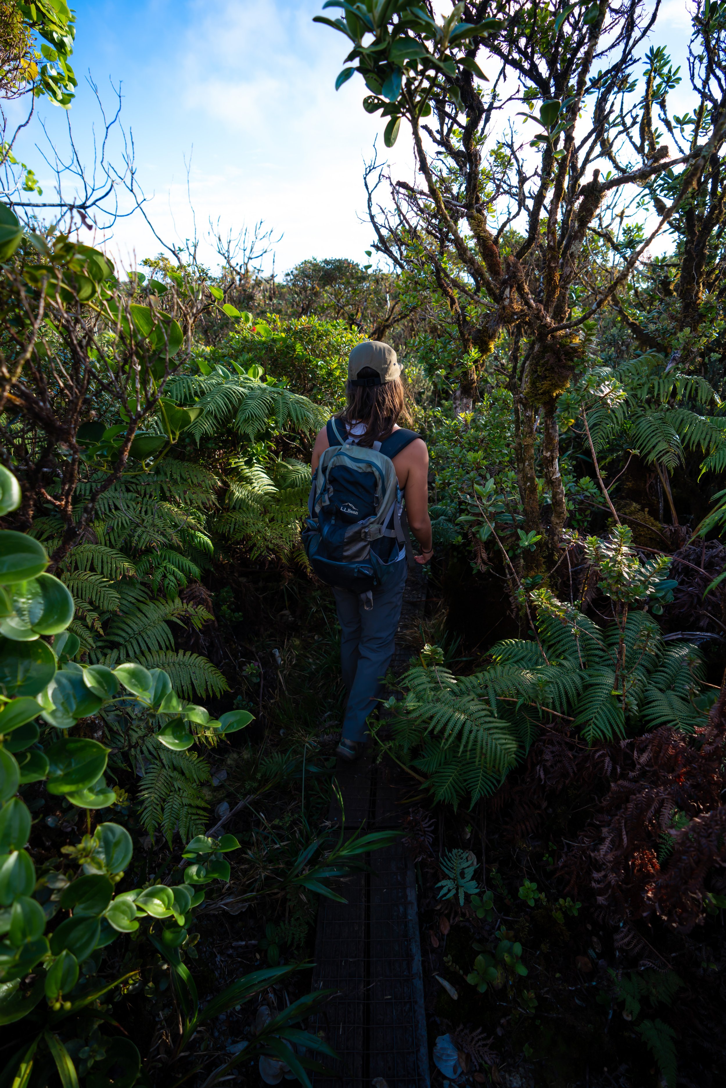
Even though I wouldn’t consider the Poamoho Trail a difficult adventure by any means, I recommend wearing good hiking pants for the overgrowth, as it is certainly not the most trafficked trail on the island, given the permit system.
All that to say, the pants below are my recommendations that hold up the best with the overgrowth here in Hawaiʻi, but with any hiking pants that need to be durable, make sure that they are at or near 100% nylon. This is really the most important factor!
Elaphoglossum ferns are very common across Hawaiʻi’s wet forests, but they are often overlooked compared to much more noticeable plants and trees, like ʻŌhiʻa lehua.
What is the ʻEwa Forest Reserve?
The ʻEwa Forest Reserve is one of the most pristine and publicly accessible native forest reserves on the Island of Oʻahu!
That said, the ʻEwa Forest Reserve, like other reserves in the northern Koʻolaus, is an incredibly invaluable place, as it is one of the last remaining largely intact Hawaiian forests on the island—not to mention that it serves as a refuge for some of Hawaiʻi’s rarest endemic plant species.
I mention the words 'publicly accessible' because, while there are certainly other similar forest reserves across the island, by and large they are not nearly as easy to access as the Poamoho Trail and the Schofield–Waikāne Trail make the ʻEwa Forest Reserve.
This is where the Poamoho Trail makes a sharp turn to the north, which can be seen on a map of the trail.
After the sharp turn to the north, the Poamoho Trail begins climbing up to the ridgeline for the third time on the hike, which is also where the trail will switch over to the other side of the ridge.
This is where the top of the ridgeline, where the Poamoho Trail switches to the other side, can be seen for the first time through the trees!
This is the third of four times the Poamoho Trail traverses the ridgeline.
With almost exactly 1.0 mile (1.6 km) to go, the Poamoho Trail switches to the north side of the ridgeline, beginning some of the most beautiful and pristine sections of the entire hike!
This is where the Poamoho Trail begins to parallel the fence around the Poamoho Management Unit, which it will eventually pass through just a short distance ahead.
This is the fourth and final time the Poamoho Trail follows the ridgeline—meaning that from this point on, the trail will contour the north side of the mountain for the rest of the hike to the Koʻolau Summit.
Hame trees are a preferred species for Hawaiʻi’s endemic Kāhuli, and if you ever see the Kāhuli at the Bishop Museum in Kalihi, Hame leaves are often the ones used within the container.
Poamoho Management Unit (North Fence)
This is where the Poamoho Trail enters the Poamoho Management Unit that encloses much of the area surrounding the uppermost elevations near the Koʻolau Summit, which is designed to keep non-native, invasive ungulates out of the native forest.
That said, please ensure that the gate latches after passing through, both on the hike up and back down.
On the uppermost elevations of the ridge, the Poamoho Trail traverses a largely intact native Hawaiian forest, which should be most evident from the lack of Strawberry Guava trees, unlike the beginning few miles of the hike.
I mention this because it really is important to do what you can to minimize your impact on the Poamoho Trail.
I think photos can make these sections look more difficult than they really are, though I still recommend wearing nylon hiking pants, which is true for countless upper-elevation Hawaiʻi adventures!
Similar to the Hāpuʻu ferns mentioned at the beginning of this article, both ʻŌlapa, or Lapalapa, tree species can be seen on the hike up Poamoho, with this one being the more common of the two.
Similar to the other side of the ridge, the Poamoho Trail winds its way in and out of countless gullies, the most significant and notable being the final one just below the Koʻolau Summit.
It’s always great to see either of Oʻahu’s endemic ʻOhe Mauka trees—this one being much more common than Polyscias gymnocarpa!
This is where the Poamoho Trail turns the corner to begin traversing the final gully before the Helemano Stream just ahead!
When the Poamoho Trail turns this corner and begins to parallel the upper origins of the South Fork of the Helemano Stream, the Koʻolau Summit is just 0.3 miles (0.5 km) away!
South Fork of the Helemano Stream
This is where the Poamoho Trail steeply drops down to cross the South Fork of the Helemano Stream.
On the far side of the stream, go left to continue hiking up to the Koʻolau Summit.
After the stream crossing, the Poamoho Trail will noticeably climb up and out of the gulch.
This is why I mentioned at the beginning that there are a few sections with some elevation change, though it truly doesn’t last very long!
This is where the Poamoho Trail turns the corner to leave the gulch behind.
This is where the Poamoho Trail passes through the same management unit fence from earlier, just a few steps below the summit.
Again, please close the gate after passing through!
Koʻolau Summit Trail (KST)
This is where the Poamoho Trail reaches the Koʻolau Summit Trail (KST).
That said, the Poamoho Trail is by far the easiest access trail to the north KST, which is why it’s one that I always recommend utilizing if completing the entire hike is on your bucket list.
However, the sections on the KST, both to the north and south of Poamoho Summit, are easily some of the hardest, most overgrown miles of the entire cross-island hike.
I say this because to the north, the next best trail down is Papali Ridge to the Maʻakua Ridge Trail in Hauʻula, which is quite a hike away—especially considering the sections immediately north of Poamoho are very slow going.
As for the sections heading south, the Poamoho Trail begins on a very light and fast section to Schofield-Waikāne, but this doesn’t last very long, as the trail abrupty becomes more challenging on the hike to Mānana Ridge beyond.
This is why I highly recommend turning around after reaching Poamoho Summit, as the KST in either direction is nothing to take lightly—and, honestly, very few hikers actually have what it takes to hike from Pūpūkea to Mānana Ridge, considering how overgrown it really is!
Read My Separate Post: Koʻolau Summit Trail (KST)
Poamoho Summit
There are few viewpoints on Oʻahu that compare to Poamoho Summit on a clear day!
That said, the views from the summit look across much of Punaluʻu and Kahana Valley, including notable east-side peaks, such as Puʻu Piei, Puʻu Manamana, Puʻu Kānehoalani, and Puʻu ʻŌhulehule from left to right in the photo below.
Native Plants on the Poamoho Trail
The Poamoho Trail is one of the best trails on the island for spotting various native Hawaiian plants, some of which include ʻŌhiʻa lehua (all three Oʻahu endemic species), ʻAhakea, Kōpiko, ʻĀlaʻa, Akaʻawa, Māmaki, Naʻu, ʻOhe Mauka, Hāpuʻu, Koliʻi, Alani, Kokolau, and multiple Naupaka species—to truly name only a few.
To add to this, Poamoho is also one of the most valuable conservation areas on Oʻahu, which is why I ask that you do everything you can to minimize your impact while hiking.
If you are curious about trying the native Hawaiian Māmaki tea, I kindly ask that you don’t harvest Māmaki from our native forests but, instead, buy from one of the local reputable vendors, such as those listed below.
If you would like to learn more about these and many other native Hawaiian plants from across the islands, I encourage you to check out my separate post linked below.
Read My Separate Post: Native Hawaiian Plant Guide