Hiking the ʻAiea Loop Trail on Oʻahu, Hawaiʻi
Distance: 4.9 miles / 7.9 km
The ʻAiea Loop Trail in central Oʻahu is a well-trafficked, well-maintained day hike within the Keaīwa Heiau State Recreation Area that is renowned among both locals and visitors for a number of reasons.
The first is that the ʻAiea Loop Trail is one of the best kid-friendly hikes on Oʻahu, which largely has to due with how well-trafficked the loop is, the minimal elevation gain, and after it has recently rained, the ʻAiea Loop Trail almost always dries out quicker than other Oʻahu day hikes.
On top of this, the ʻAiea Loop Trail is one of the best trail runs on Oʻahu, with relatively easy grades, great views, and a route that is easy to navigate.
Before visiting for the first time, know that the upper half of the loop is considered the easier half, but the lower half that parallels the H-3 freeway has many more beautiful viewpoints to enjoy. This is why I highly recommend completing the entire loop, regardless of the trailhead you choose to begin.
ʻAiea Loop Trailhead Parking
The ʻAiea Loop Trail is located within Keaʻīwa Heiau State Recreation Area.
That said, parking for the ʻAiea Loop Trail can either be at the upper or lower trailhead, depending on which direction you decide to hike.
In either case, part of the full loop, whether at the beginning or end, will involve walking the road a short distance to get back to your car.
Google Maps Directions:ʻAiea Loop Trailhead
Hiking the ʻAiea Loop Trail
Typically speaking, I like to begin the ʻAiea Loop Trail on the upper half, which is the easier of the two trailheads to find because it’s located at the very top of ʻAiea Heights Drive.
ʻAiea Loop Upper Half
The upper half of the ʻAiea Loop Trail begins on a very gradually trail, and it will gain roughly 550 ft. (168 m) in about 1.6 miles (2.6 km) to the high point on the trail.
At no point is the elevation gain ever too feel steep, making ʻAiea Loop one of the best Oʻahu trails for young kids, people of all ages, and trail runners.
ʻAiea-Kalauao Falls Loop Junction
At about the 0.4-mile (0.6 km) mark, you may notice a trail branching off the ʻAiea Loop.
This is the split for Kalauao Falls, but if you weren’t planning on hiking the Kalauao Falls Trail, don’t leave the ʻAiea Loop, as Kalauao is a much more challenging and confusing hike than the ʻAiea Loop Trail.
Read My Separate Post: Kalauao Falls Loop Trail
This bench is one of the best viewpoints on the upper half of the ʻAiea Loop Trail.
ʻAiea Ridge-Upper Kalauao Falls Loop Junction
When you reach this junction on the trail at about 1.6 miles (2.6 km), you’ve reached the uppermost part and the start of the lower half.
This is the junction for the ʻAiea Ridge Trail that leads up to the Koʻolau Summit and the infamous Stairway to Hell. Additionally, this junction is also where the Kalauao Falls Loop meets back up with the ʻAiea Loop from the earlier split.
I think it’s important to know that hiking any part of ʻAiea Ridge should be done with more careful planning/ preparation than the ʻAiea Loop Trail, and ʻAiea Ridge is not a kid-friendly hike.
There are good views if you choose walk up to the start of the ridge, but I personally think that the views get better once you proceed down the lower half of the ʻAiea Loop.
Read My Separate Posts: ʻAiea Ridge Trail (Stairway to Hell) / Kalauao Falls Loop
ʻAiea Loop Lower Half
Once past the ʻAiea Ridge junction, you have officially begun the lower half of ʻAiea Loop, which is roughly 3.3 miles (5.3 km) in total.
As you can clearly see from the differences in distance, both 'halves' of ʻAiea Loop aren’t really halves. The lower half is clearly longer, but breaking them up where ʻAiea Loop meets ʻAiea Ridge makes the most sense because at this point, most of the remaining distance is downhill, with the exception of the last 0.7 miles (1.1 km).
That said, the lower half of the ʻAiea Loop is arguably the harder half because it descends lower than the upper half to cross the ʻAiea Stream and then climbs back up a number of switchbacks to get back to the state park.
However, in reality, it’s not much more difficult than the upper half, and the lower half is where the best views on the trail are located!
This is my favorite viewpoint on the ʻAiea Loop Trail.
Stay to the right on the more defined trail.
The path heading up the ridge is a small side trail that meets back up with the ʻAiea Loop a little further down the hike.
In my opinion, the views aren’t better than the viewpoints in the photos above, but it can make for a nice alternate route if you’ve hiked the ʻAiea Loop before.
Toward the end of the lower half, you can start to see the state park across the valley.
The trail to the left leads out to an alternate trailhead at the top of Hālawa Heights Road.
ʻAiea Stream
Depending on how much rain the area has gotten, the ʻAiea Stream crossing may be significantly muddier than what’s shown in the photo below.
On the far side of ʻAiea Stream, there is only a few switchbacks to climb back out of before reaching the lower ʻAiea Loop Trailhead.
Lower ʻAiea Loop Trailhead
Once back in the Keaʻīwa Heiau State Recreation Area, turn right to take the fastest route back up to the upper ʻAiea Loop Trailhead.
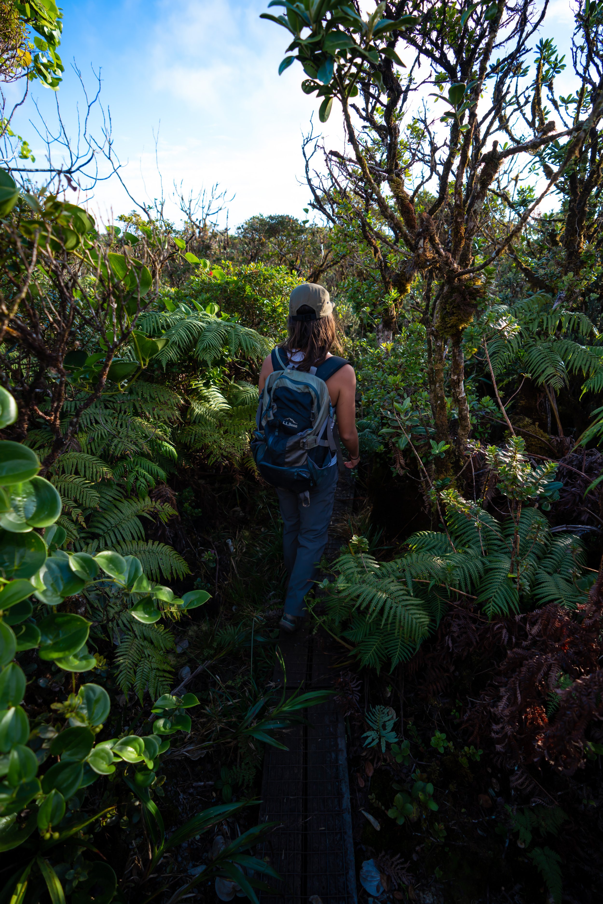
Native Plants on the ʻAiea Loop Trail
Since the ʻAiea Loop Trail is relatively a low-elevation trail, most of the plants you will hike by are non-native/ invasive species. It isn’t until the Koʻolau Mountains gain elevation up ʻAiea Ridge that native plants really start to dominate.
However, there are number of native plants that can be found by on the loop trail, including ʻŌhiʻa lehua, Alaheʻe, ʻIliahi, Neleau, Uluhe, Kupukupu, and Koa, to name a few.
If you’d like to learn more about these and tons of other native Hawaiian plants from across the islands, I encourage you to check out my separate post linked below.
Read My Separate Post: Native Hawaiian Plant Guide