Hiking the Mist Trail to Vernal & Nevada Falls in Yosemite National Park
Distance (One Way to the Top of Nevada Falls): 2.8 miles / 4.5 km
Distance (Full Mist-John Muir Loop Trail): 6.4 miles / 10.3 km
The Mist Trail to Vernal and Nevada Falls, commonly called the Mist–John Muir Loop Trail in Yosemite National Park, is a beautiful and popular day hike out of Yosemite Valley, where visitors can experience not one but two stunning waterfalls on this unique trail that gets sprayed by the mist as it ascends past Vernal Falls.
That said, the Mist Trail is the second most popular day hike in Yosemite Valley, behind only Lower Yosemite Falls, because the Happy Isles Trailhead is not only used to hike to Vernal and Nevada Falls, but it also serves as the most popular trailhead for Half Dome, the Diving Board, and even Clouds Rest—which is often combined with Half Dome.
I say this to emphasize that I highly recommend hiking the Mist Trail either early or late in the day to avoid the vast majority of the crowds, while avoiding the Mist Trail from about 9 a.m. to 3 p.m. during the busiest summer months. This is when the busyness of the Mist Trail can really make the experience much less enjoyable, as certain sections—particularly through Vernal Falls—can become a very slow-moving single-file line because of the crowds.
All that being said, both Vernal and Nevada Falls are truly a must-see when visiting Yosemite National Park—especially Nevada Falls from the John Muir side of the loop!
Happy Isles Trailhead Parking
Parking for the Mist Trail is located at the Happy Isles Trailhead in the very back of Yosemite Valley, either in the dirt lot just past Curry Village or along Happy Isles Loop Road, with many visitors parking as far away as Yosemite Village and relying on the free shuttle to get to and from the trailhead.
That said, the Happy Isles Trailhead is one of the most challenging places in Yosemite National Park to find parking—unless you arrive first thing in the morning, which is what recommend for most adventures in and around Yosemite Valley.
Google Maps Directions:Mist & John Muir Trailhead (Happy Isles)
Hiking Checklist - Yosemite
Here is a complete list of must-have things that you will want for any hike in Yosemite National Park.
That said, bear spray is purposefully excluded from this list because, while the Sierra Nevadas are home to a large Black Bear population, bear spray is not allowed in Yosemite National Park.
Hiking the Mist Trail to Vernal & Nevada Falls
The Mist Trail/ John Muir Trail begins at the Happy Isles Trailhead on the far side of the Merced River from the shuttle stop.
Those parking in the dirt lot or along the road by Curry Village can utilize the Yosemite Valley Loop Trail or the shuttle to reach the trailhead, as it is at least a 0.6-mile (1.0 km) walk each way from the closest parking area.
Initially, the hike begins on a very flat trail, but this will quickly change, as the entire 6.4-mile (10.3 km) Mist–John Muir Loop to Vernal and Nevada Falls is almost always climbing or descending one of many steep sections.
After just 0.4 miles (0.6 km), the Mist Trail makes a hard left turn to begin the ascent up to Vernal Falls.
This is also where the Mist Trail becomes paved and continues all the way to the Vernal Falls Bridge, about 0.9 miles (1.4 km) into the hike.
This sign at the beginning of the Mist Trail is strikingly similar to the sign at the beginning of the Crescent Meadow Loop Trail in Sequoia National Park, which marks the start of countless different adventures on the High Sierra Trail, such as the Mineral King Loop.
It really is fun to look at when you think about all the possibilities one can reach throughout the Sierras and beyond, like Mt. Whitney, more than 200 miles (322 km) away!
This is where the Mist Trail noticeably begins gaining elevation, a climb that remains fairly steep all the way to the top of Nevada Falls.
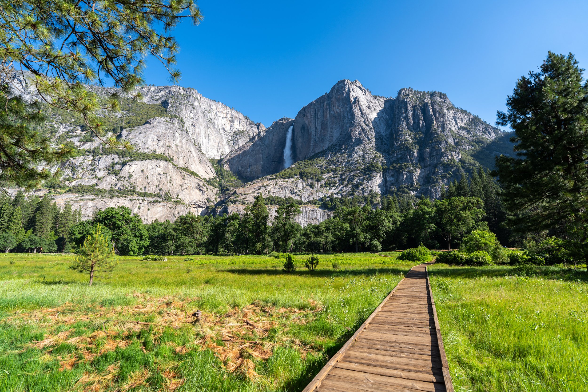
From this viewpoint, hikers can see Upper Yosemite Falls in the distance!
On a sunny day in Yosemite, which is very common in the Sierras during the summer, I highly recommend hiking in a hooded sun shirt to stay safe—something that can certainly be useful here and on countless other adventures throughout the park.
After roughly 0.9 miles (1.4 km), the Mist Trail crosses the Merced River for the first of three times before returning to this bridge at the very end.
That said, the Vernal Falls Bridge is a good sign that the beginning of the Mist Loop Trail is not far ahead.
Outside of filtering, the far end of the Vernal Falls Bridge is the last place for visitors to get water on the hike to the top of Vernal and Nevada Falls.
With that in mind, all hikers should carry at least 2–3L of water for the steep Mist Loop Trail, which is why I highly recommend traveling to Yosemite with a good water bladder, like the one listed below.
After the Vernal Falls Bridge, the Mist Trail continues for another 0.2 miles (0.3 km) until it reaches the John Muir Trail junction.
Lower Mist-John Muir Junction (Mist Loop Trail)
This is the lower junction where the Mist Trail and John Muir Trail split for the first time, effectively creating the Mist Loop Trail.
Here, hikers can either ascend the John Muir Trail to the top of Nevada Falls first by going right, but it is much more common to continue straight on the Mist Trail toward Vernal Falls, returning on the John Muir Trail at the end.
This is the direction in which this article is written.
Mist Trail vs. John Muir Trail
Whether to hike up the Mist Trail or John Muir Trail—especially when hiking Half Dome—is a fair debate, but I strongly feel that the Mist Trail is the better choice for hiking the full Mist–John Muir Loop Trail, Half Dome, and even the Diving Board.
I believe this because the Mist Trail, while steeper, is very direct and straight to the point, whereas the John Muir Trail is much longer, more out of the way, less fun, and the views aren’t as good.
That’s not to say I recommend against returning on the John Muir Trail, but when it comes to hiking up—especially when trying to get to Half Dome and the Diving Board as fast as possible—I highly recommend the Mist Trail, as it totals about 1.5 miles (2.4 km) from this point to the top of the loop, compared to 2.7 miles (4.3 km) on the John Muir Trail.
What is the Winter Route?
The winter route refers to a route that intentionally avoids both the Mist Trail from here to the top of Vernal Falls and the John Muir Trail between Clark Point and the Panorama Trail, while utilizing the connector in between.
This is because both routes can become extremely dangerous during the colder months of the year, as mist from Vernal Falls turns into ice on the steep sections by the waterfall, and water and rocks falling on the John Muir Trail between Clark Point and the Panorama Trail can make it particularly and unnecessarily dangerous.
Regarding my thoughts above, I chose to go straight on the Mist Trail toward Vernal Falls.

Mist Trail
This is where the Mist Trail begins—the steep, and soon-to-be-wet, sections up and around Vernal Falls.
This turn is where the Mist Trail will noticeably begin to get wetter and wetter until it reaches the uppermost sections closest to Vernal Falls.
Some hikers may prefer to carry trekking poles for the very steep, wet sections near Vernal Falls.
This first flat section is one of the better places to take photos on the hike up Vernal Falls, as it is conveniently protected from the worst of the mist.
Once through the rock tunnel, the Mist Trail enters the wettest part of the entire hike past Vernal Falls, which is why some visitors prefer to wear rain jackets for both the hike up and down.
After climbing to the top of the wettest section shown above, the Mist Trail becomes significantly drier around this flatter section, which is where I personally think the best places to take photos on the entire trail can be found!
Immediately past Vernal Falls, the Mist Trail continues up a very steep stretch, which essentially continues with no breaks until the top of Vernal Falls.
Yes, it’s really this steep!
Choosing the Mist Trail over the John Muir Trail will be a significantly steeper climb, but I truly think it’s worth the effort because of the beautiful sections below—and to cut out about 1.2 miles (1.9 km) to reach the uppermost part of the loop.
Just before the top of Vernal Falls, the Mist Trail traverses a very short but narrow section that can become a bit of a bottleneck as hikers squeeze past one another.
At the top of the narrow section, the Mist Trail opens up, with the path continuing to Nevada Falls on the right and the top of Vernal Falls straight ahead.
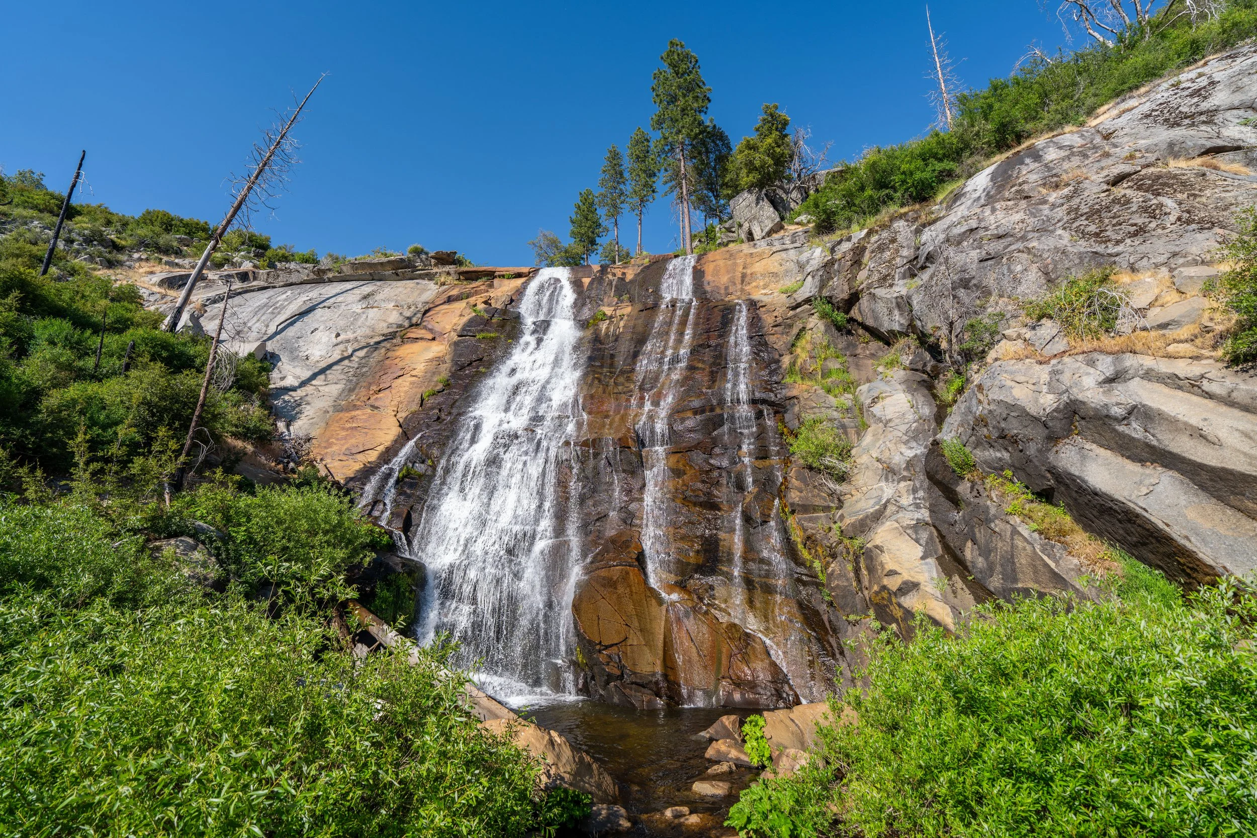
Top of Vernal Falls
The top of Vernal Falls is this panoramic viewpoint overlooking the 317-ft. (96.6 m) waterfall, which marks the most popular turnaround point on the Mist Trail after the Vernal Falls Bridge.
That said, the number of hikers continuing on the Mist Trail to Nevada Falls—about 1.3 miles (2.1 km) away—significantly drops from this point on.
To continue up the Mist Trail to Nevada Falls, simply continue upstream and the trail will eventually narrow as it climbs its way to the top.
Just past Vernal Falls, there is another restroom with a third located at the very top of the loop.
Shortly past the restroom, the Mist Trail makes a hard right turn away from the Merced River.
Mist-John Muir Connector Junction (Clark Point Junction)
The next time the Mist Trail splits is when it comes to this short connector between the Mist Trail and the John Muir Trail, which is the winter route, as it avoids both the sections of each trail that are closed during off-season months.
That said, I personally don’t recommend following this connector at any point during the hike, because the best views to come are both on the Mist Trail to the top of Nevada Falls and on the John Muir Trail once past Nevada Falls on the way down.
All that to say, go straight (left) to continue on the Mist Loop Trail to the top of Nevada Falls.
Shortly after the Clark Point junction, the Mist Trail crosses over the Merced River once again, where it begins to make its way toward the steepest sections, up the switchbacks to the top of Nevada Falls.
After the view of Nevada Falls from the bottom, the Mist Trail begins climbing through the trees, gaining roughly 700 ft. (213 m) to the uppermost part of the loop.
When the Mist Trail breaks out of the trees, the hike begins the steepest and typically hottest section of the entire climb!
Once again, I could not recommend hiking in a hooded sun shirt more!
In my opinion, the hot summer sun makes this ascent up Nevada Falls more difficult than the Mist Trail by Vernal Falls.
In total, there are 25 or 26 short, but steep, switchbacks to the top of Nevada Falls, depending on how you count.
This short straightaway is a nice break from the steep switchbacks prior to this point.
After the 'flatter' section, the few remaining switchbacks to the top of the loop and the Mist Trail begin.
Upper Mist-John Muir Junction
This uppermost junction is the very top of the Mist–John Muir Loop Trail, and it’s where the John Muir Trail continues to popular destinations such as Little Yosemite Valley, the Diving Board, and Half Dome, which you can read about in either of my separate posts linked below.
However, to continue on the Mist-John Muir Loop toward Nevada Falls, go right, and the top of the waterfall will be found about 0.25 miles (0.4 km) away.
Read My Separate Posts: Diving Board Trail / Half Dome Trail
Past the far end of the loop, the John Muir Trail begins the return loop on a much flatter, downhill stretch toward Nevada Falls and beyond.
Top of Nevada Falls
The top of the 594-ft. (181 m) Nevada Falls is this bridge across the Merced River, but unlike the top of Vernal Falls, the area surrounding the waterfall and river is not fenced.
I say this as a warning, as hikers have unfortunately died here in the past.
Following Nevada Falls, the Mist Loop Trail begins the easiest, most gradual section of the entire hike because, as previously mentioned, the John Muir portion of the loop is notably longer than the Mist Trail, making it a fairly gradual descent overall.
John Muir-Panorama Junction
After 0.25 miles (0.4 km) from the top of Nevada Falls, the John Muir Trail splits, with the beginning of the Panorama Trail, which extends from here to Glacier Point.
That said, I personally recommend against beginning the Panorama Trail from this point off the John Muir Trail, as it makes for a much shorter and much easier hike to get to Illilouette Falls and Panorama Point by beginning from Glacier Point—which you can read about in my separate post linked below.
Read My Separate Post: Panorama Trail
This gate is for the section of the John Muir Trail that is closed during the off-season months.
In my opinion, these sections along this steep cliff face are the most beautiful part of the John Muir side of the loop, as the switchbacks past Clark Point re-enter the trees for most of the descent back to the beginning.
Personally, I think the John Muir Trail is the best side of the loop to see Nevada Falls, compared to the switchbacks up the Mist Trail, adjacent to the falls.
Just like the ascent past Vernal Falls, some hikers may prefer to carry trekking poles for the hike down, as either trail descends about 1,950 ft. (594 m) from the uppermost part of the loop to the Happy Isles Trailhead.
Clark Point (John Muir-Mist Connector Junction)
The next time the John Muir Trail splits is when it reaches the upper junction for the connector between the John Muir Trail and the Mist Trail.
Here, go left to continue down the John Muir Trail to the beginning of the loop, which I highly recommend in order to avoid the slowest sections of the Mist Trail by Vernal Falls.
The John Muir Trail between Clark Point and the Mist Trail is the final portion of the winter route, as the switchbacks to come are considered the least hazardous during the winter off-season.
After Clark Point, the John Muir Trail descends 17 switchbacks to the junction where the loop returns to the Mist Trail.
This is honestly why I find the John Muir Trail to be more tedious than the Mist Trail, which is significantly steeper but more straight to the point.
This is Upper Yosemite Falls that can be seen in the distance!
Again, if this section feels long, it’s because it is!
Once the John Muir Trail returns to the forest, this side of the loop feels very long and monotonous, which is why I strongly recommend the Mist Trail for those with Half Dome permits—especially when hiking up for sunrise.
This is the 17th and final switchback on the John Muir Trail descent from Clark Point.
John Muir-Happy Isles Stock Junction
Just before the John Muir Trail returns to the beginning of the loop, the trail will pass by the Stock Trail, which began on the other side of the Merced River at Happy Isles.
From here, go straight, and the beginning of the loop will be found shortly ahead.
Lower John Muir-Mist Junction (Mist Loop Trail)
This is the end of the John Muir side of the Mist Loop Trail.
That said, go left to return to the Happy Isles Trailhead, about 1.1 miles (1.8 km) from this initial junction.