


Hiking the Mt. Whitney Trail via Whitney Portal in Lone Pine, California
Distance (Roundtrip): 22.2 miles / 35.7 km
Elevation Gain: ~6,165 ft. / 1,879 m
Rising nearly 14,800 ft. (4,511 m) from the nearby depths of the Badwater Basin, Mt. Whitney in the Sierra Nevada Mountains is the tallest summit in the contiguous lower 48 states and one of the most sought-after climbs for this reason alone!
That said, the Mt. Whitney Trail via Whitney Portal is the shortest and easiest route to the summit of Mt. Whitney, which inevitably makes it the most preferred route—hence, the competitive permit system in place today.
This is why I believe there is quite a bit to know before attempting the Mt. Whitney Trail for the first time, including the considerations behind each type of permit, the wildlife, the weather, and, perhaps most importantly, the month in which you plan to climb, as even just a few weeks’ time can drastically change what snow conditions are like on the upper mountain.
This is exactly why this article is so long and detailed, but to navigate around more easily, use the pop-up bubble in the right-hand corner of the page to skip to specific sections, though I believe there is very useful information written throughout the entire article.
How Long is the Mt. Whitney Trail?
Since many hikers break up the Mt. Whitney Trail in different ways, I’ve broken down each section to help you plan your adventure.
Mt. Whitney Trail Distances:
Whitney Portal to Lone Pine Lake Junction: 3.0 miles (4.8 km)
Lone Pine Lake Junction to Outpost Camp: 1.0 mile (1.6 km)
Outpost Camp to Mirror Lake: 0.5 miles (0.8 km)
Mirror Lake to Trail Camp: 2.0 miles (3.2 km)
Trail Camp to Trail Crest: 2.4 miles (3.9 km)
Trail Crest to John Muir Trail (JMT) Junction: 0.2 miles (0.3 km)
John Muir Trail (JMT) Junction to Mt. Whitney Summit: 2.0 miles (3.2 km)
Total Distance (One Way): 11.1 miles (17.9 km)
How to Get a Mt. Whitney Permit?
Between May 1 and November 1, the Inyo National Forest abides by a strict quota of 160 people on the Mount Whitney Trail, which breaks down to 100 day-hikers and 60 overnight backpackers, with a maximum of 15 people per group on the trail per day.
These permits are required for anyone within what the Inyo National Forest considers the Mount Whitney Zone, a designated zone that begins just after Lone Pine Lake and ends when the trail crosses into Sequoia National Park at Trail Crest.
That said, there are three ways to get a Mt. Whitney Trail permit, regardless of whether you are looking for an overnight or day-hiking permit. They are: enter the advance preseason lottery, which begins well before the May 1 quota date; book an unclaimed permit, meaning one that was not paid for by the deadline; or book a last-minute cancellation.
In all of my experiences, both camping and day hiking on the Mt. Whitney Trail, the best two options are entering the advance lottery and booking an unpaid permit.
If you were unsuccessful in the advance lottery, booking a permit right when they are released is what I recommend. To do this, you need to be logged in to Recreation.gov with the page open and ready to refresh the moment the minute changes, as you only have seconds to add an unpaid reservation to your cart.
The best method for securing an unpaid permit is usually to be on a group call with everyone interested in going, and hopefully, someone in your group will successfully add the permits to their cart.
Finally, it’s worth noting that claiming a last-second cancellation can also a great option. This is because throughout the summer, cancellations pop up all the time, usually one or two days in advance. While this doesn’t leave much time to plan, it can be a great option if you’re already visiting nearby destinations, like Yosemite or Lake Tahoe.
Book Here: Mt. Whitney Trail Permits
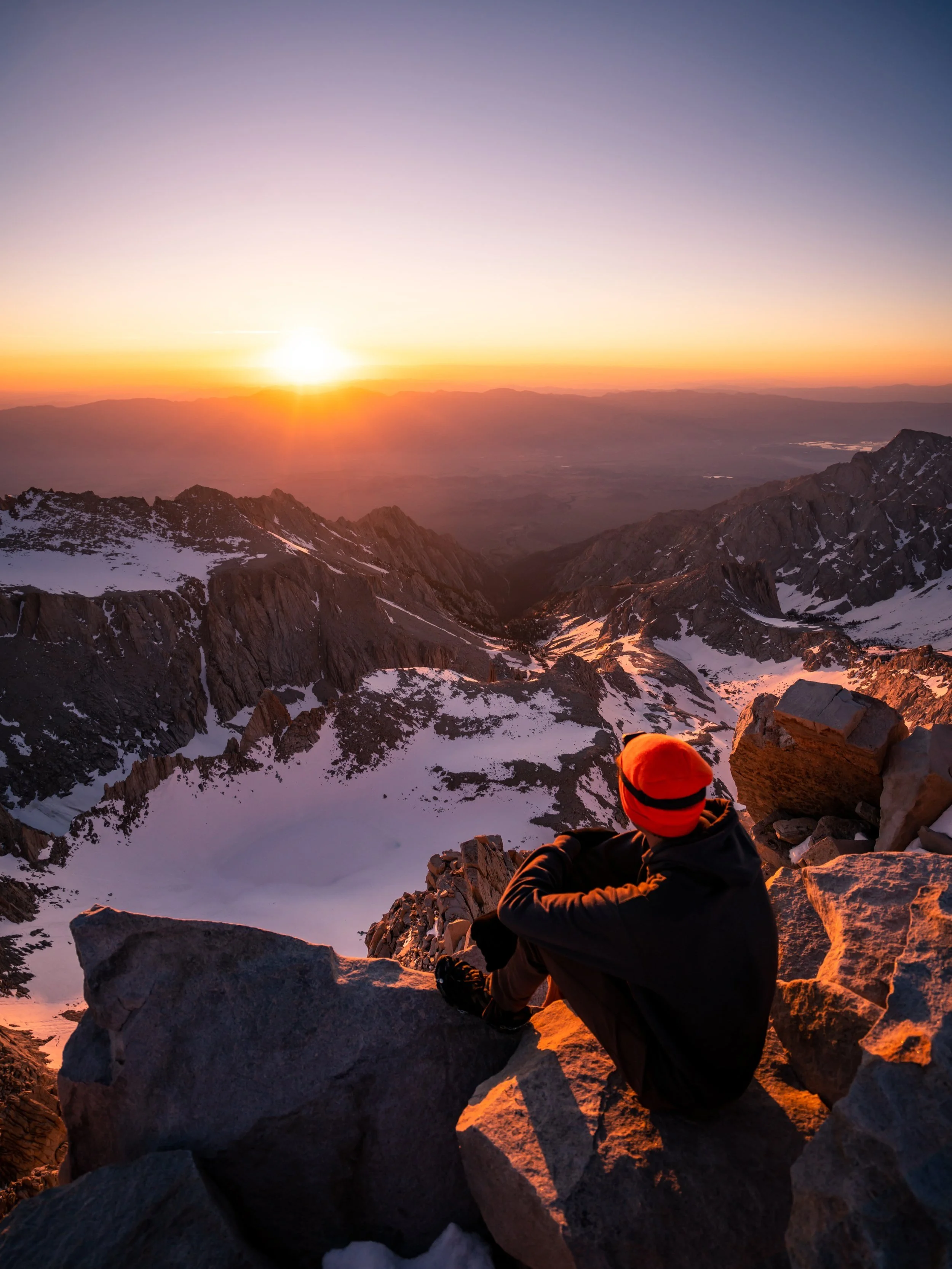
Mt. Whitney Trail (Sunrise)
What is the Best Time of Year to Climb Mt. Whitney?
Answering this question is incredibly subjective because it largely depends on your individual skill set.
By this, I mean that, following a typical snow season in the Sierras, the month of May is generally a winter climb. This means you need to be proficient with an ice axe and crampons on the upper mountain, as the switchbacks are non-existent at this time. This also means you need to know how to use and trust your tools, as the only safe way to climb is up The Chute.
However, come June, Mt. Whitney starts to change dramatically, as The Chute generally becomes unusable and unsafe at some point during the month, meaning the best way up the mountain is the switchbacks, even if they are still largely snow covered.
This is because the best time to climb The Chute in May and June is during the night, when the snow is firm. However, as the summer progresses and temperatures warm, climbing the snow up The Chute becomes very unmanageable when it’s too soft and too patchy, which starts to make it unsafe—especially for glissading.
Following June, July on the Mt. Whitney Trail is often nothing more than a hike. This is why, if you’re only interested in getting to the top, my best advice is to be patient!
Mt. Whitney can be nothing more than a beautiful backpacking trip and a rewarding climb if you book your permit after July 1, but keep in mind, there’s no telling what kind of winter the Sierras will have at the time of the advanced pre-season lottery.
Is an Overnight or Day Hiking Permit Better on Mt. Whitney?
I have done both, and again, I can tell you it’s incredibly subjective.
The benefit of camping is obviously to break up the hiking, but I’m not going to tell you that spending one or two nights on the mountain is easier.
I say this because I often believe there’s a balance between doing more miles with a lighter pack vs. fewer miles with a much bigger pack, and there’s a fair argument to be made that day hiking Mt. Whitney is easier because there is so much elevation change!
However, the physical considerations aside, I highly recommend spending one night on the mountain if it’s your first time, as spending time at Trail Camp to enjoy the alpenglow at sunset and sunrise is nothing short of amazing!
That said, I never recommend spending a night anywhere below Trail Camp because you are largely doing yourself a disservice on summit day, given that it’s only a 6.5-mile (10.5 km) hike to Trail Camp, which is more than manageable with an early start from Whitney Portal.

My Print - Mt. Whitney Trail
Mt. Whitney Trailhead Parking
Parking for the Mt. Whitney Trail is located in one of several parking lots at the very end of Whitney Portal Road, just a few miles outside of Lone Pine.
During the peak summer permit season, expect the parking area to be very full, even if you arrive during the night, as Whitney Portal is one of the most popular trailheads in the eastern Sierras.
On a different note, bear activity is very high at Whitney Portal, which is why the National Forest Service asks hikers to use the provided lockers and label their bags or containers with a name and date.
Google Maps Directions: Mt. Whitney Trailhead (Whitney Portal)
Hiking Checklist - Sierra Mountains
Obviously, for camping, you will need general backpacking gear. For this reason, I wrote a separate post about what backpacking gear is worth the money, from my experience, and what the best alternatives are to save you money.
Read My Separate Post: Best Ultralight Backpacking Gear
In addition, bear canisters are required for overnight campers, and all hikers on the Mt. Whitney Trail must carry wag bags.
Hiking the Mt. Whitney Trail
The Mt. Whitney Trailhead is located at roughly 8,340 ft. (2,542 m), or about 6,165 ft. (1,879 m) below the summit of Mt. Whitney.
If this says nothing else, know that the Mt. Whitney Trail is a near-constant ascent—particularly on the sections leading up to Trail Camp and the 99 switchbacks to Trail Crest beyond.
However, Trail Camp is only 6.5 miles (10.5 km) from Whitney Portal, which is why I always recommend spending the night there over one of the lower campsites if you have an overnight permit.
Mt. Whitney Trail Commemorative Gateway
As the Mt. Whitney Trail passes through the commemorative gateway that was constructed in 2004 to celebrate the 100th anniversary of the trail, hikers often like to weigh their packs on the scale before setting off!
On a different note, the National Forest Service provides free wag bags to hikers at the trailhead and in the Eastern Sierra Visitor Center, but I personally recommend spending a little money to travel with your own. It’s never a luxury experience if you have to use one, but in that instance, it’s certainly nicer to avoid the cheap ones provided by the USFS.
Immediately after leaving Whitney Portal, the Mt. Whitney Trail starts climbing, which will remain the case for nearly the entire hike to Trail Crest.
However, the Mt. Whitney Trail is actually fairly gradual, thanks to the many switchbacks that wind their way up the very steep elevation gradients, which is evident from all the beautiful and dramatic waterfalls that parallel the trail in Lone Pine Creek.
This is where the Mt. Whitney Trail turns the sharp switchback above Whitney Portal, one of the last places the parking area can be seen on the hike to Lone Pine Lake.
This is an unnamed creek just before North Lone Pine Creek and the junction with the Mountaineers Route.
Mt. Whitney-Mountaineers Route Junction
After roughly 0.9 miles (1.4 km), the Mt. Whitney Trail passes the junction with the North Lone Pine Creek Trail, better known as the Mountaineers Route.
That said, go straight to cross over the North Fork of Lone Pine Creek, and the Mt. Whitney Trail will enter the John Muir Wilderness just a few steps ahead.
John Muir Wilderness Boundary
This is where the Mt. Whitney Trail enters the John Muir Wilderness, which is important to mention because drones are not allowed to be flown in any federally designated wilderness area.
On this day, I passed a hiker on the switchbacks before Lone Pine Lake who shared that, while he was getting ready to hike the Mt. Whitney Trail at about 3 a.m., a bear came up and stole his pack off his car!
He later found it a few hours after sunrise with a big hole in it and all his food missing.
If all this says nothing else, hopefully this story shows why the National Forest Service requires all overnight campers to store food in a bear canister—especially considering that Trail Camp is located high above tree line.
This is where the Mt. Whitney Trail crosses above 9,000 ft. (2,743 m).
Beginning with the sharp switchback above Whitney Portal, the Mt. Whitney Trail ascends 25 switchbacks on the hike to Lone Pine Lake, gaining roughly 1,700 ft. (518 m) before reaching the junction at approximately the 3.0-mile (4.8 km) mark.
Since there is so much climbing and descending throughout the entire hike, some hikers may want to bring trekking poles on the Mt. Whitney Trail—especially when there is not enough snow on the upper mountain to warrant an ice axe but still enough that poles can make traversing various snow-covered sections safer and easier.
On Mt. Whitney, most day hikers and campers heading for the summit like to start at some point during the night, mostly for reasons related to snow conditions and weather.
However, when neither is a concern, as was the case on the day I took these photos, I started shortly after sunrise and enjoyed a very quiet hike up to Trail Camp, passing fewer than five groups in the first 6.5 miles (10.5 km).
I have to say, I’ve always appreciated the Mt. Whitney permit system on days like this, knowing that without it, Whitney Portal would certainly be much busier than it is today.
This is where the Mt. Whitney Trail turns the 25th and final switchback before the long Lone Pine Creek crossing and the junction with Lone Pine Lake.
This is where the Mt. Whitney Trail crosses above 10,000 ft. (3,048 m).
This is where the Mt. Whitney Trail crosses Lone Pine Creek, just before reaching the Lone Pine Lake junction.
Mt. Whitney-Lone Pine Lake Junction
At almost exactly 3.0 miles (4.8 km) from Whitney Portal, the Mt. Whitney Trail passes the junction for Lone Pine Lake, located just 0.1 miles (0.2 km) off the main trail.
That said, Lone Pine Lake is the most popular day-hiking destination on the Mt. Whitney Trail because it is located just outside the Mt. Whitney Permit Zone, though overnight permits for the Inyo National Forest are still required for anyone looking to camp at the lake.
In any case, go straight (right) to continue hiking up the Mt. Whitney Trail toward the permit zone, just a few steps ahead.
Whitney Zone (Permits Required)
About 0.1 miles (0.2 km) since passing the Lone Pine Lake junction, the Mt. Whitney Trail enters the Whitney Permit Zone.
This is where all hikers—regardless of whether you’re a day hiker or an overnight hiker—must have a permit.
The Whitney Zone continues from this point up until Trail Crest, where the Mt. Whitney Trail enters Sequoia National Park, and be aware that I have had my permit checked before. In fact, it was checked by a ranger about 0.5 miles (0.8 km) up the trail from this sign when I was returning on the day I took these photos.
Immediately after entering the Whitney Permit Zone, the Mt. Whitney Trail begins a second series of 15 switchbacks—13 uphill and two downhill—to reach Bighorn Park and Outpost Camp at the upper end.
This wildflower, known as Purple Mountain Health, is endemic only to California and small parts of Nevada, which is why I think finding it is always cool when hiking in the Sierras!
When I was returning from the summit of Mt. Whitney on the day I took these photos, this is roughly where the National Forest Ranger stopped me to check my permit.
It was actually a really great experience, and I even got a selfie with the ranger because it was the first time I had ever had a Recreation.gov permit checked, considering all the permitted hikes I have done over the years, including the Haleakalā Cabins on Maui, the Subway Trail in Zion National Park, and The Cables on Half Dome in Yosemite National Park, to name a few.
These downhill switchbacks, which lead to Bighorn Park—the large meadow before Outpost Camp—are often not noticed on the hike in but are certainly quite annoying on the hike back to Whitney Portal!
Bighorn Park
This is the start of Bighorn Park, the long, 0.2-mile (0.3 km) meadow that parallels the Mt. Whitney Trail before Outpost Camp.
Just above Outpost Camp, there is a beautiful, towering waterfall cascading down Lone Pine Creek that is fairly easy to reach by hiking off trail!
Outpost Camp
This is Outpost Camp, and it’s the second legal place hikers can spend the night on the Mt. Whitney Trail, though it’s commonly seen as the first choice since Lone Pine Lake is so close to Whitney Portal.
That said, I strongly recommend against camping at Outpost Camp, except in the case of an emergency, because I believe it is too close to Whitney Portal to call it a day and too far from the 99 switchbacks to make it a practical start for an early morning summit push—especially if climbing up The Chute before the snow softens after sunrise is something you need to consider.
This is obviously just one person’s opinion, but a very common itinerary is hiking up to Trail Camp on day one, summiting the very next morning, returning to Trail Camp for a second night, and returning to Whitney Portal on the third day. This is also commonly shortened by hiking back to the trailhead after reaching the summit early on day two.
After crossing Lone Pine Creek, walk straight across the large clearing to find where the Mt. Whitney Trail continues on the north side of Outpost Camp.
After Outpost Camp, the Mt. Whitney Trail ascends 17 switchbacks, gaining roughly 275 ft. (84 m) on the hike up to Mirror Lake.
Like many of the switchbacks on the Mt. Whitney Trail, those between Outpost Camp and Mirror Lake go by very quickly, which is why I personally believe the number of switchbacks makes them sound more difficult and intimidating than they really are.
Mirror Lake
This is where the Mt. Whitney Trail passes the junction for the short side trail down to Mirror Lake.
In my opinion, Mirror Lake is most beautiful in the late afternoon/ early evening hours, just before the sun sets below the ridge on the far side of the lake.
However, camping is not allowed at Mirror Lake, meaning that after Outpost Camp, the next legal place to set up for the night is Trail Camp, just below the 99 switchbacks.
As the Mt. Whitney Trail climbs above Mirror Lake, it begins to approach tree line.
I mention this because good sun protection at these high elevations is incredibly important, which is why I highly recommend wearing a hooded sun shirt to stay safe—especially early in the season, when there is a lot of snow on the trail.
This is the view looking north toward Mirror Lake.
This is where the Mt. Whitney Trail crosses above 11,000 ft. (3,353 m), which also closely coincides with tree line in this part of the Sierras.
Then, in what feels like the snap of a finger, the Mt. Whitney Trail climbs above the tree line, which is why I again want to stress the importance of good sun protection, especially for a multi-day trip on the mountain.
The sections above tree line are where Marmots start to become more and more prevalent on the Mt. Whitney Trail, and I mention this because, if you ever decide to take your pack off for a bathroom break or to filter water, it’s important to keep it nearby so they don’t chew through your gear when you’re not looking.
They really can be that quick!
Trailside Meadow
Trailside Meadow is more or less a mental checkpoint between Mirror Lake and Trail Camp, as it’s a little more than halfway between the two.
That said, camping is not allowed at Trailside Meadow, but it can be a great place to filter water on the hike—a piece of gear that I recommend carrying, even if you’re only on the trail for the day.
It’s worth mentioning that Mt. Whitney cannot be seen from this point on the trail, as the peak is located much farther to the right and only truly comes into view for the first time after Consultation Lake.
This is the final time the Mt. Whitney Trail crosses Lone Pine Creek.
Consultation Lake
With about 0.3 miles (0.5 km) to go before the start of Trail Camp, the Mt. Whitney Trail passes Consultation Lake.
For those spending one or more nights at Trail Camp, Consultation Lake is one of the best and easiest destinations to hike to while hanging out and acclimating, but remember to always prepare your tent and gear for Marmots before hiking away.
I talk more about this below.
This section, just before Trail Camp, is often a small tarn during peak summer snowmelt, but it is easy to hike around on either side.
Shortly before Trail Camp, there are a few sections that notoriously hang onto snow for much longer than most other parts of the trail.
However, when most of the trail has melted out, they almost never last more than a few steps, and the Mt. Whitney Trail is usually fairly easy to find again once on the other side.
Don’t forget to bring good sunglasses for areas like this—and, truly, for the entire upper mountain.
This is where the Mt. Whitney Trail crosses above 12,000 ft. (3,658 m), which is a nice sign that Trail Camp is just a few steps ahead!
Trail Camp
After a long, almost entirely uphill, 6.5-mile (10.5 km) hike, the Mt. Whitney Trail finally reaches Trail Camp, the uppermost campsite on the climb to the summit.
Trail Camp stretches for just 0.1 miles (0.2 km) on either side of the trail, and it’s located right at the base of the 99 switchbacks—the steep ascent up to Trail Crest.
This is exactly why I never recommend camping below Trail Camp when planning an early-morning push to the summit because, as mentioned previously, camping lower is only a disservice to yourself, given the long, steep ascent from this point to the top.
How Bad are the Marmots on Mt. Whitney?
The Marmots on the Mt. Whitney Trail are fairly aggressive, which is why it’s generally advised to leave your tent doors open anytime you leave your tent, even if just for a few minutes.
This is because Marmots are not only attracted to food but anything with a scent, like sweat, meaning they will chew a hole into your tent in seconds if you don’t make it easy for them to walk right through.
If not, your expensive backpacking tent and other gear may be ruined, which is why I believe bear canisters at Trail Camp are more for the Marmots than the bears.
Personally, I like to stash my sleeping pad in the upper pockets of my tent, off the ground, but this should apply to anything that might smell. If you can’t find a place off the ground for it, consider carrying it, but I guess it just depends on how expensive your gear is and how much you care about risking it.
This is the Trail Camp Tarn on the north side of the Mt. Whitney Trail.
This is where the Mt. Whitney Trail leaves Trail Camp and approaches the base of the 99 switchbacks.
99 Switchbacks
This is the base of the 99 switchbacks, which ascend roughly 1,540 ft. (469 m) to Trail Crest and the Sequoia National Park boundary.
That said, this is the point where hikers must decide whether to climb The Chute or the switchbacks, which should depend entirely on how much snow the Sierras received over the winter and how much has melted by the time of your permit.
99 Switchbacks vs. The Chute
I believe that most who have climbed Mt. Whitney would agree that the most ideal scenario would be to have the switchbacks clear for the hike up to Trail Crest, with enough snow on The Chute to glissade back down.
However, that is a very fine line to achieve because when the switchbacks are clear, The Chute often does not have enough snow to make it safe to ascend or descend.
That aside, during the early summer season, The Chute is the only safe way up the mountain. This is why I previously said that those climbing Mt. Whitney in May, and typically much of June, must be proficient with all things related to using an ice axe, crampons, self-arrest, etc., and climbing The Chute in the dark is not the time to learn—come prepared!
In any case, climbing The Chute is nothing more than a very steep, nonstop ascent to Trail Crest that should always be planned before the sun comes up. I can tell you from experience descending after sunrise on the summit that most climbers making their way up The Chute are quite miserable when the snow softens within an hour of the sun warming the snow.
This means that if you are climbing on a day permit, give yourself more time to reach Trail Camp than you think you need, as climbing The Chute and getting off it before the sun comes up may take 1–3 hours, depending on your fitness.
As for the switchbacks, there is not much to know, except that early in the season, when The Chute becomes unusable, portions of the switchbacks are often still snow-covered, which means that scrambling up short portions of the talus slopes is necessary to reach Trail Crest.
This is where the Mt. Whitney Trail turns the first of the 99 switchbacks up to Trail Crest.
If this slope leading up to Trail Crest were snow-covered, the best and safest way to the top would be to cut right shortly above Trail Camp toward the base of The Chute.
This snow-covered switchback is a perfect example of the short scrambling that is often required before the trail fully opens.
That said, these photos reflect what the mountain looks like and the amount of snow about 2 weeks after The Chute is deemed no longer safe to use because the snow is too soft, too patchy, and too shallow for safe glissading.
This section between Trail Camp and Trail Crest may seem very long, but in this post, I decided to include photos of all 99 switchbacks leading up the steepest section of the Mt. Whitney Trail, which may make these 2.4 miles (3.9 km) seem longer than they really are.
Mt. Whitney is the flatter-looking peak on the right-hand side of the ridgeline—not the most prominent one in the center of the photo below.
This is where the Mt. Whitney Trail crosses above 12,500 ft. (3,810 m).
Regarding my thoughts that this is a very long and very tediously written section, I personally believe that the saying '99 switchbacks' is more intimidating than this section actually is difficult.
I say this because a countless number of the switchbacks turn back and forth very rapidly, which is why I think it’s better to focus on the elevations reached—like 12,500 ft. (3,810 m) and 13,000 ft. (3,962 m)—as opposed to a seemingly arbitrary number of switchbacks.
Once again, do not take sun protection for granted on the Mt. Whitney Trail—especially considering that the vast majority of the hike below Trail Crest is in the sun from the moment it rises until very late in the afternoon.
I think the snow and the cables make this section look more challenging than it actually is.
However, if there is more snow on the trail, micro-spikes, at the very least, might be necessary to traverse sections like this safely.
The shade from this steep cliff face is what helps the snow stick around here much longer than in other areas on the upper mountain.
These beautiful purple flowers are known as Skypilot, and they are endemic to the Sierra Nevadas, meaning the species is found nowhere else on Earth!
This is where the Mt. Whitney Trail begins the very short and tight switchbacks in the middle of the slope between Trail Camp and Trail Crest, and it’s why I previously said the number '99' feels a bit arbitrary in terms of describing difficulty.
In this photo, it’s evident how short and close together many of the switchbacks are—much like the Walter’s Wiggles on the Angels Landing Trail in Zion National Park.
What is the Weather Like on Mt. Whitney?
Some of the most useful advice I can probably give about climbing Mt. Whitney concerns the weather.
By this, I mean that the Sierra Nevadas are blessed, unlike countless other mountain ranges across the West, with typically much clearer and sunnier weather than ranges across Colorado, Wyoming, Montana, Idaho, and elsewhere.
This is one reason why reaching the summit of Mt. Whitney is, in many ways, safer than climbing much lower peaks in these other states.
However, that’s not to say there aren’t storms in the Sierras. There certainly are, and if you happen to be climbing above Trail Camp and hear thunder, see lightning in the distance, or notice dark clouds building, it is imperative that you turn around immediately!
I’ve had more than a few close calls with lightning across the West, and I can tell you from experience that it is the most vulnerable and helpless you’ll ever feel in the mountains. If you don’t believe me, you’ve probably never had a similar scary experience, but please heed this warning: Your summit is not worth it if the weather isn’t cooperating!
All that is to say, be sure to check Mountain Forecast before starting the hike, and if an afternoon storm is predicted, it is important to know when you must be back at Trail Camp or lower by setting a firm turnaround time based on your fitness and the future forecast.
Mountain Forecast: Mt. Whitney
This is where the Mt. Whitney Trail crosses above 13,000 ft. (3,962 m).
This is another area where it was necessary to cut the switchback and climb straight up the talus slope, but when the switchbacks are mostly snow-free, as was the case here, there aren’t many of these sections to navigate.
A few weeks after The Chute becomes effectively unsafe to climb, this long snow patch on the upper switchbacks often gives hikers the most difficulty.
That said, micro-spikes may or may not be helpful, depending on the time of day and how firm or soft the snow is, but if it’s soft, the best way to maintain your footing is to kick in your steps.
Kick through the soft snow to find firmer footing with the sides or heels of your shoes, and consider using trekking poles for balance.
This is where the Mt. Whitney Trail turns the 99th and final switchback before Trail Crest.
This is where the Smithsonian Institution Shelter atop Mt. Whitney becomes visible for the first time from the trail, which won’t be seen again until the Mt. Whitney Trail reaches the base of the peak as it nears the 14,000-ft. (4,267 m) mark.
This is the view looking down The Chute just before Trail Crest.
Trail Crest (Sequoia National Park Boundary)
This is Trail Crest, the end of the 99 switchbacks, and the boundary between the Inyo National Forest and Sequoia National Park.
From here, the Mt. Whitney Trail begins a somewhat tedious traverse along the west side of the ridgeline, where the trail loses elevation at times.
In fact, at no point on this traverse does the Mt. Whitney Trail climb above 14,000 ft. (4,267 m), as it doesn’t truly start ascending to the peak until the end of the traverse, at the base of the peak.
Read My Separate Post: Sequoia National Park
Immediately after leaving Trail Crest, the Mt. Whitney Trail begins a short descent, one of the most annoying parts of the hike after having climbed all the switchbacks to reach this point.
Mt. Whitney-John Muir (JMT) Junction
After just 0.2 miles (0.3 km) from Trail Crest, the Mt. Whitney Trail passes the John Muir Trail (JMT) junction, which connects with the Pacific Crest Trail (PCT) in the valley below.
Once here, go right to stay on the Mt. Whitney Trail and continue hiking toward the summit.
After the John Muir Trail junction, the Mt. Whitney Trail climbs two switchbacks before reaching the most prominent spires and peaks visible along the ridgeline from Trail Camp below.
This is where the Mt. Whitney Trail turns the second and final switchback on the roughly 2.2-mile (3.5 km) traverse from Trail Crest to the summit.
In the very early summer season—particularly during the month of May—these exposed sections on the west side of the ridge require more traditional mountaineering gear to navigate safely.
In fact, I’ve heard other climbers express that Mt. Whitney was a more technical mountain than they anticipated, which is why it’s important to prepare based on the current conditions, noting that the Mt. Whitney Trail can be anything from a hike to a full-on mountaineering experience.
Personally, I recommend reading reviews on forums like Mountain Forecast, as well as those on AllTrails, which will hopefully help you get an idea of what the trail currently looks like.
The other important thing to note about the west side of the ridgeline is that this section is always in the shade when most climbers are making their way up or down early in the morning.
As a result, the final few miles just below 14,000 ft. (4,267 m) are often very cold—especially if there’s a breeze coming from the west!
This is where the summit of Mt. Whitney can be seen for the first time since the 99 switchbacks before Trail Crest.
This is where the Mt. Whitney Trail leaves the S'brutal Tower behind to begin the less windy sections and gradual ascent just below Aiguille Junior.
In my opinion, this is a nice mental checkpoint because there is no more up and down, like the sections that immediately follow Trail Crest, meaning everything gained from this point to the end only climbs closer and closer to the summit!
This is where the Mt. Whitney Trail crosses above 14,000 ft. (4,267 m).
This is the view looking back toward Trail Crest.
This is where the Mt. Whitney Trail turns the corner on the south side of the peak to begin winding its way up the gradual western slope to the summit.
If there is any wind coming from the west early in the morning, this final slope can be one of the coldest parts of the climb!
The shelter atop Mt. Whitney is always the best sight after the long ascent from Trail Camp—or even from Whitney Portal, as it was for me on this day!
Mt. Whitney
This is the summit of Mt. Whitney, which, according to both the USGS and the National Park Service, stands at approximately 14,505 ft. (4,421 m), making it the highest peak in the contiguous United States!
If you’ve made it this far, congratulations! Hopefully, you’ll experience conditions as beautiful and calm as those I’ve been fortunate to enjoy on multiple climbs up Mt. Whitney!
The rock in the middle of the photo below is the true high point on the summit of Mt. Whitney!


