Hiking the Castle Trail on Oʻahu, Hawaiʻi
Distance: 9.3 miles / 15.0 km
Dating back to its origins in 1906, the Castle Trail on Oʻahu is one of the island’s oldest and most historic trails.
The trail, named after James B. Castle, was once used by plantation workers, engineers, and laborers to access water from the Kaluanui and Kaipapaʻu Streams to irrigate sugarcane fields. Then, as the years passed, the Castle Trail served a number of different purposes, including hiking, pig hunting, and military training, making it a vital part of the history of Punaluʻu Valley.
That said, the Castle Trail today is all but forgotten, turning a once-popular trail into one of the more challenging hikes on Oʻahu. For this reason, the Castle Trail should not be taken lightly, even if you have a lot of hiking experience in Hawaiʻi. I say this because completing the true Castle Trail from Maʻakua to Punaluʻu becomes incredibly challenging to navigate once on the Punaluʻu Valley side of the trail.
In addition, the distance posted above will only increase if you explore further up or down the Kaluanui Stream, which is one of the highlights of this long, all-day adventure!
To skip past Maʻakua and Papali Ridge to the start of the Castle Trail, click here.
Papali Ridge Trailhead Parking
Parking for the Papali Ridge Trail is located on Honomū Street in Hauʻula, the same street parking as Maʻakua Ridge and the Hauʻula Loop Trail.
That said, be sure to plan a ride, stage a car in Punaluʻu, or bring money for the bus because the Castle Trail should only be treated as a one-way hike.
Google Maps Directions: Papali Ridge Trailhead
Hiking the Castle Trail
The Castle Trail begins at the end of Hauʻula Homestead/ Maʻakua Road, which is marked by a Nā Ala Hele trail sign for both the Hauʻula Loop and Maʻakua Ridge Trail.
On a different note, don’t forget to pack a headlamp because finishing after sunset is just as likely as not, based on how slow the hike overall can be.
Shortly after passing the sign in the photo above, the road will lead through two sets of gates before reaching the true trailhead, located about 0.1 miles (0.2 km) away on the left-hand side of the road.
Maʻakua Ridge-Hauʻula Loop Trailhead
At the joint Maʻakua Ridge-Hauʻula Loop Trailhead, go left to begin the Maʻakua Ridge Trail.
Read My Separate Post: Hauʻula Loop Trail
After the left turn, stay on the Maʻakua Ridge Trail for about 1.5 miles (2.4 km) until the Papali Ridge junction on the north side of the loop.
Maʻakua Stream
Shortly after leaving Maʻakua Road, the trail will come to a large stream crossing.
The Maʻakua Stream will almost always be dry unless it has been raining heavily further up in the mountains.
Look across the stream to the right to find the trail that continues on.
After the Maʻakua Stream crossing, the trail will climb about 200 ft. (61 m) up handful of switchbacks to the start of the Maʻakua Loop.
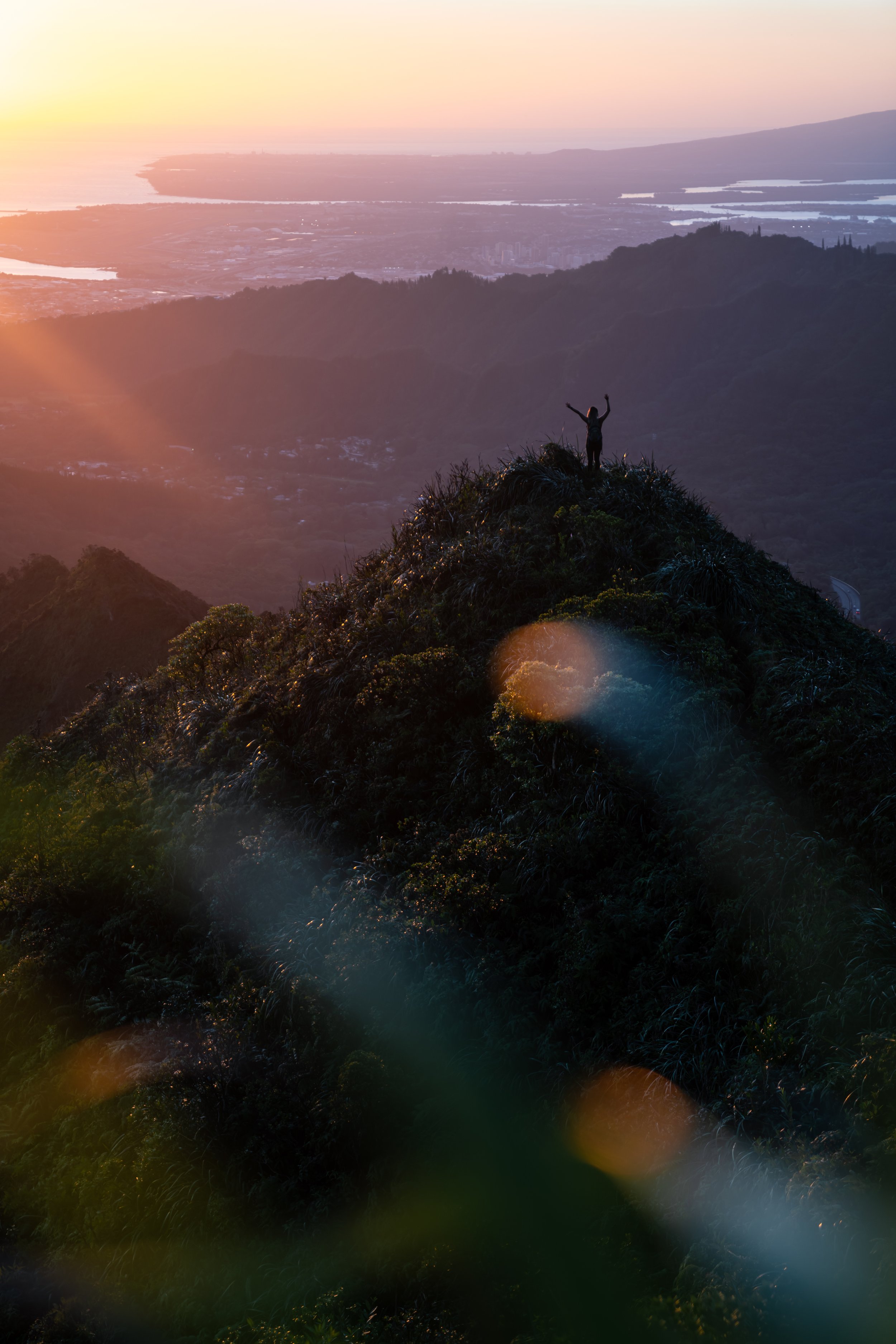
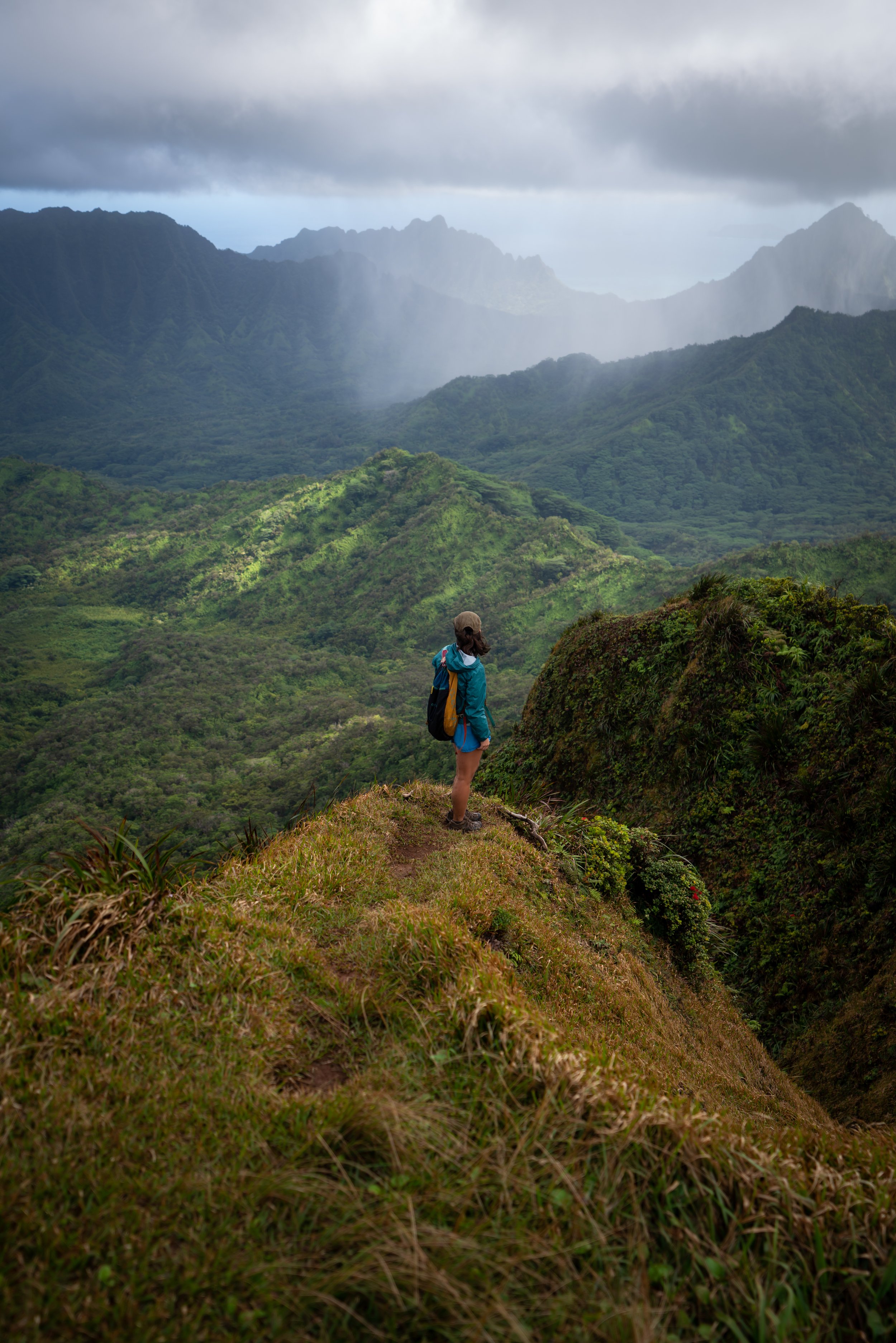
Maʻakua Ridge Bench
It’s no secret that this bench is the best—and only—viewpoint on the Maʻakua Ridge Trail.
I say it like this because the rest of Maʻakua Ridge is more or less a walk in the woods, meaning that most hikers choose to turn around after reaching this point.
Maʻakua Loop Trail
Behind the bench is the start of the Maʻakua Loop.
Here, go right to continue on the fastest route toward Papali Ridge, but if you are interested in reading about the full Maʻakua Ridge Trail, check out my separate post using the link below.
Read My Separate Post: Maʻakua Ridge Trail
Maʻakua-Papali Ridge Junction
At almost exactly 1.5 miles (2.4 km), the Maʻakua Ridge Trail splits with the beginning of the Papali Ridge Trail.
Here, go right to begin Papali Ridge and continue toward the junction for the Castle Trail.
Read My Separate Post: Maʻakua Ridge Trail
This section, from the Maʻakua junction to the Castle junction, follows the same trail up Papali Ridge, as my separate article.
This is why this section will mirror my separate Papali article, should you decide to read both. However, there is the option to skip ahead using the link below.
To skip ahead to the start of the Castle Trail, click here.
At first, Papali Ridge begins climbing through a Strawberry Guava–False Koa forest, before it ascends above these sections shortly ahead.
On a different note, Papali Ridge is one of the most unique hikes on Oʻahu in that, apart from these easier sections within the first 0.5 miles (0.8 km), Papali Ridge actually gets easier the further you hike!
Yes, once Papali Ridge reaches some of the most difficult sections within the first mile, the trail actually gets easier the closer you get to the Koʻolau Summit, which is truly an anomaly compared to all other Oʻahu ridge hikes!
It doesn’t take long to climb above the non-native Acacia trees, where Papali Ridge continues ascending into increasingly wetter terrain the higher the trail goes.
At first, these rolling hills are truly mild compared to what’s to come!
Not to be confused with the non-native passion fruit vines that can be seen growing along the trail, Lama trees are a fairly frequent sight on the lower elevations of Papali Ridge.
This steep hill is truly the start of a long climb through some of the most challenging sections on Papali Ridge, which, in my opinion, ends shortly after the 'Whale’s Belly' at Spoon Hill.
It always hurts to lose elevation on Papali Ridge, but there are a number of spots where the trail descends steeply on the way up.
Needless to say, the Papali Ridge Trail is a pants hike, and this will make more sense as the trail goes on.
That said, the pants below are my recommendations that hold up the best with the overgrowth here in Hawaiʻi, but with any hiking pants that need to be durable, make sure that they are at or near 100% nylon. This is really the most important factor!
The 'Whales Belly'
When Papali Ridge reaches this steep downhill section, you’re entering the 'Whale's Belly.'
In short, a 'Whale’s Belly' is a steep, hot, humid, muddy section, and unless it's fairly windy, the air tends to be pretty still until you get higher up on the ridge.
This is exactly the case here, and it truly doesn't change for the next 0.6 miles (1.0 km) until the Papali Ridge Trail reaches the top of the unnamed peak in the photo below.
It’s a pretty steep drop, but certainly not the steepest section on Papali Ridge.
One common theme for the first 1.8 miles (2.9 km) to Kaluanui is that the ridges on Papali come together.
This means that you can always have a good idea about where you’re going and how much further, based on the ridge to the left of Papali Ridge, as they always converge, the first being the unnamed peak previously mentioned.
This is a better view of the peak mentioned earlier, where there is roughly 650 ft. (198 m) to climb in just 0.6 overgrown miles (1.0 km) to get out of the 'Whale’s Belly.'
This is the view looking back, and I must say, the photo at the very end sums up how much effort this all takes to climb Papali Ridge—especially these initial sections!
This is a landslide in the photos below, which were both taken some years apart.
The first shows what it looks like in the years following, and the second is closer to when it actually occurred.
However, I would argue it’s worse since it has grown back because now the stable ground is tougher to see!
I love it when Kōpiko and ʻAhakea grow side by side because it’s a really great opportunity to see these two very similar-looking species in order to learn to tell them apart.
These steep sections definitely hurt more when you’re carrying gear for multiple nights on the KST.
These are the very last sections through the 'Whale’s Belly!'
When Papali tops out on the ridge, the 'Whale’s Belly,' and the hardest sections of Papali Ridge are behind you!
That’s not to say Papali Ridge gets immediately easier, but it’s surely easier and moves faster than the sections prior.
The turn in the ridge straight ahead is Spoon Hill, and it’s the best spot to take a break thus far.
Spoon Hill
Spoon Hill, located roughly 2.7 miles (4.3 km) into the hike, is truly the first and only break spot on Papali Ridge since leaving Maʻakua, which is great because it’s located just 0.1 miles (0.2 km) away from the end of the 'Whale’s Belly.'
Past Spoon Hill, Papali Ridge continues much like the previous sections, except it is nowhere near as steep!
That said, this next section is only 0.8 miles (1.3 km), but I can almost promise it’ll be one of the slower 0.8-mile (1.3 km) sections you’ll ever hike!
This big 'U' in the ridgeline is one of the more noticeable sections from Spoon Hill to Kaluanui.
It’s fun to see all the different native plants on Papali Ridge, which is truly one of the best Oʻahu hikes to see and learn a lot about native Hawaiian plants compared to trails further south.
There’s a trail somewhere in there!
This is the view looking north toward Kahuku!
This next open clearing is a nice mental checkpoint, but it feels nowhere near as good as Spoon Hill in terms of a spot to take a break.
I say this because the next great spot to rest is the point where Papali Ridge and the ridge to the left come together, which marks the start of Kaluanui.
This is why I previously said that Papali Ridge is all about the ridges converging.
Watch the fence line on the ridge to the left to get a better mental understanding of how much further it is until Kaluanui and the next checkpoint, where Papali Ridge gets even easier than the hike so far!
The peak on the ridge in the photo below is the steepest part of Papali Ridge, but it is certainly nowhere near the most challenging climb on Oʻahu.
If it says anything, the Pali Notches are more difficult than this climb.
This is the base of the steepest climb on Papali.
This is the top of the climb.
That said, consider bringing an extra rope to replace the old one, which can be especially useful someone in your group will need it more than others.
I say this because these remote Oʻahu trails don’t see nearly the same amount of help from the community as other, more popular trails, like the ropes on Mt. Olomana.
This is the view looking back down!
After the climb, the final section before Kaluanui traverses more of the same sections that followed Spoon Hill.
However, this is where the ridge to the left begins to feel closer than ever before, marking the end of the most difficult sections!
This steep hill marks the last significant down and up before the fence at Kaluanui.
This is the view looking back after the down and up just mentioned.
When these Lapalapa trees begin, you know you’re getting higher, as this species is a telltale sign, being that they only grow in some of the wettest environments on Oʻahu and Kauaʻi, like Mt. Kaʻala.
One of the coolest things about Kanawao is that Broussaisia is an endemic genus to Hawaiʻi, and B. arguta is the only species within the genus, much like the famous Ginkgo in Japan.
Kaluanui Natural Area Reserve
The Kaluanui management unit, the protected area on the other side of the fence line, marks the end of the difficult hiking on Papali Ridge.
Yes, for once on Oʻahu, the hiking actually gets easier on Papali Ridge from here to the Koʻolau Summit!
On a different note, drop a pin or, at the very least, make a mental note of this junction if you plan to hike back down Papali Ridge, because this turn can be extremely easy to miss!
I have done it, and I know other friends who have as well, because when you’re not paying attention, it seems as if you just keep following the fence line, when instead it’s time to split away.
After the sign, the Papali Ridge Trail does a short little traverse before it tops out on Castle Hill, which may be the best 360º view on the entire hike!
Castle Hill
This little hill above the fence is the Castle Hill, and it’s always one of my favorite places on Papali Ridge because of the panoramic views!
After Castle Hill, the Papali Ridge Trail does a short but steep 0.1-mile (0.2 km) descent down to the Castle junction.
Castle-Papali Ridge Junction
Below Castle Hill, Papali Ridge finally meets the Castle junction after roughly 3.5 miles (5.6 km) of hiking.
That said, go left here through the gate to begin the Castle Trail, and remember to close the gate behind you.
If you are interested in reading about the rest of Papali Ridge to the Koʻolau Summit, check out my separate post linked below.
Read My Separate Post: Papali Ridge Trail
As bad as these photos might make the overgrowth look, I was very impressed by how fast we moved through this section down to the Kaluanui Stream.
That said, this fenced-in management unit is a critical habitat for conservation efforts, protecting a number of native Hawaiian species. Therefore, I ask that you please do your best to minimize your impact and respect the conservation efforts underway within the management unit.
As if hikers are going to be coming from this direction, I thought this was kind of an odd place to put a sign.
Please be sure to close the ungulate-exclusion fence after passing through.
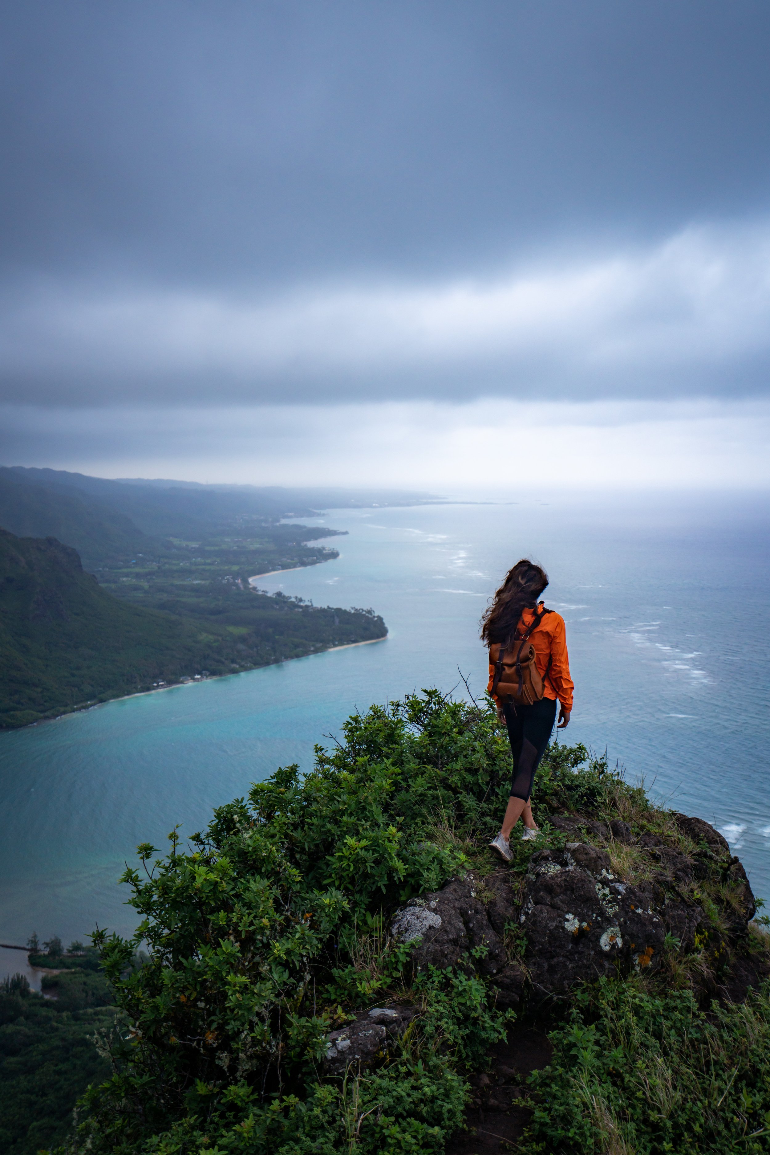
Punuluʻu Valley
Once through the famous Castle Notch, you’ll get one of the best and most expansive views you can find on Oʻahu, granted that you’re hiking on a clear day!
However, I say, enjoy it because it won’t last long!
The traverse to the ridge down continues to the left (straight) of the notch.
Then, after about 0.1 miles (0.2 km) on this traverse, turn right down the most prominent ridge into Punaluʻu Valley.
That said, don’t expect any kind of descent trail, like the rest of the hike up to this point, and if my photos look like there is a path to follow, it’s because I wasn’t leading, as two people before me trampled down the overgrowth.
This is the top of the ridge heading down into Punaluʻu.
Multiple times on the ridge, there will be what look like side trails to follow, like in the photos below.
This may be because Castle historically had seven switchbacks up to the notch, but they are all but lost today! That said, they never appeared to be a good enough path to follow, which is why I suspect the one in the photo below was roped off.
Nevertheless, my best advice is to stay directly on the ridgeline of the biggest, most prominent ridge down into Punaluʻu Valley.
This photo below was climbing down the main ridge to another trail that looked like it was a switchback traversing the side of the valley. It may have been the most prominent looking one, but it never seemed like the best path that we should trust, as if we made a left.
Therefore, we kept following the the ridge.
Somewhere in this area of these last few photos is where we went wrong, and it’s exactly why I say, stay on the main ridge! However, once we made it to the area in the photo below, there was almost no doubt that we were going to drop down into the gulch on the right. It was as if we were too far along to turn around and figure out a better path.
Therefore, when we made the decision to drop down into the stream, we started making our way down to the right. The final down climb was about 50 ft. (15 m), and it definitely had its moments!
However, when we were in the process of figuring out the near-vertical down climb, I think I said, “WTF! There’s a rope! How are we not the first humans in history to ever step foot here?”
Somehow, someway, somebody else got just as off-track as we did and tied a rope to make the final descent. Since we didn’t know how long the rope had been there, we chose not to use it. However, Mark, the first one to climb down, tested his weight on it once in the gulch, and it held! Still, I didn’t rely on it.
One by one, we all made it down, and not a moment too soon because the mosquitoes were horrible!
After meandering on either side of the stream for a while, we finally saw our first signs of life.
Before even going on the hike, I knew that the end of the trail from the notch to the valley floor was going to be a guessing game, so eventually, I was confident we’d hit a road to walk out.
Just before the road, I noticed where the ridge down terminated next to where we walked out through the stream.
That’s why I kept saying, stay on the main ridge, so that you can ideally hike down into the valley on the best gradual slope there is!
I guess this is one reason why the Castle Trail is a one-direction hike from Papali Ridge.
Turn right to exit on Punaluʻu Valley Road.
We staged a car to get back to the Maʻakua-Hauʻula Loop Trailhead.
Alternatively, the bus could be a good option.
Native Plants on the Castle Trail
The upper elevations of Papali Ridge and the Castle Trail are some of my favorite places on Oʻahu to look for native Hawaiian plants.
I think my favorite find on this day was Hulumoa, also called the native Hawaiian Mistletoe, but be on the lookout for ʻAhakea, Kōpiko, ʻŌhiʻa lehua, ʻŌhiʻa ha, various ʻŌhelo species, Kāwaʻu, Kokiʻo Keʻokeʻo, and ʻAkolea, to really only name a few.
If you would like to know more about these and tons of other native Hawaiian plants from across the islands, I encourage you to check out my separate post linked below.
Read My Separate Post: Native Hawaiian Plant Guide