Hiking the Mt. Olomana Trail (Three Peaks) on Oʻahu, Hawaiʻi
Distance (All Three Peaks): 2.9 miles / 4.7 km
The Mt. Olomana Trail on the east side of Oʻahu is a stunningly beautiful hike along the exposed ridges of a standalone mountain above Kailua and Waimānalo that traverses up and down the ridges of three distinct peaks—hence the name 'Three Peaks,' by which the trail is commonly referred to.
That said, the Mt. Olomana Trail is easily one of the best sunrise hikes on Oʻahu, as the panoramic views from the first and second peak are truly speak for themselves when first light hits the cliffs of the Koʻolau Mountains off in the distance!
However, this all goes without mentioning that Mt. Olomana has proved to be one of the deadliest hikes on Oʻahu, which is why I highly recommend reading through this entire post carefully, as it seems that many first-time hikers, eager to climb Three Peaks, are met with challenges and dangerous situations that they did not anticipate.
I hope it goes without saying, but this warning is meant with good intentions, as I have lost a friend myself on a different Hawaiʻi trail.
Mt. Olomana Trailhead Parking
Parking for the Mt. Olomana Trail is best near the Auloa & Loop Road intersection.
DO NOT park on the asphalt that you see in the photos below! I say this because parking tickets are handed out frequently there, as the City of Honolulu considers this a side walk, even if it doesn’t look like one. Furthermore, if any part of your tires are parked on the asphalt, you are gambling with a ticket when you return.
Finally, a little further up Maunawili Road, past the Auloa Road split, is another small dirt parking area on the right-hand side. Again, do not park any part of your car on the asphalt at this spot either.
Google Maps Directions: Mt. Olomana Trailhead Parking
Mt. Olomana Trailhead Break-ins
Break-ins happen often at the Mt. Olomana Trailhead to people who make themselves easy targets, usually visitors who don’t know any better.
Believe me when I say that everything in your car needs to be hidden, and if you can’t hide a valuable, you need to hike with it!
Never leave keys, wallets, passports, etc., even if you can hide it. I promise you that it’s worth carrying the extra weight up the mountain.
Getting to the Three Peaks Trailhead
Since hikers are required to park so far away from the trailhead, you need to walk an additional 0.75 miles (1.2 km) along Loop Road to get to the trailhead.
That said, the real trailhead for Mt. Olomana is located on the Royal Hawaiian Golf Club’s property on the left-hand side of the road.
Hiking the Mt. Olomana Trail
From the start of the trail, not including the walk on Loop Road, the Mt. Olomana Trail is a 2.9 miles (4.7 km) if you choose to hike all three peaks.
Regardless of whether the distance sounds short, the trail is very steep, with an elevation gain of about 1,550 ft. (472 m) in only 1.4 miles (2.3 km) to the first peak.
This first section could take you anywhere from 45 minutes to 2 hours to reach the summit, depending on your pace.
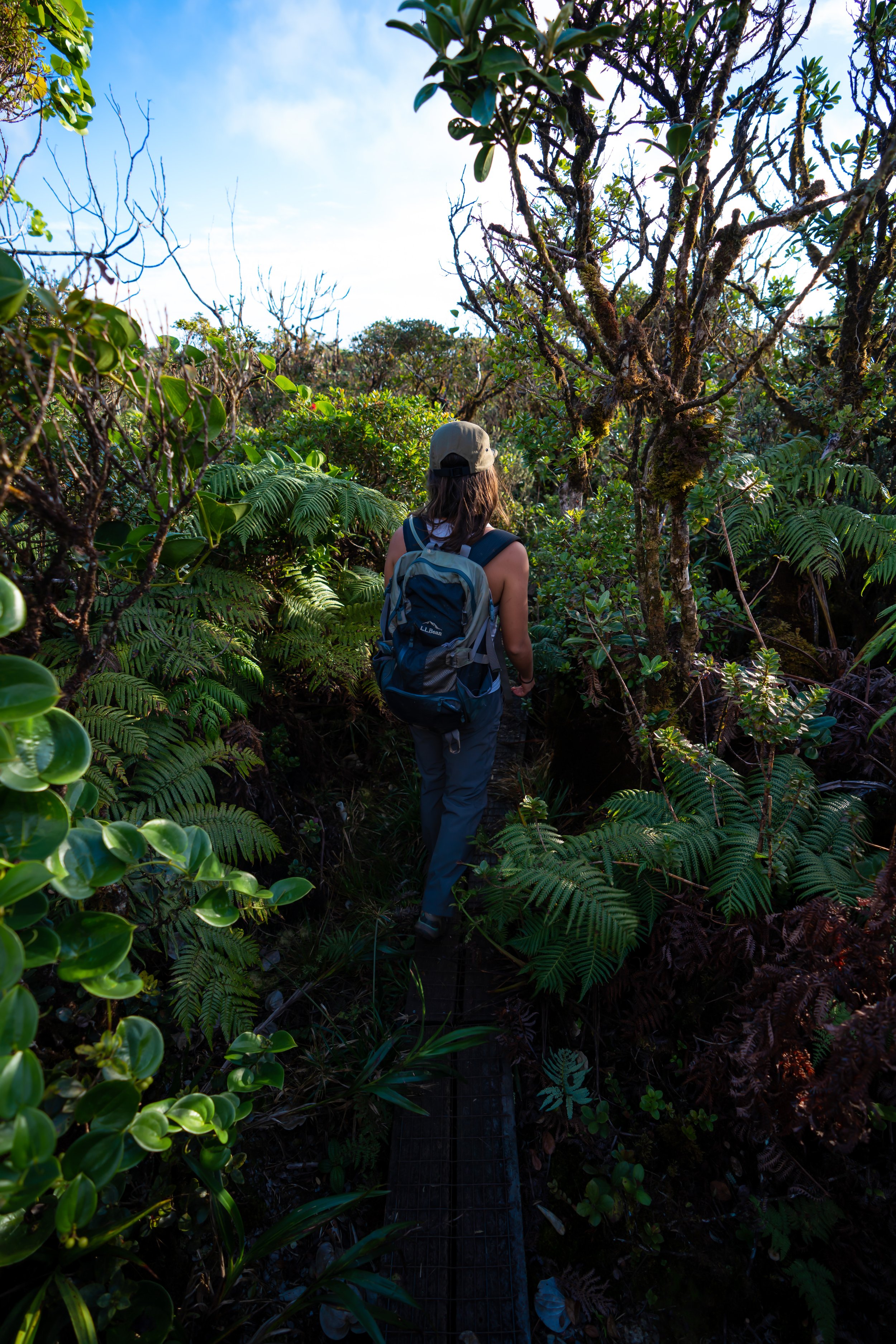
Lower Forest
The beginning of the Mt. Olomana Trail is usually very muddy because of all the rain the east side of Oʻahu receives.
However, the mud usually gets better once on the ridge above the lower forest.
At the split in the photo below, turn right to continue up Mt. Olomana.
Northwest Ridge
Pay close attention to this right turn in the photo above, because when you’re hiking back, this left turn can be very easy to miss, and you might continue straight without realizing it.
I will talk more about what to expect if you miss this turn at the end of the post.
The Northwest Ridge up Mt. Olomana starts off on a steady incline, but it gets steeper and steeper the closer you get to the first peak.
Eventually, much of the trail turns into a scramble, with a lot of ropes, as you make your way up to the climb below the first peak.
First Climb
The first climb in the photos below is the first real challenge on the Three Peaks hike.
Therefore, if you’ve encountered any difficulty up to this point, I recommend turning back, as the trail only gets more challenging the further you go.
In my opinion, the right side of the wall is easier than the left.
Past the first climb, there’s one more tricky section before reaching the first peak.
You can either scramble up the ridge or climb up to the right, which is what’s shown in the photo below.
However, what the photo doesn’t show is consequences of falling on either side, which would almost certainly mean death.
First Peak (Mt. Olomana)
The photo below is the summit of Mt. Olomana, the highest of all three peaks.
Furthermore, the best views are only a short walk ahead, between the second and third peak.
Hiking to the 2nd Peak
From the first to the second peak, the ridge drops down a few hundred feet before climbing back up again.
Note that the section between the first and second peak are still some of the easier parts on the entire hike, and the worst is yet to come.
This is one of my favorite views on the entire trail.
Second Peak (Pakuʻi)
Shortly past the second peak is the drop that leads to the third.
This viewpoint, shown below, is where I strongly encourage most hikers to turn around.
Warning
There’s no easy way to say it, but most hikers are NOT physically capable of hiking from the second to the third peak.
Please read the sign in the photo below, and note how many deaths are concentrated in this small section.
Hiking to the Third Peak (Ahiki)
Everything that you can see heading down off the second peak is not the worst of it. It only gets harder as you go.
Coming from someone who has been to the third peak many times, I can honestly say it’s not worth it!
There are no views worth soaking in. There is no fun with the constant unnecessary exposure, and no achievement in making it to the lowest of all three peaks.
I didn’t even complete the third peak on the day I took these photos because I’m telling you, it’s just not worth it. There are so many better hikes on Oʻahu, most of which are mentioned in this blog.
Overall, it’s just an unnecessary grind where one slip and fall would certainly mean death!
Like I said, what you can see in the photo below is not the worst of it.
Again, as previously mentioned, I didn’t complete the third peak on the day I took these photos, and the important reason why was that I was hiking alone.
The risk of completing the third peak was simply not worth the reward of having photos for this post. Someday I’ll be back with a friend and fill in these photos, but just know that it’s not all it’s cracked up to be.
Hiking Down Mt. Olomana
If you only hiked to the first peak, then down-climbing this section in the photo below is going to be the hardest part of the return hike.
If you chose to hike to the third peak, then the above statement obviously doesn’t apply. The section between the second and the third peak is much longer, with many more technical sections to navigate.
On the hike back, don’t forget to make the left-hand turn off the ridge.
What Happens if you Miss the Left Turn?
If you end up going straight instead of making the left turn, you will still make it back to Loop Road in a very complicated way.
Going straight will take you down the ridge for a while until you reach this old abandoned and neighborhood. The trail will be easy enough to follow at first, but when you make it to the neighborhood, you may want to use your phone GPS to guide you back to the road.
When you pop out of the forest back onto Loop Road, you should end up near the golf course gate. It’s obviously not the best way to go, but it will get you out of there.
Hiking Mt. Olomana for Sunrise
Mt. Olomana is an incredible sunrise hike, but if that is your goal, know that the golf course guard has been known to turn away hikers as early as 5:30 a.m. If they see you, they will not let you begin your hike until 6:00 a.m., essentially making you too late to see the sunrise.
To be safe, especially if you’ve never done it before, I would plan for a start well before 5:30 a.m. to ensure you make it up in time and not get turned away.
This is especially true in the summer when sunrises are earlier!
Native Plants on the Mt. Olomana Trail
Relatively speaking, Mt. Olomana is a low-elevation trail for Hawaiʻi, meaning that most of the plants along the trail are non-native/ invasive species.
One of the few exceptions that I saw on the trail is Hau in the lower forest and Hōʻawa on the ridge.
If you would like to learn more about these and many other native Hawaiian plants from across the islands, I encourage you to check out my separate post linked below.
Read My Separate Post: Native Hawaiian Plant Guide