Hiking the Mokulēʻia Trail on the North Shore of Oʻahu, Hawaiʻi
Distance (RT via Mokulēʻia Access Road Gate): 14.3 miles / 23.0 km
Distance (RT Way via Peacock Flats): 7.1 miles / 11.4 km
Distance (RT via Mokulēʻia TH): 5.6 miles / 9.0 km
The Mokulēʻia Trail in the Waiʻanae Mountain Range on Oʻahu is a little-known day hike near Peacock Flats Campground that winds its way through a beautiful dryland native Hawaiian forest, ultimately ending at a panoramic overlook above Oʻahu’s North Shore!
That said, I say 'little-known' because, much like the Kuaokalā Trail located just to the west, the Mokulēʻia Trail is one of a few day hikes on the island where the trailhead begins high in the mountains, making the trail’s access seem more intimidating than other North Shore adventures, such as the Kaʻena Point Trail or the Kaunala Trail in Pūpūkea.
What this really means is that hiking the Mokulēʻia Trail involves choosing between one of two options in order to access the trailhead. The first and easiest option is to hike the trail while camping at Peacock Flats or with a day-use permit. This takes away the need to hike to the trailhead from Oʻahu’s North Shore.
However, the second and more practical option is to hike the 3.6-mile (5.8 km) Mokulēʻia Access Road from the North Shore, as this trailhead doesn’t require any advanced planning, which is why it’s the option that I recommend—not to mention, the Access Road is easier than the distance may make it seem.
All of this to say, the roundtrip distance from the North Shore is 14.3 miles (23.0 km), but like most Hawaiʻi adventures, I think the distance is a bad indicator when it comes to determining difficulty, as the Mokulēʻia Trail is one of just a few cases where I think the distance deceivingly makes the Mokulēʻia Trail seem harder than it actually is.
How Long is the Mokulēʻia Trail?
Since the Mokulēʻia Trail can vary in distance depending on where you decide to begin and far you decided to hike, I wanted to break down the one-way distances starting from the Mokulēʻia Access Road Gate on the North Shore of Oʻahu.
Mokulēʻia Distances (One Way):
Mokulēʻia Access Road Gate to Peacock Flats: 3.6 miles (5.8 km)
Peacock Flats to Mokulēʻia Trailhead: 0.75 miles (1.2 km)
Mokulēʻia Trailhead to Mokulēʻia Shelter: 0.8 miles (1.3 km)
Mokulēʻia Shelter to Mokulēʻia Overlook: 2.0 miles (3.2 km)
Total Distance (One Way): 7.15 miles (11.5 km)
Mokulēʻia Trailhead Parking
Parking for the Mokulēʻia Trail depends entirely on which route you choose to begin.
First, there is the option to start at the Mokulēʻia Access Road Trailhead off Farrington Highway on the North Shore of Oʻahu. Alternatively, with a valid day-use or overnight permit for Peacock Flats, hikers can drive up to the Kaʻena Point Tracking Station on the West Side and park at the Mokulēʻia Trailhead in the Waiʻanae Mountains.
A high-clearance 4WD vehicle is required to drive to the trailhead from Kaʻena Point.
Google Maps Directions: Mokulēʻia Access Road / Mokulēʻia Trailhead
Hiking the Mokulēʻia Trail
Peacock Flats Campground
This article begins at the top of the Mokulēʻia Access Road, as the road from the North Shore is almost always my preferred route to reach the Mokulēʻia Trail, as both the long drive out to the West Side and getting a permit can be avoided by starting at the gate off Farrington Highway.
If you would like to learn more about the Mokulēʻia Access Road to get to this point, all the details can be found in my separate post linked below.
Read My Separate Post: Mokulēʻia Forest Reserve Access Road
To skip ahead to the Mokulēʻia Trailhead, click here.
Mokulēʻia Trail Access Road Junction
After the gate at the top of the Mokulēʻia Access Road, the hike to the Mokulēʻia Trail begins at Peacock Flats on Mokulēʻia Trail Access Road.
At this split after the gate, go left to follow Mokulēʻia Trail Access Road for the next 0.75 miles (1.2 km) to the true Mokulēʻia Trailhead.
If you are interested in camping at Peacock Flats and accessing the Mokulēʻia Trail by car, reservations can be made using the link below, with weekdays being much easier to reserve than weekends.
Book Here: Peacock Flats Campground
This is where Mokulēʻia Trail Access Road leaves Peacock Flats behind.
That said, signs and maps often label this section as the Mokulēʻia Trail, but the actual trail does not begin until another 0.6 miles (1.0 km) past this point.
From the start of Mokulēʻia Trail Access Road at Peacock Flats, the hike will gain roughly 350 ft. (107 m) over the first 0.75 miles (1.2 km) to the true Mokulēʻia Trailhead, which isn’t all that steep compared to certain sections on the hike up the Access Road in order to reach the forest reserve.
For the most part, there isn’t much to know about the hike to the Mokulēʻia Trailhead, as there aren’t many side trails or alternative paths to get off track.
Kukui is one of many canoe plants in the Mokulēʻia Forest Reserve, meaning a human introduction when Hawaiʻi was first discovered by the Polynesians.
Mokulēʻia Trailhead Parking
This is where Mokulēʻia Trail Access Road reaches the Mokulēʻia Trailhead parking area after 0.75 miles (1.2 km) of hiking since leaving Peacock Flats.
Mokulēʻia Trailhead
After almost 4.4 miles (7.1 km) from the Mokulēʻia Access Road Gate off Farrington Highway on Oʻahu’s North Shore, the true Mokulēʻia Trail finally begins!
That said, everything mentioned thus far can be cut out by either planning to camp at Peacock Flats or getting a day-use permit through the Hawaiʻi State Department of Land and Natural Resources (DLNR), linked below.
Book Here: Mokulēʻia—Kuaokalā Day-Use Permit
After leaving the road behind, the Mokulēʻia Trail begins a long contour trail below the crest of the Waiʻanae Summit Trail (WST).
This is why I often say that no part of the Mokulēʻia Trail is part of the WST for those trying to make the summit count.
Instead, the Mokulēʻia Trail is, at best, an access trail, which only reaches the connection with the Waiʻanae Summit Trail at the Mokulēʻia Shelter, about 0.8 miles (1.3 km) into the hike.
Upper Kapuna Management Unit
After just 0.1 miles (0.2 km), the Mokulēʻia Trail passes through an ungulate-exclusion fence for the Upper Kapuna Management Unit within the Pahole Natural Area Reserve.
After passing through, please be sure to close this and all gates, as restoration work in this part of the Waiʻanaes is always ongoing.
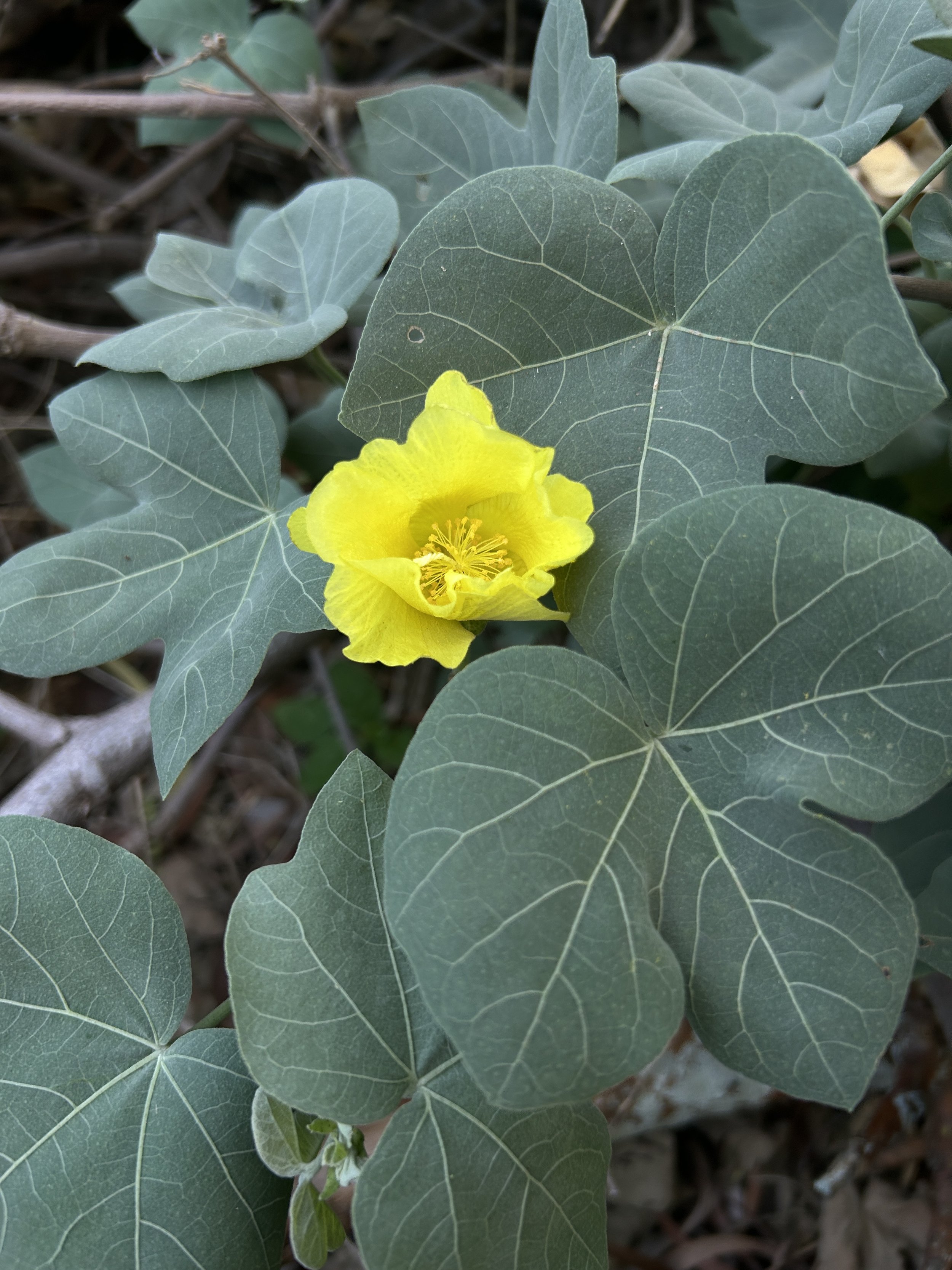
Immediately after entering the management unit, the Mokulēʻia Trail enters a beautiful dryland native Hawaiian forest, filled with an abundance of different endemic species that conservationists are always working to revive in the fight against non-native, invasive species, like Strawberry Guava.
This is why I have highlighted so many of native species below, but in reality, the photos I’ve included only scratch the surface of how many there truly are!
This Loulu palm is endemic to the Waiʻanae Mountains on Oʻahu, hence its name after Mt. Kaʻala.
For much of the hike to the Mokulēʻia Shelter, the Mokulēʻia Trail winds its way through a predominantly non-native Strawberry Guava–Christmas Berry forest, with only patches of forest carved out for native restoration.
This is an example of one of the many small patches carved out in the fight against invasive species, but hopefully, in time, more of the trail can return to what it once was!
Olopua is one of the most common and widespread dry forest species across Hawaiʻi, and it is commonly found in some of the few remaining patches of dryland forest across the state, such as the Kānepuʻu Preserve on Lānaʻi.
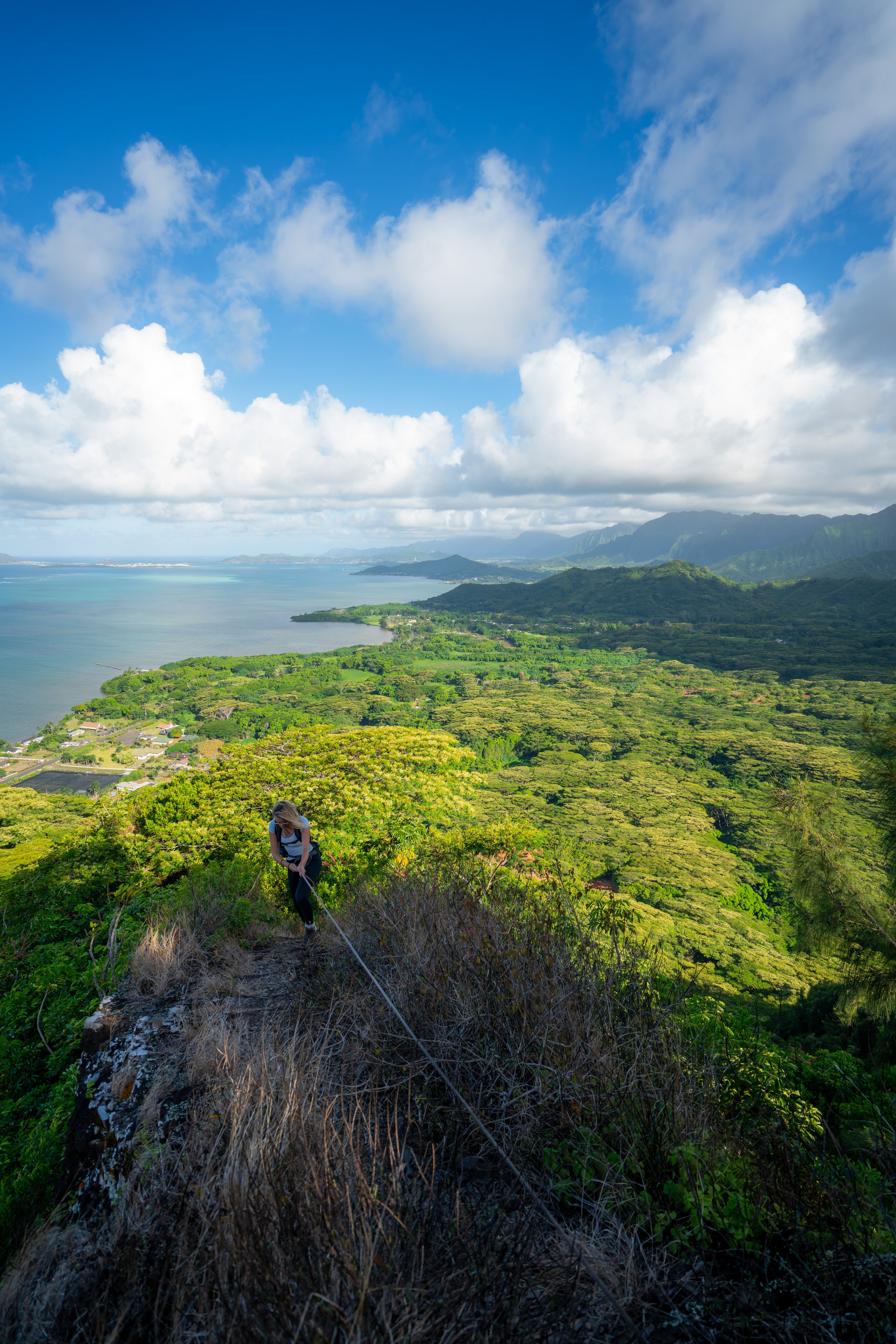
This bench is a nice sign that the Mokulēʻia Shelter is not far ahead!
This is the view looking east across the Waiʻanae Mountains toward Mt. Kaʻala.
Lama, or Ēlama, is another common dry forest native species in Hawaiʻi, similar to Olopua mentioned above.
Mokulēʻia Shelter (Mokulēʻia-Waiʻanae Summit Junction)
After roughly 0.75 miles (1.2 km), the Mokulēʻia Trail reaches the Mokulēʻia Shelter, which is also the junction for the Waiʻanae Summit Trail and the Mokulēʻia Bench.
That said, the Mokulēʻia Shelter and nearby viewpoint are usually as far as most people hike, but to reach the North Shore overlook at the very end, go straight at this junction to continue on the Mokulēʻia Trail.
Read My Separate Post: Waiʻanae Summit Trail (WST)
I think it’s worth mentioning again that the Mokulēʻia Trail is not part of the WST.
After the Mokulēʻia Shelter, the Mokulēʻia Trail becomes far less trafficked compared to the first 0.75 miles (1.2 km) leading to this point.
However, the trail past the shelter is still very straightforward and only becomes difficult to follow at the very end in the Eucalyptus forest, just before the overlook itself.
Just after the clearing and the Mokulēʻia Shelter, Palapalai can be found in abundance among the invasive Wood Ferns that also surround the trail.
One of the cool things about the Mokulēʻia Trail is that hikers can see two of the most common endemic Hāpuʻu ferns growing directly alongside the trail—even alongside one another!
That said, telling the two most common species apart can be challenging, unless you know the little trick described below!
Cibotium glaucum vs. Cibotium chamissoi
There are subtle differences in the pinnae that can be hard to describe, but for a quick, easy way to determine which species you’re looking at, flip the fronds!
The underside of Cibotium glaucum will look pale/ light green, while Cibotium chamissoi will be a distinct green color (not pale).
After the Mokulēʻia Shelter, the Mokulēʻia Trail begins a very drawn-out descent to the overlook at the end of the hike.
By this, I mean that the Mokulēʻia Trail descends roughly 710 ft. (216 m) over the final 2.0 miles (3.2 km) to the Mokulēʻia Overlook, which really only becomes noticeable on the hike to the shelter on the way back.
Just steps after the Hāpuʻu species shown above, the Mokulēʻia Trail passes Cibotium chamissoi.
What hopefully stands out, compared to the first one shown above, is how much greener the undersides of the fronds are—and yes, the difference is subtle, but the more you hike and practice identifying Hawaiʻi’s Hāpuʻu ferns, the easier it becomes to tell the difference!
On the hike back, this hard switchback is a nice mental checkpoint that the Mokulēʻia Shelter is only 0.25 miles (0.4 km) away.
Kapuna Gulch
This is the bottom of Kapuna Gulch, the first of two major gulches on the Mokulēʻia Trail before the overlook at the end.
Māmaki is a very common native along the Mokulēʻia Trail, but if you are curious about trying the native Hawaiian Māmaki tea, I kindly ask that you don’t harvest Māmaki from our native forests.
Instead, Māmaki can be bought from one of the local reputable vendors listed below.
After Kapuna Gulch, the Mokulēʻia Trail climbs up and over Keawapilau Ridge, at which point it begins working its way down into Keawapilau Gulch just before the Eucalyptus forest at the end.
Keawapilau Ridge
This is the first of three separate times past the Mokulēʻia Shelter where the Mokulēʻia Trail crosses an ungulate-exclusion fence, with the third located just a short distance before the overlook at the end.
This is where the descent into Keawapilau Gulch more noticeably begins.
Keawapilau Gulch
This is the bottom of Keawapilau Gulch, where the Mokulēʻia Trail then begins to wind its way over to the Eucalyptus forest that dominates the second half of the hike past the shelter.
This is where the Mokulēʻia Trail transitions to a towering overstory Eucalyptus forest, which will dominate the remaining 1.2 miles (1.9 km) from this point to the overlook at the end.
Unlike the rest of the Mokulēʻia Trail up to this point, the sections through the Eucalyptus trees at the end are often quite vague.
That said, expect a lot of fallen branches and possibly trees, as trail maintenance is quite seldom this far out, and I say this from countless hikes over many years up in the Mokulēʻia Forest Reserve.
This is the second of three times the Mokulēʻia Trail crosses an ungulate-exclusion fence before the North Shore overlook.
For those who enjoy trail running, these final sections will likely prove to be the most difficult, but if you don’t mind obstacles, I think the trail can be quite fun!
If you happen to be looking at a moody, cloudy day when planning the Mokulēʻia Trail, I would not let that discourage you from heading up into the Waiʻanaes, as I often reminisce about one windy, overcast day up here in the Eucalyptus trees, when the clouds made this forest so dark, quiet, and peaceful!
That day became one of my favorite memories and one of many reasons why I enjoy this part of the island so much—especially when Seven Brothers in Haleʻiwa is planned for dinner after making it back down!
This is the third and final time the Mokulēʻia Trail crosses an ungulate-exclusion fence before the overlook, and it’s where it leaves the Upper Kapuna Management Unit behind.
At the third fence, hike up the hill to find a gate that leads to the other side.
If there’s one thing I hope these photos show more than anything else, it’s how much deadfall exists both on and off the trail, which often feels like it’s cleared by the community rather than by official trail maintenance from the state.
These two fallen Eucalyptus trees are always a nice sign that the Mokulēʻia Trail is not far from the final ridge that leads down to the Mokulēʻia Overlook at the end of the hike!
This is where the Mokulēʻia Trail turns the final corner toward the ridge that leads down to the overlook.
This is where the Mokulēʻia Trail leaves the contour trail along the hillside behind and begins following the ridge down to the overlook.
That said, go left at this point to continue toward the end of the trail.
As for the overgrown, forgotten path heading right, I have followed it before, but I have no idea what it was for or when it was built, except that it seemingly heads east toward West Mākaleha.
Once on the ridge, simply follow the most obvious path heading north, and know that some of the final sections ahead are extremely vague as the Mokulēʻia Trail nears the end.
It is quite remarkable that this is considered a Nā Ala Hele trail, the same as others on Oʻahu, like Kuliʻouʻou Ridge and Mānoa Falls.
This is where the Mokulēʻia Trail begins the final descent to the overlook, just 0.1 miles (0.2 km) from this point.
This clearing is arguably the most confusing part of the entire Mokulēʻia Trail, as the thick overgrowth on the ridge blocks the best viewpoint immediately thereafter.
Once here, stay on the ridge and look for the best path you can find through the branches and tall grass.
I can only hope that more traffic might make this final section more clear!
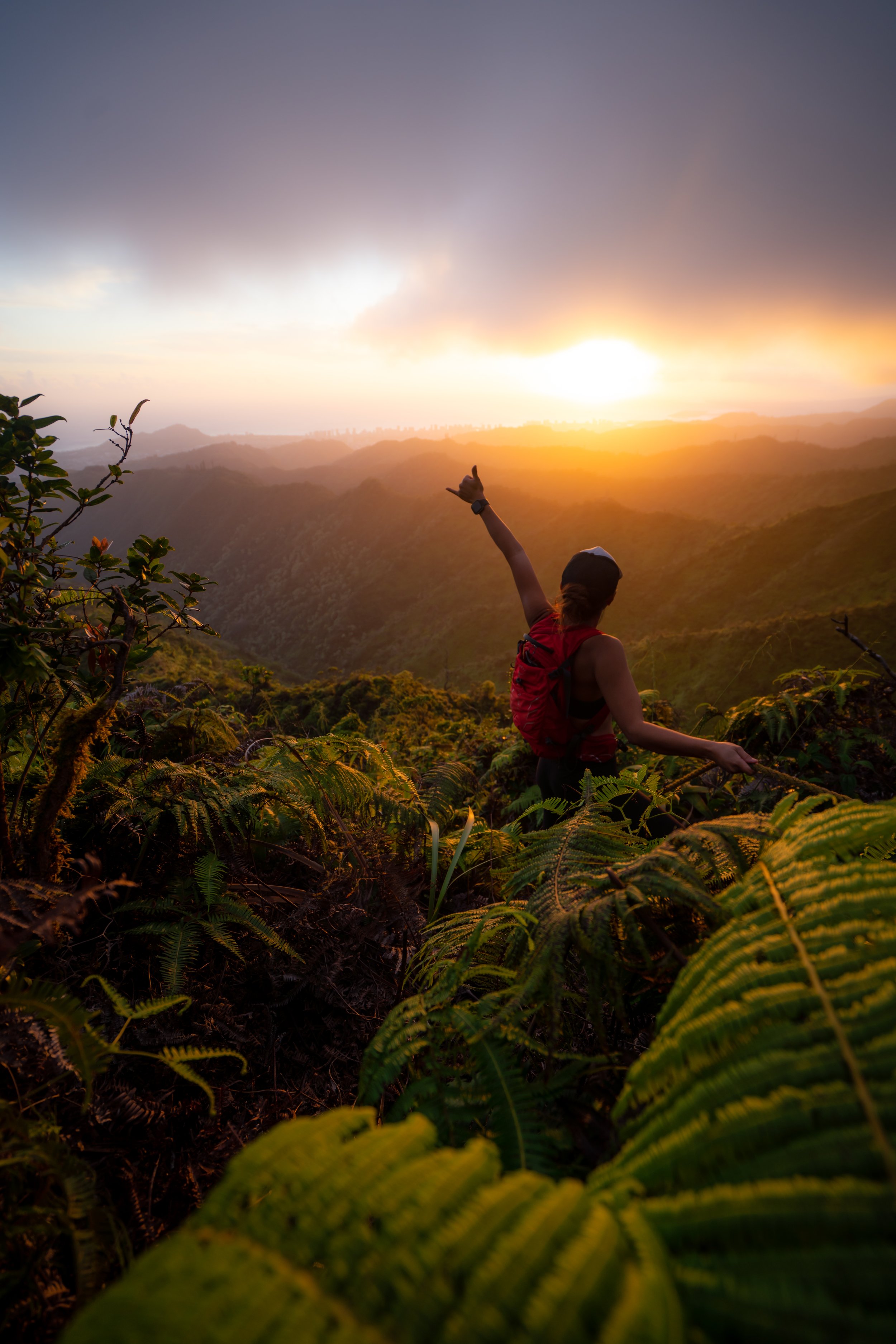
Mokulēʻia Overlook
This large erosion scar is the end of the Mokulēʻia Trail, and it’s a viewpoint toward both Oʻahu’s North Shore and Mt. Kaʻala to the east that few ever see!
For this reason, both the Mokulēʻia Access Road and Trail make for one of my favorite trail runs on Oʻahu, but in reality, the Mokulēʻia Trail is just one of many different routes one could take from Peacock Flats when you begin to learn how vast the Mokulēʻia Forest Reserve really is!
To learn more about about the topic, I encourage you to check out my separate post below. Additionally, if you’re in need of a good road-to-trail shoe, you can see my preferred shoes linked below, which are truly perfect for an adventure on both the road in the beginning and the trails up in the forest reserve!
Read My Separate Post: Best Trail Runs on Oʻahu
Native Plants on the Mokulēʻia Trail
Since the Mokulēʻia Trail is both higher in elevation and more heavily managed than many other Oʻahu day hikes, considering all the different pockets of native forest scattered throughout, there are tons of different native Hawaiian plants to see along the way!
Some of these include Hōʻawa, ʻŌhiʻa lehua, Alani, Mēhamehame, Maile, Kōpiko, Haʻiwale, Pānaunau, Māmaki, Pāpala Kepau, and Ōpuhe, to name only a few.
If you are curious about trying the native Hawaiian Māmaki tea, I kindly ask that you don’t harvest Māmaki from our native forests but, instead, buy from one of the local reputable vendors, such as those listed below.
If you would like to learn more about these and many other native Hawaiian plants from across the islands, I encourage you to check out my separate post linked below.
Read My Separate Post: Native Hawaiian Plant Guide