Hiking the ʻIliahi Ridge Trail on Oʻahu, Hawaiʻi
Distance: 6.2 miles / 10.0 km
The ʻIliahi Ridge Trail in central Oʻahu is an alternative day hike off the long Mānana Ridge Trail that can make for a great adventure when you want a moderate challenge without the difficulty of climbing all the way to the Koʻolau Summit.
By this, I mean that the full ʻIliahi Ridge loop is more of a workout than it may initially seem, as the trail descends steeply not once, but twice, down to the Mānana Stream in order to connect the two sides of the hike together.
That said, a common sentiment along hikers is that trail is too overgrown, and while it entirely depends on how much traffic and maintenance ʻIliahi Ridge has received, I can confidently say that the trail is not the nearly the most difficult trail on the island in terms of overgrowth.
In fact, the overgrowth is quite negligible, so long as you wear good hiking pants to help with the Uluhe ferns.
The pants below are my recommendations that hold up the best with the overgrowth here in Hawaiʻi, but with any hiking pants that need to be durable, make sure that they are at or near 100% nylon. This is really the most important factor!
ʻIliahi Ridge Trailhead Parking
Parking for the ʻIliahi Ridge Trail is located at the very top of Komo Mai Drive in Pearl City, the same trailhead that also serves Mānana and Waimano Falls.
It is for this reason that finding parking near the trailhead can be difficult—especially on a weekend or holiday!
Google Maps Directions: ʻIliahi Ridge Trailhead
Hiking the ʻIliahi Ridge Trail
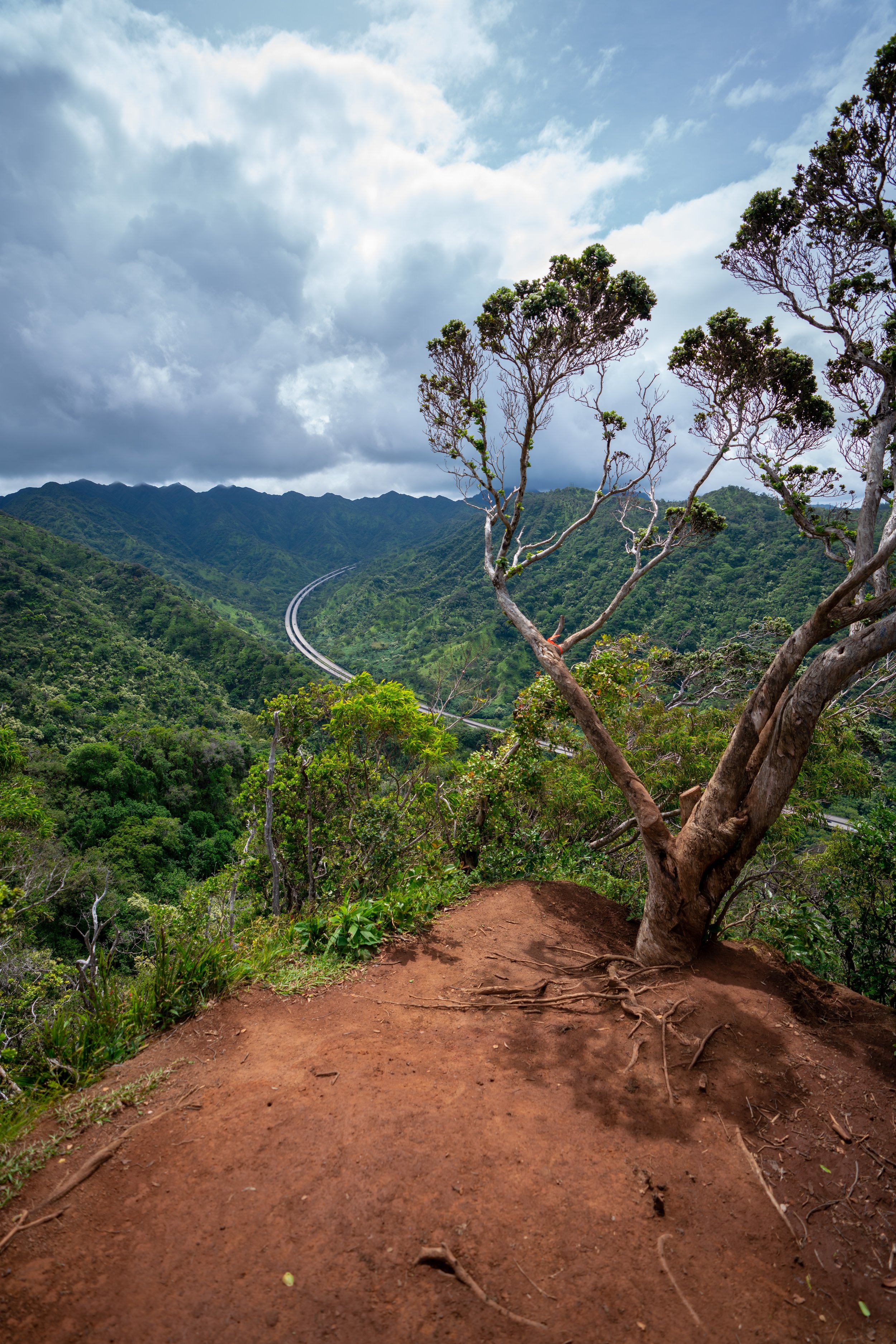
The ʻIliahi Ridge Trail begins at the Mānana Ridge Trailhead at the top of Komo Mai Drive and follows the Mānana Ridge Trail for the first 0.3 miles (0.5 km), where it then branches off the ridge to begin the steep descent over to ʻIliahi Ridge.
The Mānana Ridge Trail to ʻIliahi Ridge begins on a paved service road, which it will follow for the entire hike up to the split off the state-managed trail.
This first set of power lines is not the beginning of ʻIliahi Ridge, but there are beautiful views just up the hill off the trail!
Lower ʻIliahi Ridge-Mānana Ridge Junction
After about 0.3 miles (0.5 km), the Mānana Ridge Trail reaches the first of two junctions with the ʻIliahi Ridge Trail.
That said, it entirely depends on whether you want to go up or down ʻIliahi Ridge, but I personally recommend taking the first junction, because I think ʻIliahi makes for a more beautiful clockwise hike than in reverse.
Read My Separate Post: Mānana Ridge Trail
Regarding my thoughts above, I chose to go left to begin the steep descent on the ʻIliahi Ridge Trail to the Mānana Stream.
Eventually, the trail down into the gulch will make this hard left turn to continue down a set of switchbacks immediately following.
Mānana Stream
Once at the Mānana Stream, go left to follow the trail downstream for a short distance to find the trail that climbs back up on the other side.
This is the first of two stream crossings on the ʻIliahi Ridge Trail.
Almost immediately after the stream crossing, the ʻIliahi Ridge Trail will come to this split.
Go right to stay on the most straightforward path. The trail to left can also be taken, but it is not as straightforward as the trail to the right.
You will know you’re on the correct trail because it should start climbing out of the gulch almost immediately after the previous split.
When the trail reaches the ridge on the far side of the stream, go right to continue up to ʻIliahi Ridge.
This section will remain fairly steep, as the trail out of the gulch climbs nearly 460 ft. (140 m) in just 0.4 miles (0.6 km), from the stream to the crest of the ridge.
At this next split, go right to continue up the shortest path to ʻIliahi Ridge.
ʻIliahi Ridge
Once on ʻIliahi Ridge, you may notice a number of trails leading in a number of different directions, but the correct trail is the one that hugs the right side of the ridge closest to the Mānana Stream.
At this next split, go right once again.
This is the point when ʻIliahi Ridge narrows down to just one trail that continues further up the Koʻolau Mountains.
I think it’s worth noting that I’ve seen the best of ʻIliahi Ridge and the worst of ʻIliahi Ridge in terms of overgrowth.
That said, these photos were taken after a group of volunteers recently put a lot of work into the trail to cut back the Uluhe. A trail this clear will not always be the case.
For this reason, I recommend planning for the worst and hoping for the best by wearing good hiking pants, as the ʻIliahi Ridge Trail can be a much less enjoyable hike, as previously mentioned, should you choose to wear shorts.
For obvious reasons, the ʻIliahi Ridge Trail gets its name from the many ʻIliahi trees that can be found along the hike.
To this point, the ʻIliahi Ridge Trail is one of the most pristine mixed Koa-ʻIliahi forests on the island. Therefore, I ask that you please do everything you can minimize your impact, as this species can only be found on the island of Oʻahu.
This view is one of my favorite sections on the ʻIliahi Ridge Trail.
ʻIliahi Ridge Summit
The photo below is the summit of the ʻIliahi Ridge Trail, and it’s where the loop turns back to begin the descent down to the Mānana Stream.
Initially, the hike back down to the Mānana Stream starts off gradually, but it gets a bit steeper toward the bottom of the gulch.
Toward the bottom of the descent, the ʻIliahi Ridge Trail drops down this steep section, which can be quite slippery.
For this section specifically, you may want to consider packing a rope, especially if Oʻahu has been experiencing a lot of wet weather.
Once at the bottom of the gulch, it may seem like the trail should turn to the right to go 'downstream', but in reality, you want to go left to continue toward the Mānana Stream.
That said, this upper section in the gulch is a bit longer, at roughly 0.3 miles (0.5 km), than the lower stream crossing described previously.
This is all without mentioning that the mosquitoes alone in these lower sections should encourage you to wear pants and a long-sleeve sun shirt if the overgrowth did not!
Mānana Stream
After about 0.3 miles (0.5 km) in the gulch, the ʻIliahi Ridge Trail finally reaches the Mānana Stream, where the trail back up to Mānana Ridge is located on the far side.
Upper ʻIliahi Ridge-Mānana Ridge Junction
The open, grassy area in the photo below is at the top of the ridge, overlooking the Mānana Stream adjacent to the Mānana Ridge Trail.
Here, go right to continue back down the well-trafficked Mānana Ridge Trail in order to complete the entire 6.2-mile (10.0 km) ʻIliahi-Mānana Ridge Loop.
Read My Separate Post: Mānana Ridge Trail
Mānana Ridge-Waimano Falls Junction
At about half way down Mānana Ridge, the ʻIliahi Loop passes by the junction for Waimano Falls on the left.
Go straight to continue back to the Mānana Ridge Trailhead.
Read My Separate Post: Waimano Falls Trail
This first set of power lines on the hike back is not the original ʻIliahi Ridge junction.
Lower ʻIliahi Ridge-Mānana Ridge Junction
This is second set of power lines on the hike back is the same ʻIliahi Ridge Trail split from earlier that began the descent down into the gulch.
Native Plants on the ʻIliahi Ridge Trail
The ʻIliahi Ridge Trail is obviously called ʻIliahi Ridge for a good reason, as the trail has one of the highest-density ʻIliahi forests that I’ve come across on Oʻahu.
That said, I noticed the first ʻIliahi tree at about 1.75 miles (2.8 km) into the trail, and I didn’t stop seeing them until a short distance down Mānana Ridge on the return loop.
Furthermore, other native plants that can be found include Koa, ʻŌhiʻa lehua, Uluhe, and Kōpiko, to truly only name a few.
If you’re interested in learning more about these and tons of other native Hawaiian plants from across the islands, I encourage you to read more in my separate post linked below.
Read My Separate Post: Native Hawaiian Plant Guide