Hiking the East Lāhainā Pali Trail (Windmill Hike) on Maui, Hawaiʻi
Distance: 5.0 miles / 8.0 km
Elevation Gain: 1,375 ft. (411 m)
The East Lāhainā Pali Trail on Maui is a moderately challenging day hike in the West Maui Mountains that follows the path of a historic 1800s-era road that once connected West Maui to Māʻalaea and the central valley.
That said, the East Lāhainā Pali Trail is really just one half of this historic route, and it’s often the less-popular half compared to the West Lāhainā Pali Trail, which largely has to do with the panoramic views of the ocean, Kahoʻolawe, and Lānaʻi that can be seen from the other side.
However, I personally think that both the east and west side of the Lāhainā Pali Trail have advantages over the other for a variety of different reasons, which is why I highly recommend reading my breakdown of the two routes to the windmills on Kealaloloa Ridge in the section below.
Lāhainā Pali Trail - East vs. West
Historically speaking, parts of the Lāhainā Pali Trail were part of the King’s Highway (Alaloa o Piʻilani), a 138-mile (222 km) route that circled much of Maui. This route was later improved in the early to mid-1800s to create an overland road connecting West Maui to the central valley, which is what much of the modern 4.8-mile (7.7 km) Lāhainā Pali Trail follows today.
That said, this 4.8-mile (7.7 km) route is the one-way distance from Māʻalaea on the east side to Ukumehame on the west. However, most who venture up the trail only hike one half or the other, since both sides lead to the same place on Kealaloloa Ridge.
This is all to say that I recommend against using the small differences in distance or elevation gain to decide between the two. Instead, I recommend relying on my thoughts about each half described below.
East Lāhainā Pali Trail
First and foremost, I believe that each half of the Lāhainā Pali Trail is better for different reasons—the first of which is the time of day.
By this, I mean that I believe the east side is better as a morning hike, while the west side is better as an evening hike.
I say this because I think the eastern half and the central valley are the most beautiful with the early morning light, which is also when I believe the best photos can be taken on this side.
However, what’s perhaps even more important to mention is that the southwest side of the West Maui Mountains is very hot and dry, meaning if you’re looking to escape the heat but still enjoy the views, starting early on the East Lāhainā Pali Trail is the way to go!
On a different note, the East Lāhainā Pali Trail is the better half of the hike to see various native Hawaiian plants, which I suspect has to do with the fact that it’s on the windward side of Kealaloloa Ridge, unlike the west.
West Lāhainā Pali Trail
Regarding my first statement above, the West Lāhainā Pali Trail is a better evening hike, which I largely believe because it makes for one of the best, easy sunset hikes on Maui!
However, it’s important to understand that starting the West Lāhainā Pali Trail in the mid- to late-afternoon hours will almost always be very hot, and there’s really no way around this if you want to hike as high as the windmills on Kealaloloa Ridge.
Now, this is not to say that it’s necessary to hike as high as the windmills to watch the sunset, but in fact, some of the best places to enjoy it are within 0.5 miles (0.8 km) of the trailhead in Ukumehame, because the West Lāhainā Pali Trail is very close to the water and climbs quickly over a short distance.
On account of this, the West Lāhainā Pali Trail is the best hike on Maui to enjoy the whales from shore during Hawaiʻi’s winter season (mid-December to mid-April), with peak activity occurring from January to March.
All this to say, I hope this makes it clear why each side of the Lāhainā Pali Trail is better for different reasons, which, again, is why I wouldn’t let the short 0.4-mile (0.6 km) difference be the deciding factor between the two.
Read My Separate Post: West Lāhainā Pali Trail
East Lāhainā Pali Trailhead Parking
The East Lāhainā Pali Trailhead is located just off Honoapiʻilani Highway in the southbound direction.
This means that if you’re driving north from Lāhainā or Māʻalaea, you’ll have to make a U-turn to turn off the highway in order to reach the trailhead just up the hill.
Google Maps Directions: East Lāhainā Pali Trailhead
Hiking the East Lāhainā Pali Trail
The East Lāhainā Pali Trail begins on a relatively easy, mostly flat path, but it doesn’t take long for the trail to begin climbing.
This turn is where the East Lāhainā Pali Trail noticeably begins its steep ascent, which does not reach a flatter section for roughly the next 0.8 miles (1.3 km) at the 1.0-mile (1.6 km) mark.
ʻUhaloa is one of the few native Hawaiian plants that thrives in hot, dry landscapes, like the Lāhainā Pali Trail.
Some hikers may want to use trekking poles on the steep East Lāhainā Pali Trail, which can also be useful on the West Lāhainā Pali Trail and the renowned Waiheʻe Ridge Trail.
The one thing I hope these photos make obvious, more than anything else, is just how little shade there is on the Lāhainā Pali Trail, which is also true of either half.
This is why I highly recommend hiking the trail in a hooded sun shirt, and I also recommend steering clear of the trail midday, as the typically very sunny, hot weather is nothing to take lightly on the leeward side of Maui.
This sharp switchback is a nice sign that there is only 0.3 miles (0.5 km) left before the steepest sections East Lāhainā Pali Trail are over!
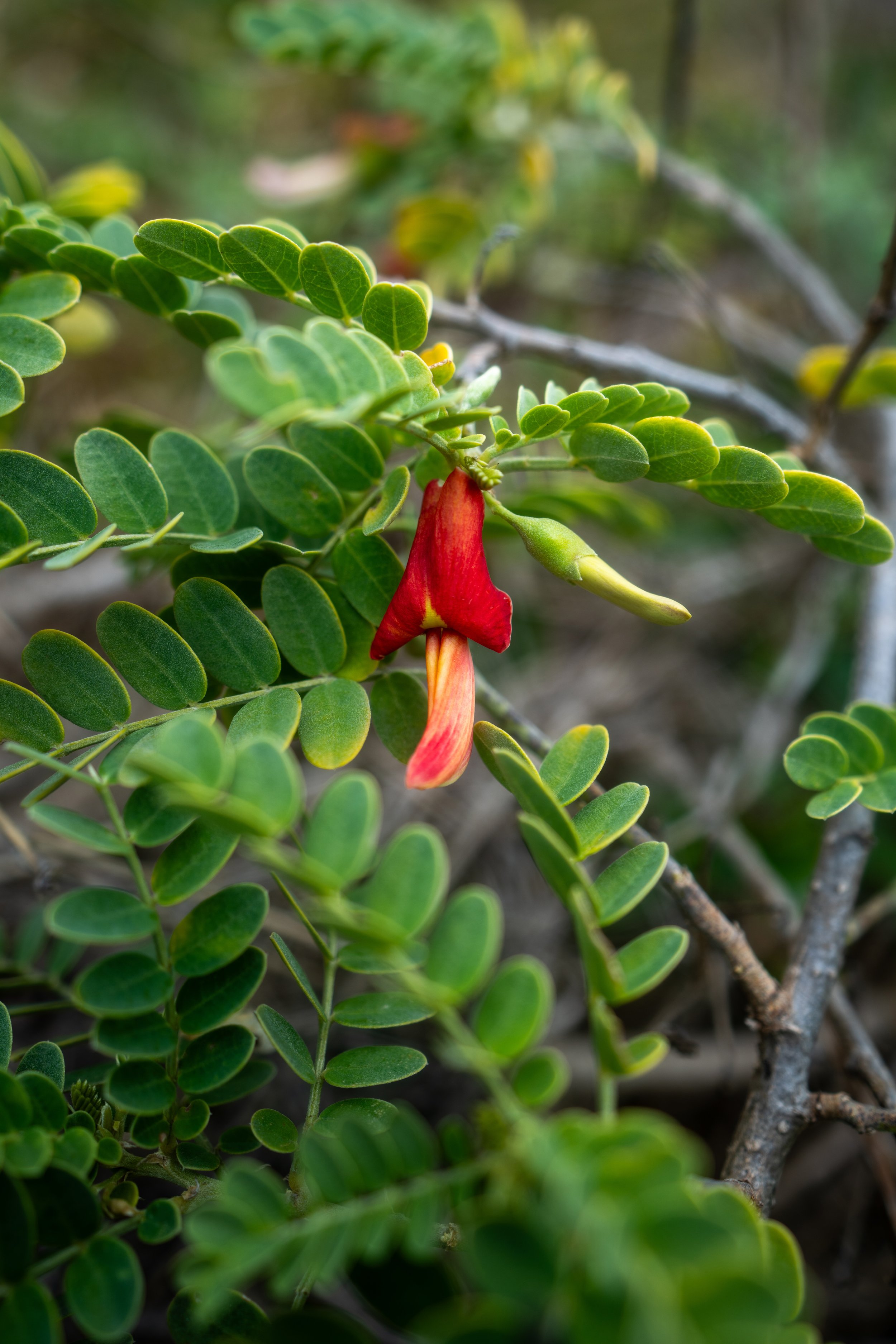
As the East Lāhainā Pali Trail approaches the 1.0-mile (1.6 km) mark, a number of native Hawaiian plants, including ʻAʻaliʻi, Pua Kala, ʻĀkia, and ʻIliahi, can be seen along the trail.
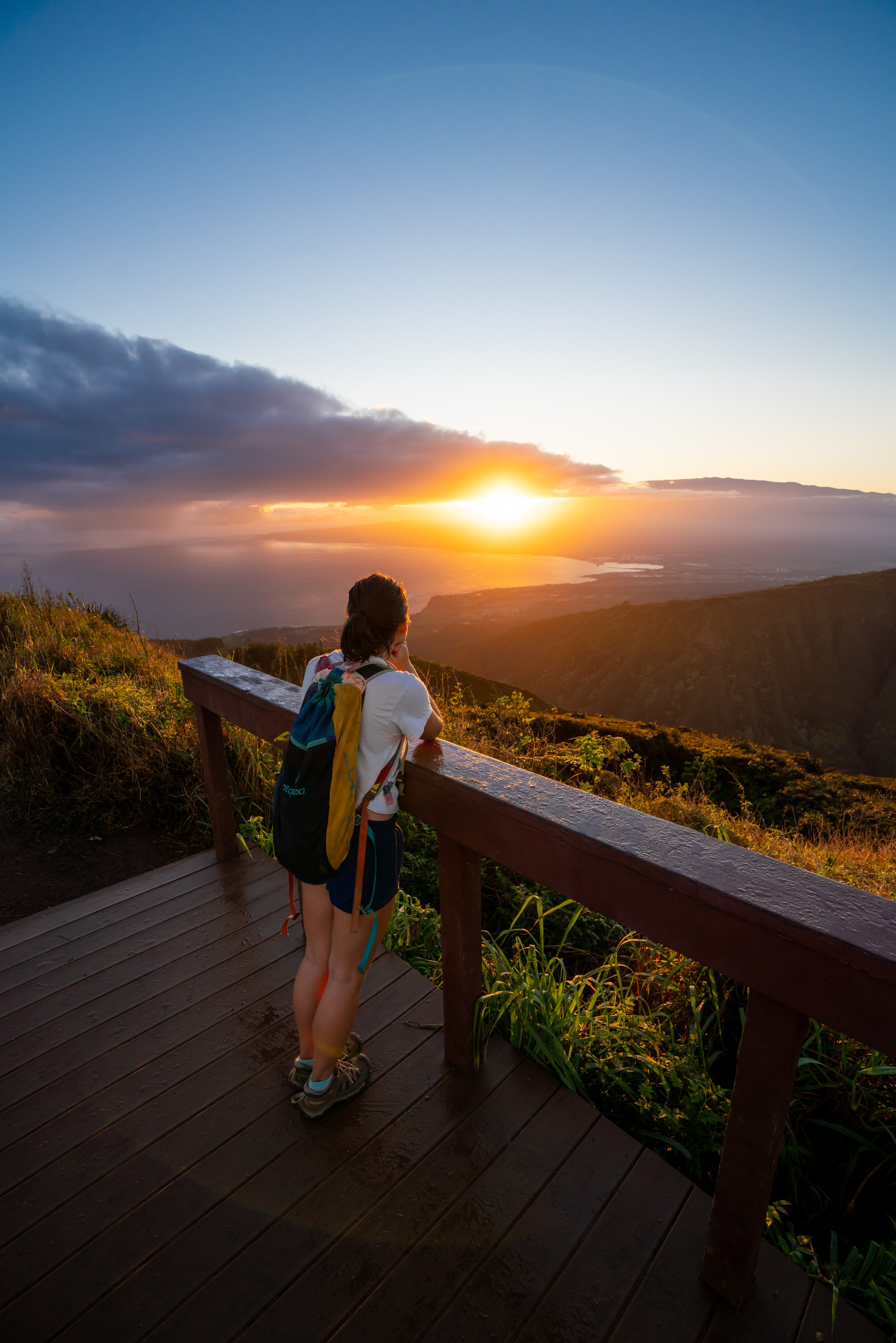
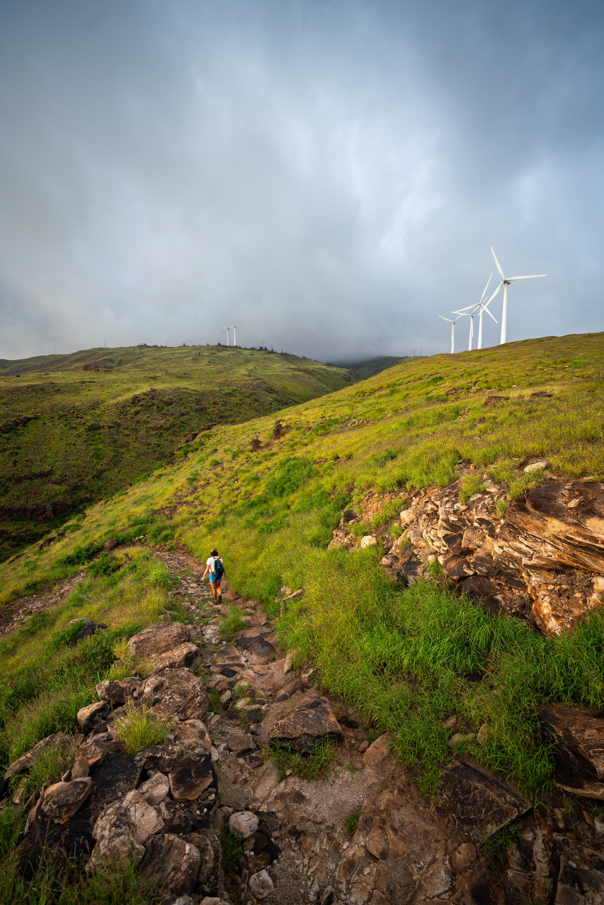
After 1.0 mile (1.6 km), the windmills on Kealaloloa Ridge become visible in the distance for the first time, which coincidentally is also the first time the East Lāhainā Pali Trail levels out since the very beginning.
From this point to the windmills on Kaheawa Pastures Access Road, the East Lāhainā Pali Trail becomes much easier, as there is only 470 ft. (143 m) left to climb over the next 1.4 miles (2.3 km), compared to the first 1.1 miles (1.8 km) that gained 905 ft. (276 m) to get to this point.
Pua Kala is encountered a lot less frequently than most other native Hawaiian plants, which is why I ask that everyone do their part to look out for it and not trample it on the Lāhainā Pali Trail.
This unnamed gulch is a nice sign that there is only 0.8 miles (1.3 km) left before the East Lāhainā Pali Trail meets McGregor Point Road.
Once again, come prepared for a largely shadeless hike, which is why bringing 2-3 L of water, as well as starting early, is highly recommended on the East Lāhainā Pali Trail.
These faint, burned trail markers are remnants from the July 2016 fire that burned much of the hillside above Māʻalaea, including the Lāhainā Pali Trail.
This second unnamed gulch is the last before the East Lāhainā Pali Trail meets McGregor Point Road.
Lower East Lāhainā Pali-McGregor Point Road Junction
With just 0.3 miles (0.5 km) to go, the East Lāhainā Pali Trail meets McGregor Point Road, where the two follow the same path for about 0.2 miles (0.3 km) until the trail splits away.
That said, go straight (left) when the trail meets the road to follow the road in and out of Malalowaiaole Gulch.
Malalowaiaole Gulch is the only named gulch on the East Lāhainā Pali Trail, which I mention because the West Lāhainā Pali Trail passes in and out of multiple named gulches, all of which make for great mental checkpoints on both the hike up and the hike down.
Upper East Lāhainā Pali-McGregor Point Road Junction
This is where the East Lāhainā Pali Trail leaves McGregor Point Road.
From here, go right and the windmills at Kaheawa Pastures Access Road will be reached just a short distance ahead!
Kaheawa Pastures Access Road (East-West Lāhainā Pali Junction)
This is where the East Lāhainā Pali Trail meets Kaheawa Pastures Access Road, signaling the end of the East Lāhainā Pali Trail and the start of the West Lāhainā Pali Trail.
On that note, Kaheawa Pastures Access Road is closed to all hikers, meaning it is illegal to hike up or down the road.
That said, most day hikers turn back here after completing the East Lāhainā Pali Trail, but if you are interested in seeing the other side, all the details can be found in my separate post linked below.
Read My Separate Post: West Lāhainā Pali Trail
Native Plants on the East Lāhainā Pali Trail
The Lāhainā Pali Trail, in general, is a low-elevation hike by Hawaiʻi standards that is dominated by non-native Fountain Grass, Kīawe, and Koa Haole.
However, the East Lāhainā Pali Trail has more native species than the West, including Maʻo, Pua Kala, ʻAʻaliʻi, ʻĀkia, ʻUhaloa, and ʻIliahi, to name a few.
If you would like to learn more about these and many other native Hawaiian plants from across the islands, I encourage you to check out my separate post linked below.
Read My Separate Post: Native Hawaiian Plant Guide