


15 Best Things to Do in Bryce Canyon National Park
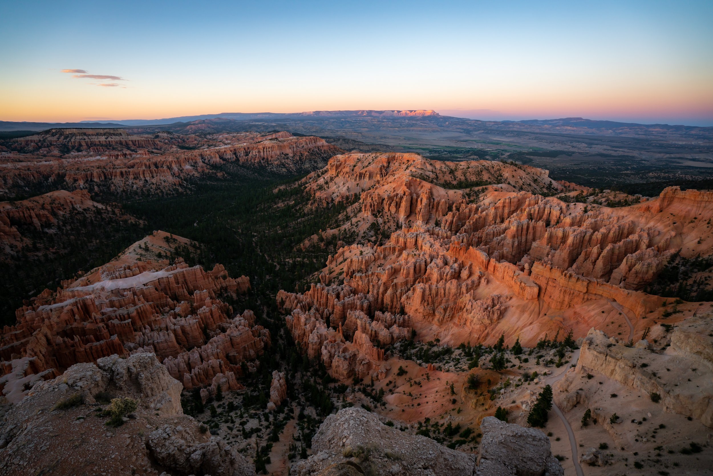
From the rugged hoodoos that look like something out of a fairytale to the snow that blankets the vibrant red rock and Ponderosa Pines throughout, Bryce Canyon National Park is, without a doubt, one of the most beautiful and unique landscapes in the world!
I say this because it really doesn’t matter what season you plan to visit, as Bryce Canyon National Park is one of the best year-round National Parks outside of Hawaiʻi!
I believe this because one of the simplest yet best things to do in the park is to drive up, park, walk a short distance, and catch sunrise at any number of beautiful overlooks scattered across the canyon rim!
That said, the hot summer heat and deep winter snow can and should influence your plans in Bryce Canyon National Park, depending on the time of year you plan to visit. For this reason, I highly recommend reading about the park in all seasons in the section below, so that you can make the most of your visit, regardless of the time of year.
What is the Best Time of Year to Visit Bryce Canyon National Park?
Located atop a high-desert mesa that climbs to an elevation above 9,100 ft. (2,774 m), Bryce Canyon National Park is known for having both hot summer temperatures that peak in the mid-80s ºF (27 ºC) and 90s ºF (32 ºC), depending on elevation, and cold, snowy winters, where snow typically sticks around until early May in some upper-elevation areas.
That said, the National Park Service maintains the majority of the roads throughout the winter season, which is why I like to think that deciding when to visit Bryce Canyon should come down to personal preference.
However, when the kids get out of school in the summer, all five National Parks across southern Utah get much busier, making the shoulder seasons my favorite time of year to visit Bryce Canyon—specifically March – mid-May in the spring and September – October in the fall.
Now, this all goes without saying that hot summer temperatures in southern Utah typically limit visitors’ willingness to hike longer trails, like the Fairyland Loop Trail, which is exactly why I like to say I would never consider hiking the full Under-the-Rim Trail later than mid-May. Elevation below the rim really does make a difference!
On the contrary, winter hiking is typically limited by the snowpack in the park, but popular trails, like the Navajo Loop Trail, often see enough traffic to make the trail manageable throughout the year.
With that in mind, be sure to come to Bryce Canyon with micro-spikes if you are visiting during the winter season (November – April), as snow and icy conditions can make the steep trails that descend from the canyon rim much more challenging and dangerous than they would otherwise be.
Hiking Checklist - Bryce Canyon
Obviously, for camping, you will need general backpacking gear. For this reason, I wrote a separate post about what backpacking gear is worth the money, from my experience, and what the best alternatives are to save you money.
Read My Separate Post: Best Ultralight Backpacking Gear
In addition, here is a complete list of must-have things that you will want for any hike in Bryce Canyon National Park.
15 Best Things to Do in Bryce Canyon National Park
The following list is written in no particular order of best or worst.
More importantly, I talk about a number of obvious and not-so-obvious tips to know at the end, many of which are things that I wish I would have known before my first visit to Bryce Canyon National Park!
On a different note, you can save time when you arrive by purchasing your National Park pass, along with your other outdoor gear, at REI before traveling to the park!
1. Navajo Loop Trail
Distance: 1.5 miles / 2.4 km
Elevation Change: ~515 ft. / 157 m
The Navajo Loop Trail is arguably the most beautiful and iconic day hike in Bryce Canyon National Park, and it’s likely the one trail you’re probably picture when thinking of the park from social media photos!
For this reason, the Navajo Loop Trail is the most popular day hike in Bryce Canyon National Park!
However, not considering the crowds, the Navajo Loop Trail is a must-see, as the stunning hike winds its way down and up two unique canyons surrounded by towering hoodoos and Ponderosa Pines—all making it one of the most beautiful and fun adventures in Bryce Canyon National Park!
Read My Separate Post: Navajo Loop Trail
2. Peek-a-Boo Loop Trail
Distance: 5.5 miles / 8.9 km
The Peek-a-Boo Loop Trail is a long, picturesque loop trail below the rim of Bryce Canyon, and it’s one that I’d go as far as to say is even more picturesque than the Navajo Loop Trail mentioned above!
That said, the Peek-a-Boo Loop is listed immediately after the Navajo Loop Trail because the two are both my top recommendations and personal favorite day hikes in Bryce Canyon National Park—not to mention, both trails can be combined into one longer adventure, which you can learn more about in my separate article linked below.
Read My Separate Post: Peek-a-Boo Loop Trail
3. Bryce Point (Sunset)
Based on the name, Sunset Point may seem like the best place in Bryce Canyon National Park to catch the sunset, but in my opinion, the more expansive, panoramic views at Bryce Point make it the much better choice!
In fact, if you talk to the right park ranger, they may even tell you that sunrise is not best at Sunrise Point and sunset is not best at Sunset Point.
In any case, Bryce Point is one of the most beautiful viewpoints in all of Bryce Canyon National Park, and it’s also the starting point for a number of trails mentioned throughout this article, such as the Bryce Canyon Rim Trail, the Peek-a-Boo Loop Trail, and the Under-the-Rim Trail!
Google Maps Directions: Bryce Point
My Print - Bryce Point (Sunset)
4. Bike the Multi-Use Path
The Multi-Use Path in Bryce Canyon National Park is a long 18-mile (29.0 km) path that extends from Red Canyon in the Dixie National Forest east of Bryce Canyon City to Inspiration Point in the heart of the Bryce Canyon Amphitheater.
That said, most visitors are typically only interested in the last 5.0 miles (8.0 km) that begin at the Bryce Canyon shuttle stop in Bryce Canyon City and ends at Inspiration Point inside the park.
If you’re coming from out of town, I encourage you to book the e-bike rentals out of Bryce Canyon City, and if you want to know more about why I love and trust Viator when booking reservations like this, read the section at the end of this list!
Google Maps Directions: Bryce Canyon Multi-Use Path
5. Rim Trail
Distance (One Way): 5.4 miles / 8.7 km
The Bryce Canyon Rim Trail is a long day hike along the rim of Bryce Canyon that connects Fairyland Point on the northern end to Bryce Point on the southern, passing all the most popular trailheads and viewpoints along the way!
This is what technically makes the Rim Trail the most trafficked trail in Bryce Canyon National Park, contrary to what I said about the Navajo Loop Trail above.
However, the Rim Trail isn’t popular for the same reasons as the Navajo Loop, as many visitors hike small parts of the Rim Trail without even knowing it, in order to connect different viewpoints or create loops with some of the trails below the rim.
In any case, hiking some or all of the Rim Trail can make for a great one-way adventure, as the free Bryce Canyon Shuttle is an easy way to get back to the trailhead where you began.
To learn more, I encourage you to read more about the full Rim Trail in my separate article linked below.
Read My Separate Post: Rim Trail
6. Under-the-Rim Trail
Distance (One Way): 22.9 miles / 36.9 km
The Under-the-Rim Trail is the backcountry in Bryce Canyon National Park, as the full trail stretches 22.9 miles (36.9 km) from Bryce Point on the northern end to Rainbow Point at the southern terminus, making it the longest one-way trail in the entire park!
That said, the Under-the-Rim Trail is often an adventure undertaken over the course of a few days, and that being the case, it is also the least-trafficked trail in Bryce Canyon National Park.
However, on one nice spring day, I decided to check this one off my bucket list by hiking the entire Under-the-Rim Trail from north to south in a single day!
For experienced hikers, doing exactly as I did is not as difficult an adventure as it may sound, and it may even be easier to hike lighter but farther, opposed to heavier over the course of a few nights.
In any case, you can learn about the entire Under-the-Rim Trail—including the locations of each campsite and water source—in my long, detailed separate article linked below.
Read My Separate Post: Under-the-Rim Trail
7. Swamp Canyon Loop Trail
Distance: 4.5 miles / 7.2 km
The Swamp Canyon Loop Trail is a lesser-known day hike that begins along the rim of Bryce Canyon and immediately descends to the canyon floor, where it connects with the Under-the-Rim Trail for roughly 1.1 miles (1.8 km) before climbing back out on a different trail to return to the same trailhead.
The reason the Swamp Canyon Loop Trail is listed immediately after the Under-the-Rim Trail is that it is the most practical and shortest option visitors have to explore a short portion of the Under-the-Rim Trail without committing to anything longer!
To learn more, I highly recommend checking out both of my separate articles, where you can see how this short section of the Under-the-Rim Trail fits into the much longer thru-hike.
Read My Separate Post: Swamp Canyon Loop Trail
8. Sunrise Point
Sunrise Point is one of many east-facing viewpoints in Bryce Canyon National Park, meaning there’s certainly no shortage of places to enjoy the sunrise from any number of beautiful drive-up locations.
That said, Sunrise Point is one of my favorites because of the way the light hits the hoodoos within Bryce Canyon Amphitheater toward Bryce Point from this unique angle!
However, as I previously mentioned, some may tell you that Sunrise Point isn’t the best place to catch the sunrise in Bryce Canyon National Park, but I hope my description and the photo below speak for themselves!
Google Maps Directions: Sunrise Point
9. Bristlecone Loop Trail
Distance: 1.0 miles / 1.6 km
The Bristlecone Loop Trail is arguably the easiest, kid-friendly day hike in all of Bryce Canyon National Park!
I say this because the vast majority of trails that begin off Bryce Canyon Road descend quickly below the canyon rim, which inevitably makes for a steep climb back up to the top on the return hike.
However, the Bristlecone Loop on the far southern end of the park traverses a mostly flat trail through the Ponderosa Pines to a beautiful viewpoint above the Riggs Spring Loop Trail.
To learn more about why I think the Bristlecone Loop makes for one of the best easy day hikes in Bryce Canyon, I encourage you to read all the details in my separate article linked below.
Read My Separate Post: Bristlecone Loop Trail
10. Stay at the Bryce Canyon Lodge
Imagine waking up in a cool, upper-elevation Ponderosa forest atop the Bryce Canyon Rim and walking out to a beautiful sunrise with a cup of coffee on the Rim Trail!
Yes, this is the Bryce Canyon Lodge, and in my opinion, it’s the best and most beautiful place to stay in Bryce Canyon National Park!
Now, this all goes without saying that the Bryce Canyon Lodge typically sells out quickly, which is why, if you know your dates, booking a reservation as far in advance as possible is the best way to guarantee your stay!

Bryce Canyon Lodge
11. Queen’s Garden Trail
Distance (Roundtrip): 1.8 miles / 2.9 km
The Queen’s Garden Trail is a stunning day hike that begins at Sunrise Point and descends below the rim of Bryce Canyon through countless beautiful hoodoos within the Bryce Canyon Amphitheater! Once at the bottom, visitors then have the option to hike back up in any number of directions, the best of which I describe in my separate article.
That said, I personally think the Queen’s Garden Trail is one of the most beautiful day hikes in Bryce Canyon National Park—one that can only be compared with the Peek-a-Boo Loop Trail and the Navajo Loop Trail!
All that aside, many visitors who hike the Queen’s Garden Trail opt to connect it with the Navajo Loop and the Rim Trail to create a one-way loop. However, I strongly recommend against connecting the Queen’s Garden Trail and Navajo Loop, for reasons that I go into in greater detail in my separate article linked below.
Read My Separate Post: Queen’s Garden Trail
12. Mossy Cave Trail
Distance: 0.9 miles / 1.4 km
The Mossy Cave Trail is a park favorite in Bryce Canyon National Park because it is the only trail in the park where visitors can go for a swim and enjoy the park’s only named waterfall on a hot summer day!
This is why, if you happen to be visiting southern Utah during the hottest summer months, the Mossy Cave Trail is one of my top recommendations—especially because it’s located outside the main and busiest area of Bryce Canyon National Park, meaning far fewer park visitors make their way over to this little-known trailhead!
Read My Separate Post: Mossy Cave Trail
13. Inspiration Point
Inspiration Point is one of the most beautiful drive-up viewpoints along the rim of the Bryce Canyon Amphitheater, and it typically makes for a less-crowded place to catch the sunrise or sunset compared to Sunrise Point and Bryce Point!
Before visiting, know that there are three different viewpoints at Inspiration Point, but the upper viewpoint, in my opinion, is the best of the three!
Google Maps Directions: Inspiration Point
14. Fairyland Loop Trail
Distance: 8.0 miles / 12.9 km
The Fairyland Loop Trail is a beautiful but longer day hike on the north side of Bryce Canyon that descends below the rim and passes a number of unique formations within the hoodoos before looping back up to the Bryce Canyon Rim Trail to return to the beginning.
That said, the Fairyland Loop is one of my top recommendations if you want to see the best of what the park has to offer but don’t have time to commit to anything else!
I say this because the Fairyland Loop Trail may be longer, but because it’s longer, far fewer park visitors venture out on the loop compared to the adventures within the Bryce Canyon Amphitheater, making it a great place to not only see the best of the park but also escape the crowds at the same time!
Read My Separate Post: Fairyland Loop Trail
15. Bryce Canyon Private Tour Guide
Among a vast network of interconnected trails and viewpoints, Bryce Canyon National Park can seem overwhelming if you’re visiting the park for the first time!
However, there are a number of guided tour options to consider if you’d prefer to learn about the park from one of a few local tour guides.
Why am I Recommending these Viator Tours?
One of my favorite things about booking through Viator is the reserve-now-and-pay-later option. As long as you’re booking more than three days in advance, you have the option to book ahead and cancel in the future if you change your mind.
Additionally, I’ve included these tours because doing this, like the biking the Multi-Use Path, might impractical if you’re not from the area. Therefore, the tour options I’ve listed are a safe and amazing way to experience Bryce Canyon and the greater area, and they offer the opportunity to discover nearby adventures that you may not have heard of otherwise!
20 Best Things to Do Near Bryce Canyon National Park
Based on where Bryce Canyon is located in southwestern Utah, recommending the best things to do in the area entirely depends on what direction you’re driving to or from.
Therefore, the list below is fairly broad, but I wanted to include a list of adventures within a few hours in any direction of Bryce Canyon National Park, which is why these recommendations come from both Utah and Arizona!
1. Coyote Gulch (Jacob Hamblin Arch)
Escalante, Utah, and everything that the Grand Staircase–Escalante National Monument has to offer is truly the backdoor of Bryce Canyon National Park!
That said, Coyote Gulch is arguably the best of the best within the Grand Staircase, though some would say I’m splitting hairs considering how many world-class adventures are located within the National Monument.
As for the hike to Coyote Gulch, my separate article is quite old, but it talks about the quickest and most direct way to access the most beautiful sections within Coyote Gulch, at just 2.4 miles (3.9 km) each way via the 40-Mile Water Tanks.
For this reason, hiking to the gulch can be either a day hike or an easy overnight adventure, as there is really so much to explore beyond the renowned Jacob Hamblin Arch and the Amphitheater shown in the photo below!
Read My Separate Post: Coyote Gulch via Water Tanks
2. Ice Cream at Old Bryce Town
On a hot summer day, there’s nothing quite like stopping in for ice cream at Old Bryce Town in Bryce Canyon City!
Personally, I love visiting to get out of the sun for a little while after hiking one of the many beautiful trails within the park, as it not only makes for a great place to get ice cream but also a great place to walk around and explore the different shops in the area.
Yelp: Old Bryce Town
3. Pink Ledges Trail
Distance: 2.2 miles / 3.5 km
The Pink Ledges–Birdseye–Photo Loop Trail are three separate short trails just outside of Bryce Canyon National Park that are commonly combined to make one beautiful day hike through a lesser-known area of hoodoos within the Dixie National Forest!
That said, I know I speak highly of all the adventures within the National Monument just outside of Escalante to the east, but in reality, they are not nearly as accessible as those within Red Canyon to the west.
This is why, if accessibility and the car you’re driving are less likely to do well on the remote Hole-in-the-Rock Road, this short 2.2-mile (3.5 km) loop trail can make for a great, short, easy, and less-involved adventure near Bryce Canyon for people of all ages!
Read My Separate Post: Red Canyon Loop Trail
4. Showdowns Restaurant
If you read my tips below, you’ll understand why I don’t recommend many of the dining options in Bryce Canyon City.
However, just down the road in Tropic, there are a number of great options to choose from, and none are as good as Showdowns on the south side of town!
With live music, great food, and great drinks, Showdowns Restaurant is my top dining recommendation near Bryce Canyon National Park!
Yelp: Showdowns Restaurant
5. Moqui Sand Caves
Distance: 1.2 miles / 1.9 km
The Moqui Sand Caves Trail is an easy, roadside day hike just outside of Kanab, about a 30-minute drive from the East Entrance on Zion–Mount Carmel Highway.
That said, I personally like the Moqui Sand Caves as a great short adventure to escape the summer heat or when looking for something a little less crowded than all the adventures up in the park.
Either way, the Moqui Sand Caves makes for a fun, quick, easy to get outside, and the trail can easily be combined with a trip to The Wave in the North Coyote Buttes area of the Paria Canyon–Vermilion Cliffs Wilderness just outside of Kanab.
Read My Separate Post: Moqui Sand Caves Trail
6. Shop Local National Park Gear
About as local as it can get, a few of my good friends out of St. George, Utah, design their own National Park gear inspired by parks around the country!
In fact, my camera strap, made by my friends at WildTree, has been the longest-standing camera strap I’ve owned.
I mention all this because, if you want to take home something to remember your trip to Bryce Canyon, I encourage you to check them out over any of the overpriced souvenirs in Bryce Canyon City!
Shop: WildTree
7. Antelope Canyon Tour
Antelope Canyon is a renowned slot canyon in the small town of Page in northern Arizona that is beloved by travelers from across the world!
That said, Antelope Canyon, and everything that Page, Arizona has to offer, is only a 2-hour, 45-minute drive away from Bryce Canyon City!
If it’s your first time visiting, you may be asking one of the biggest questions regarding both Upper and Lower Antelope Canyon, which is: What tour is better?
Answering this question is exactly why I wrote a separate article, where I share my honest side-by-side comparison of both canyons, as I have been fortunate to visit Page and Antelope Canyon many times!
Read My Separate Post: Upper vs. Lower Antelope Canyon
Lower Antelope Canyon

My Print - Upper Antelope Canyon
Upper Antelope Canyon
8. Horseshoe Bend
Distance (Roundtrip): 1.5 miles / 2.4 km
It’s certainly not fair to talk about Page without mentioning the iconic Horseshoe Bend and the short trail just up the road!
Horseshoe Bend is one of the best things to do in Page, Arizona, and it’s truly a must-see if you’re already making the trip to the area to see Antelope Canyon.
That said, I personally love hiking the Horseshoe Bend Trail for sunset, as the west-facing viewpoint above the Colorado River is, without a doubt, one of the best year-round sunset hikes in northern Arizona!
Read My Separate Post: Horseshoe Bend Trail
9. Big Lake Sand Cave
Distance: 0.2 miles / 0.3 km
Going along with the previous two, the Big Lake Sand Cave is another hidden gem in Page, Arizona, as it’s located in a very unsuspecting location right on the edge of town.
To learn more, including my thoughts on the best time of day to visit the Shell Gas Station Cave, I recommend checking out my separate article linked below.
Read My Separate Post: Big Lake Sand Cave Trail (Shell Gas Station)
10. Rustler’s Restaurant
With very few dining options for both lunch and dinner, there are even fewer when it comes to breakfast near Bryce Canyon National Park.
However, Rustler’s Restaurant in Tropic is my number one pick if you’re looking for a nice small-town diner to sit down and enjoy breakfast near the park!
Yelp: Rustler’s Restaurant
11. Peek-a-Boo & Spooky Slot Canyons
Distance: 6.0 miles / 9.7 km
The Grand Staircase-Escalante National Monument is, without a doubt, one of the most beautiful places to explore in southern Utah. However, don’t underestimate how much of an adventure Hole-in-the-Rock Road within the monument is on its own!
What I mean when I say this is that most adventures out of Escalante, like Peek-a-Boo and Spooky Slot Canyons, begin down the long, remote Hole-in-the-Rock Road.
This drive is incredibly tedious and slow, both in a two-wheel and a four-wheel-drive vehicle, which may be necessary depending on the time of year, such as during the summer monsoonal season, when rain can flood and wash out sections of the road.
For this reason, it’s important to come prepared for the current conditions, which is why I recommend calling the Escalante Interagency Visitor Center prior to heading out.
In any case, both Peek-a-Boo and Spooky Gulch are some of the best day hikes outside of Escalante, but if you’d like more of a guarantee on this fun but remote adventure, I recommend booking with one of the local guides out of Kanab. This is the best and safest way to get out in the National Monument without having to worry about your personal vehicle.
AllTrails: Peek-a-Boo & Spooky Slot Canyons
12. Arriba Mexican Grill
Aside from Showdowns, located in Tropic east of the park, Arriba Mexican Grill is my top dining recommendation for a place closer to Bryce Canyon City!
I say this because their large menu, great drinks, and big dinner plates are sure to help everyone in your group find something that they’ll enjoy!
Yelp: Arriba Mexican Grill
13. Grand Canyon National Park
As if the Grand Canyon needs its own introduction, know that Grand Canyon Village on the South Rim is only a four-hour, 50 minute drive from Bryce Canyon City.
That said, I’ve written an entirely separate article about Grand Canyon National Park, which includes my favorite sunrise and sunset spots, day hikes, backcountry adventures below the rim, and great insider advice regarding what to expect when visiting both sides of the canyon!
Read My Separate Post: Grand Canyon National Park
14. Havasupai Trail
Distance (One Way to The Confluence): 16.7 miles / 26.9 km
Elevation Change: ~3,300 ft. (1,006 m)
The Havasupai Trail—much like the Rim-to-Rim Trail in Grand Canyon National Park—is, without a doubt, one of the best backpacking adventures in the Southwest U.S.!
However, Havasupai is truly one of the most exclusive backcountry adventures there is, because of how challenging it can be to secure one of these elusive permits.
This is exactly why I wrote such a long and detailed post about the entire Havasupai Trail, the permits, and all the separate day hikes—including The Confluence—which is why I highly recommend checking out my separate article if you’re planning to visit or want to know how to visit Havasupai in the future!
Read My Separate Post: Havasupai Trail
15. Coral Pink Sand Dunes State Park
Just to the south of Zion, near Kanab and the Moqui Sand Caves, is a little lesser-known state park known as the Coral Pink Sand Dunes.
In short, the Coral Pink Sand Dunes are a stunningly beautiful 5.3-square-mile (13.6-square-km) dune field that makes for a fun place to run around and explore—especially at sunset, when the golden light brings out the best of the colors on the dunes and the surrounding landscape!
Google Maps Directions: Coral Pink Sand Dunes State Park
16. Capitol Reef National Park
Capitol Reef National Park is often the most overlooked of the five National Parks across southern Utah, as visitors typically only spend a few hours exploring all there is to see and do!
That said, I have visited Capitol Reef a number of times, with my favorite recommendations being the Cassidy Arch Trail, the Grand Wash Trail, and, of course, the homemade pie in the Fruita Historic District!
However, I do not feel I have the best photos and experience to write a similar article as I have with countless other National Parks across the country, though I will soon enough!
In any case, the main thing that has stood out to me over numerous visits is just quiet Capitol Reef is compared to the other National Parks across southern Utah, and that’s not because it isn’t as beautiful—it’s because of accessibility.
Much of Capitol Reef National Park is located in very remote areas, stretching some 100 miles (161 km) from north to south across the desert. This is why few ever make it to some of the best, hard-to-reach areas, and it’s why exploring all the hidden gems within the park takes a lifetime to truly appreciate!
Google Maps Directions: Capitol Reef National Park
17. Kanarra Falls
Distance: 3.8 miles / 6.1 km
The Kanarra Falls Trail is a stunning out-and-back day hike near the Kolob Canyons District of Zion National Park that has become a favorite among visitors, as the short 1.9-mile (3.1 km) trail features numerous waterfalls, narrows that closely resemble The Narrows in Zion National Park, and a number of fun scrambling sections in the uppermost portions of Kanarra Creek!
Before visiting, I highly recommend reading my separate post, as there is quite a bit to know about the Kanarra Falls Trail—particularly when it comes to the permit system and the somewhat rugged trail itself, which you can learn all about in my article linked below.
Read My Separate Post: Kanarra Falls Trail
18. Arches & Canyonlands National Park
In this part of the country, everything can feel spaced out from one another, but Bryce Canyon National Park, and the parks in Moab are two places that make for a great roadtrip when put together!
This is why, if you enjoyed reading everything I’ve written about Bryce Canyon, I recommend checking out my separate articles about both Arches and Canyonlands National Park, where I share the same inside information about everything there is to see and do on all sides of each park.
Read My Separate Posts: Arches National Park / Canyonlands National Park

My Print - Canyonlands National Park
19. Zion National Park
Going along with the last recommendation, it’s impossible to talk about Bryce Canyon National Park without mentioning Zion, as both are commonly visited on the same trip when driving across Northern Arizona and southern Utah.
On that note, I have been visiting and revisiting Zion for many years, just as I have with Bryce Canyon, which is why I believe the list I’ve created about the park truly offers the best tips and recommendations you will find—especially when it comes to hiking the Angels Landing Trail.
Read My Separate Post: Zion National Park
20. Cathedral Wash Trail
Distance: 3.4 miles / 5.5 km
The Cathedral Wash Trail in the Glen Canyon National Recreation Area is one of my top day hiking recommendations outside of Page and Grand Canyon National Park.
I say this because for those interested in hiking to the Colorado River, the Cathedral Wash Trail is much quicker and easier than either the Bright Angel Trail, the South Kaibab Trail, or the North Kaibab Trail—granted that you are comfortable with some Class 3 scrambling, which you can see and learn about in more detail in my separate post linked below.
Read My Separate Post: Cathedral Wash Trail
5 Tips for Visiting Bryce Canyon National Park
1. The best dining options are all outside of Bryce Canyon City.
If you spend more than a day in the Bryce Canyon area, it quickly becomes apparent how few places there are to get good food. I mean, there are places to get food, but I mean good food!
In fact, the only restaurant in Bryce Canyon City that is worth stopping in is Arriba Mexican Grill, mentioned above. Outside of this, I highly recommend going down to Tropic for a much better selection than the few options near the park.
2. Bring sunglasses and wear a hooded sun shirt.
Ponderosa Pine forests do what they can in terms of providing shade, but it’s no secret that the sun exposure can be dangerous in southern Utah—especially during the hot summer months!
For this reason, I highly recommend hiking with a good pair of sunglasses and a hooded sun shirt because, over the course of a long visit, sunscreen just isn’t enough—which is even more true if you plan on visiting more than one of Utah’s beautiful National Parks on the same trip.
3. Spend more than one day in Bryce Canyon National Park.
Compared to Zion and the parks in Moab, Bryce Canyon and Capitol Reef are typically given the least amount of time.
Often, visitors will only spend a day or even half a day in Bryce Canyon when visiting all five of Utah’s parks, but as you can see from the list above, one day is simply not enough time!
This is why I personally recommend at least two and a half days to try and enjoy the best of all there is to see and do in and near Bryce Canyon National Park.
4. Hike with a good water bladder.
One of the most difficult things regarding the trails in Bryce Canyon is the elevation change and hot summer heat.
Typically speaking, hikes that begin from the Bryce Canyon Rim always start off light and fast as you descend down into the canyon, but this inevitably comes with a steep and typically exposed hike back up to the top.
All I can say is that a single-use water bottle simply isn’t sufficient for the steep trails in Bryce Canyon National Park—especially during the summer—as I continually stress!
5. Summer monsoonal thunderstorms are exceptionally dangerous in Bryce Canyon.
Upper-elevation areas like Bryce Canyon National Park, and countless others across the Mountain West, can be particularly dangerous in the summer when thunderstorms are more common during the monsoon season.
This is why it’s always important to remain indoors or in your car during a storm, and if you ever get caught in a storm unsuspectingly, follow the steps linked below to reduce the risk of getting struck.
National Park Service: Lightning Safety Tips