Hiking the Panoramic Point Trail in Kings Canyon National Park
Distance: 0.5 miles / 0.8 km
The Panoramic Point Trail in Kings Canyon National Park is a very short and easy loop trail that I believe is one of the best, easiest, and often overlooked adventures in the Grant Grove District, especially when compared to other nearby adventures, like the busy General Grant Tree Trail!
I say this because the views from Panoramic Point lookout toward Kings Canyon, and far beyond to some of the highest summits in the lower 48 states, all making the Panoramic Point Loop one of the best day hikes to try to get a sense of just how deep and expansive Kings Canyon National Park truly is!
That said, I highly recommend hiking the Panoramic Point Trail if you’re visiting Kings Canyon National Park but don’t have time to drive Highway 180 to the Cedar Grove District, as it is the best place to see much of the park from above without committing to the long out-and-back drive to get to the Kings River at the bottom of the canyon.
Panoramic Point Trailhead Parking
The Panoramic Point Trailhead is located at the very top of Panoramic Point Road, about 2.3 miles (3.7 km) up the hill from Grant Grove Village.
That said, the road past the John Muir Lodge can be a bit windy and narrow, which is why it’s important to take your time, as there are a number of blind turns to look out for.
Google Maps Directions: Panoramic Point Trailhead
Hiking Checklist - Sequoia-Kings Canyon
Here is a complete list of must-have things that you will want for any hike in Sequoia and Kings Canyon National Park.
That said, bear spray is purposefully excluded from this list because, while the Sierra Nevadas are home to a large Black Bear population, bear spray is not allowed in either Sequoia or Kings Canyon National Park.
Hiking the Panoramic Point Trail
The Panoramic Point Trail follows a paved path from the trailhead to both overlooks, making it one of the most accessible day hikes in Kings Canyon National Park.
Panoramic Point Loop Trail
After 0.1 miles (0.2 km), the Panoramic Point Trail splits into a loop that leads to both overlooks along the upper trail.
Personally, I chose to go right, which is also the most direct route to reach the beginning of the Park Ridge Trail, starting at the Park Ridge Overlook.
Panoramic Point-Park Ridge Junction
Just before the Panoramic Point Loop reaches the top, the trail splits once again into the route that leads to the Park Ridge Overlook and the beginning ridge trail, as well as the return loop that leads down to Panoramic Point.
Here, I chose to go right toward the Park Ridge Overlook.
Park Ridge Overlook
The Park Ridge Overlook is the uppermost viewpoint on the Panoramic Point Trail, which is also where it leaves behind the paved path and begins the 2.4-mile (3.9 km) hike up Park Ridge to the Fire Lookout at the summit.
Read My Separate Post: Park Ridge Trail
Panoramic Point-Park Ridge Junction
After spending some time at the Park Ridge Overlook, I continued back down to the main Panoramic Point Overlook, which is the best place to learn more about what you’re looking at in the distance.
At this split, go right to reach Panoramic Point shortly ahead.
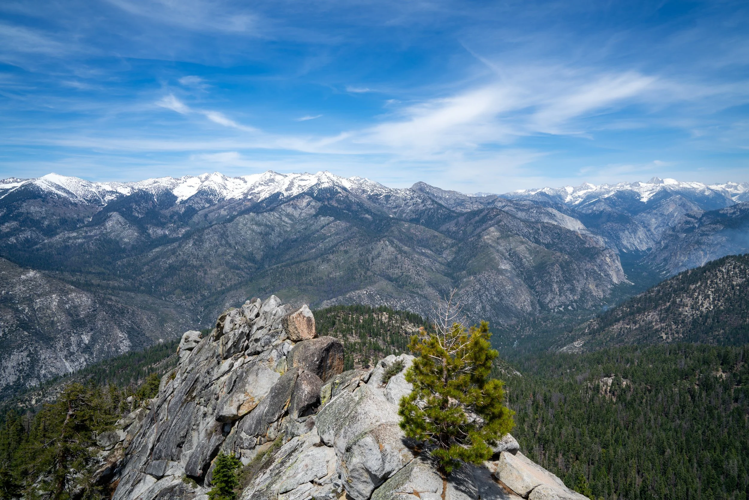
Panoramic Point
The Panoramic Point Overlook is the best place in Kings Canyon National Park to enjoy an upper vantage point of Kings Canyon from above.
In addition, notable summits, like the glaciated North Palisade Peak, can be seen in the distance, which is one of several California summits that stands at over 14,000 ft (4,267 m), like the much more renowned Mt. Whitney to the south.
Once back on the trail, the Panoramic Point Loop simply makes its way back down to the beginning.
Panoramic Point Loop Junction
This is where the Panoramic Point Loop Trail returns to the start, with just 0.1 miles (0.2 km) remaining to return the trailhead.
Sequoia National Park


Kings Canyon National Park