Hiking the Columbine Lake Trail in Silverton, Colorado
Distance: 6.8 miles / 10.9 km
Elevation Gain: 2,360 ft. / 719 m
The Columbine Lake Trail in the San Juan Mountains of southwestern Colorado is one of the most beautiful day hikes off the scenic Million Dollar Highway!
I say this because, as you ascend the steep trail, you’ll be rewarded with panoramic views of the surrounding mountains, filled with vibrant wildflowers in the summer, rolling green hills, towering peaks, and an array of different wildlife.
For these reasons, the Columbine Lake Trail is truly a must-see if you’re visiting nearby areas such as Black Canyon of the Gunnison, or even places as far away as Arches and Canyonlands National Park in Moab.
Ice & Island Lake vs. Columbine Lake
I have been fortunate enough to hike both the Ice and Island Lake Trail, as well as the Columbine Lake Trail, numerous times to give you my honest thoughts about both. With that said, I personally enjoy the Columbine Lake Trail more than the Ice Lake Trail.
I say this because I feel that the hike, as well as Columbine Lake itself, is more beautiful than both Ice and Island Lakes. On top of this, the Columbine Lake Trail is nearly never as busy as the Ice Lake Trail, due in large part to the impacts of social media.
However, this goes without saying that the Columbine Lake Trail climbs about 300 ft. (91.4 m) higher than the Ice Lake Trail, meaning that some visitors may have difficulty reaching the 12,700-ft. (3,871 m) lake at the top of the hike.
All being said, this is just one person’s opinion, and recommending one trail over another is truly splitting hairs, as both the Ice Lake and Columbine Lake Trails are stunning, world-class adventures!
Read My Separate Post: Ice & Island Lake Trail

My Print - Columbine Lake
Columbine Lake Trailhead Parking
Parking for Columbine Lake is located just off the Million Dollar Highway, about 18 miles (29.0 km) south of Ouray and 5.0 miles (8.0 km) north of Silverton, CO.
That being said, low-clearance vehicles typically do not park at the true Columbine Lake Trailhead because the final stretch up Forest Road 820 is generally only practical for high-clearance, 4WD vehicles.
Instead, parking at the Lower Columbine Lake Trailhead, shown below, is more common and only adds about 0.6 miles (1.0 km) each way along Forest Road 820 to reach the Columbine Lake Trailhead.
Google Maps Directions: Columbine Lake Trailhead
Hiking Checklist - San Juan Mountains
Obviously, for camping, you will need general backpacking gear. For this reason, I wrote a separate post about what backpacking gear is worth the money, from my experience, and what the best alternatives are to save you money.
Read My Separate Post: Best Ultralight Backpacking Gear
In addition, here is a complete list of must-have things that you will want for any hike in the San Juan Mountains.
Hiking the Columbine Lake Trail
From the trailhead off Forest Road 820, the Columbine Lake Trail climbs up 13 switchbacks—depending on how you count—for about 1.3 miles (2.1 km) until the trail reaches tree line.
These switchbacks are fairly steep, and it may be difficult for some people if you’re not ready for the elevation, which begins at about 10,340 ft. (3,152 m) at the trailhead.
For these steeper sections in the beginning, some hikers may prefer trekking poles, which can be especially useful on the hike back down.
On account of the Columbine Lake Trail being so high and steep, I highly recommend hiking with at least three liters of water—especially during the hotter summer months.
After 1.3 miles (2.1 km), tree line ends about 11,600 ft. (3,536 m), with yet a few miles to go before reaching Columbine Lake.
For this reason, I recommend hiking in a quality sun shirt because even with sunscreen, it’s much easier to burn at these higher elevations in Colorado.
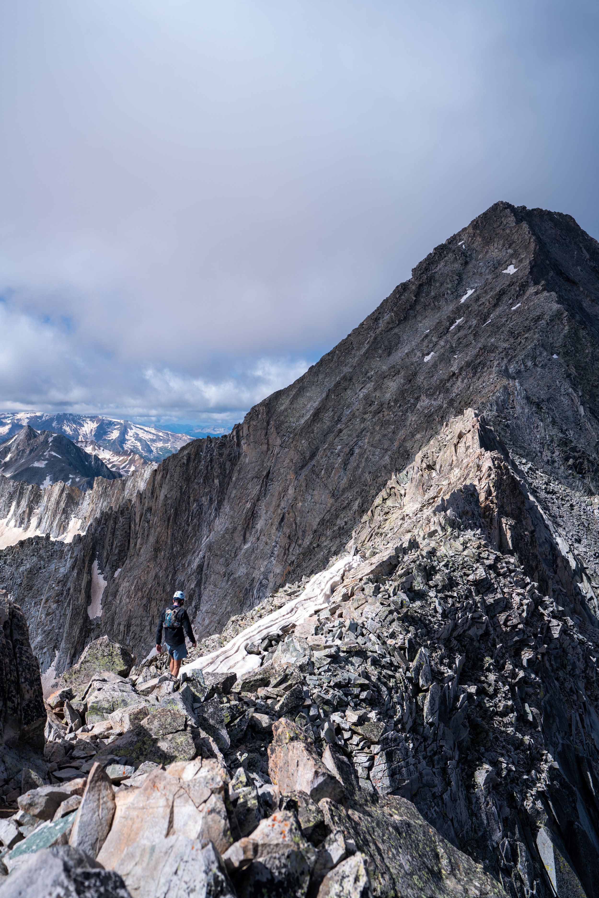
Once above tree line, the Columbine Lake Trail continues to climb until you make it through the unnamed pass, which is the low point in the photo below.
I personally enjoy how the Columbine Lake Trail is much more visual than the Ice Lake Trail, meaning that it’s easier throughout the hike to see where the trail is going, outside of the initial 1.3 miles (2.1 km) below tree line.
Columbine Lake-Ophir Pass Road Connector Junction
The one and only time the Columbine Lake Trail splits with another trail is here, with the Ophir Pass Road Connector, which leads to the small town of Ophir and other destinations, such as the Ice Lake Trail.
That being said, go straight (right) here to continue up to Columbine Lake.
After the Ophir Pass Road junction, the Columbine Lake Trail continues toward the unnamed pass, which becomes much easier to see as it traverses beneath the peak in the photo below.
This short section is the most exposed portion of the entire Columbine Lake Trail, and mico-spikes may be necessary during the early and late summer season if there is snow and ice along the trail.
Once at the unnamed pass, the Columbine Lake Trail levels out significantly compared to the beginning, and there is only about 200 ft. (61 m) of additional elevation to climb to reach the lake, meaning the most strenuous part of the hike is over!
In my opinion, the last 1.2 miles (1.9 km) leading up to Columbine Lake is the most beautiful section.
At this split, you can take whichever trail looks easiest to reach Columbine Lake, as they both meet shortly ahead.
This is where the two trails come together again along the Columbine Lake outlet.
Columbine Lake
Finally, after roughly 3.4 miles (5.5 km) of hiking and 2,360 ft. (719 m) of elevation gain, the Columbine Lake Trail ends at the stunning turquoise-blue waters of Columbine Lake at around 12,700 ft (3,871 m).
On a different note, I have seen one group in all my times hiking up to Columbine Lake with fishing gear, but I couldn’t speak to how good the fishing is here or on the nearby Ice Lake Trail.
That said, some reports mention Columbine Lake holding rainbow, cutthroat, and brook trout, with brook trout being the best to catch, so if you have the gear and a valid fishing license, I think it’s easy to see why spending a few hours fishing the beautiful shores of Columbine Lake is one of the best things to do on the Million Dollar Highway!