Climbing Capitol Peak via Northeast Ridge (Knife Edge): Colorado’s Hardest 14er
Distance: 17.7 miles / 28.5 km
Capitol Peak in the Elk Mountain Range of central Colorado is often regarded as the state’s hardest 14er, inevitably making Capitol Peak one of the most sought-after summits of the 58 highest peaks in the Centennial State.
Considering the challenges involved, coming prepared and/ or knowing if you’re ready for such a high-risk summit is one of the most difficult things to describe when writing an article like this, but, I will do my best.
How Hard is Capitol Peak?
First, and perhaps most importantly, there is no way around the high Class 4 exposure on the upper mountain, meaning you need to be the type of person who can always remain calm, even in dangerous situations.
To answer the question “How hard is Capitol Peak?”, I would say that the 14ers.com article does an excellent job at showing the route, talking about how hard and dangerous the climb is, and making the summit sound a little intimidating, which I believe is appropriate. I don’t think that climbing Capitol Peak is for everyone, and this was even true among our group of four.
Capitol Peak Trailhead Parking
Parking for the Capitol Creek Trailhead is located at the very end of Capitol Creek Road in Snowmass, Colorado.
Know that the last 1.9 miles (3.1 km) before the trailhead can be very rough or even impassable for low-clearance vehicles, which may require hiking further if you don’t feel comfortable driving all the way.
If this is the case, use the overflow parking lot.
Google Maps Directions: Capitol Creek Trailhead
Climbing Checklist - Elk Mountains
Obviously, for camping, you will need general backpacking gear. For this reason, I wrote a separate post about what backpacking gear is worth the money, from my experience, and what the best alternatives are to save you money.
Read My Separate Post: Best Ultralight Backpacking Gear
In addition, here is a complete list of must-have items that you will want for any hike in the Elk Mountains, and know that the National Forest Service requires the use of bear canisters for all camping at Capitol Lake.
Hiking the Capitol Peak Trail
Since our hike began in the middle of the night, most of the photos are from our hike out.
On a different note, the distance posted above is by hiking both the Capitol Creek Trail on the way in, and the Capitol Ditch Trail on the way out.
Initially, I would have liked to plan our climb over the course of three days, with two nights at Capitol Lake. However, the summer monsoonal weather never gave us that luxury.
For this reason, we started our trek to Capitol Lake at 1 a.m.
Capitol Creek Trail vs. Capitol Ditch Trail
Personally, I didn’t find one to be more or less difficult than the other, but you essentially have to decide if you would rather cross Capitol Creek on a bridge, utilizing the Creek Trail, or by taking off your shoes on the Ditch Trail.
Additionally, the Capitol Creek Trail descends about 400 ft. (122 m) of elevation, which is why some might prefer the Ditch Trail in order to maintain elevation.
Beginning from the Capitol Creek Trailhead, we started our hike on the Capitol Creek Trail, so that we wouldn’t have to take off our shoes to cross Capitol Creek in the middle of the night.
Capitol Creek
In our experience, finding a way to cross Capitol Creek without taking our shoes off on the hike out wasn’t possible following an average snow year in early July.
Capitol Creek-Capitol Ditch Junction
Immediately after Capitol Creek, both the Capitol Creek and Capitol Ditch Trail become one trail for the remainder of the hike.
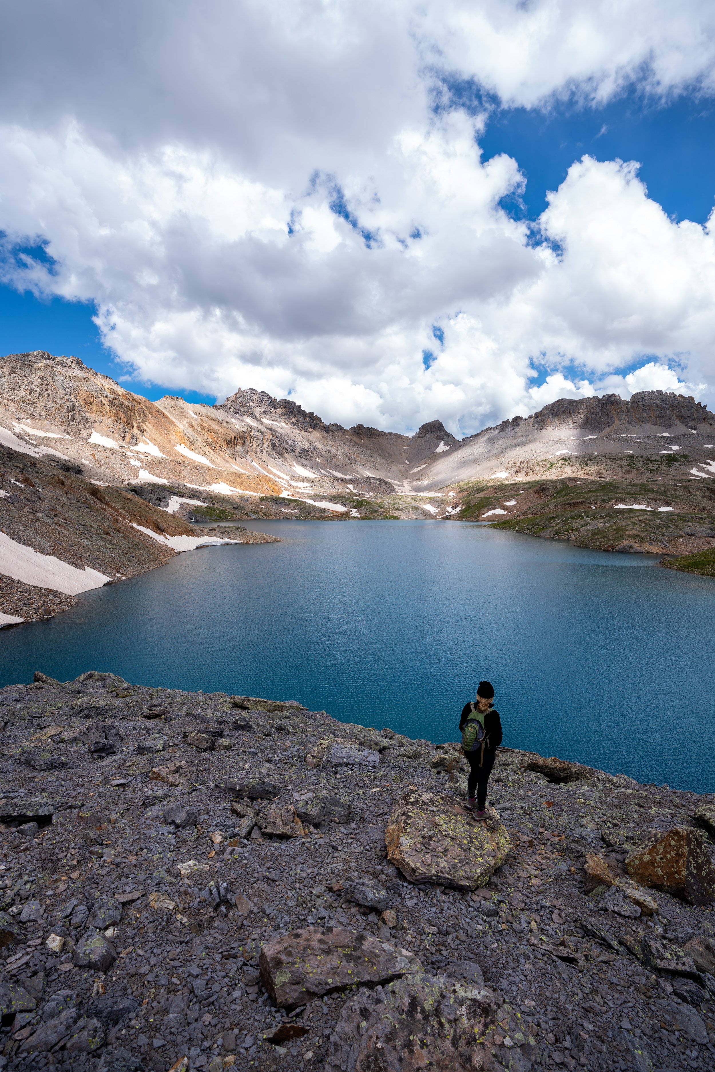
Capitol Lake
Again, be aware that the National Forest Service requires bear canisters for camping at Capitol Lake.
In any case, we arrived at Capitol Lake a little after 4:00 a.m., hiking a fairly moderate pace.
Daly Saddle
Then, by the time we climbed above Capitol Lake to the Daly Saddle, we caught the sunrise coming through the West Snowmass Creek Basin, which definitely started to make things warmer above 12,500 ft. (3,810 m).
If an ice axe and crampons are necessary, this is where you’ll likely want to start using them, if not at Capitol Lake.
From the Daly Saddle, you have two options for how to proceed.
First, you can either follow the traditional route through the upper West Snowmass Basin, or you can traverse the cliffs to K2, so that you can maintain your elevation.
We opted for the traverse, which may or may not be a better option for some groups, given that there are a few class 4 sections, depending on which route you take across.
K2 Traverse vs. The Traditional Route
In my opinion, I think it’s a toss-up regarding the benefits of each route. If you’re in good shape, I think that the longer route through the basin could possibly be quicker than the traverse, where you constantly need to be thinking about every move.
That being said, I would have preferred hiking through the basin on the way back because of how tired I was from a night of no sleep and the early start, being that I didn’t feel as comfortable making some of the same moves as I had earlier in the day because of this. However, our group opted for the traverse both ways.
K2
On a clear day, you should have views of the summit ridge from K2, but, when we arrived, there was a group on K2 that never proceeded any further because they were concerned about a low-hanging cloud over the summit that was making the granite wet. Considering this, they chose to turn back, but if they had waited just a little longer, they would have seen the summit clear, making it a perfect bluebird day.
In any case, this set the mood that proceeding may not be a good idea. However, I said to my friend John that I want to go until the conditions tell us otherwise, as I am very used to high-exposure hiking on wet terrain in Hawaiʻi.
Warning
There’s no easy way to say it, but some hikers are not capable of climbing past K2.
To this point, if you or anyone in your group experienced any difficulty with the route up to this point, turn back, as the climbing and the route-finding only get harder and more dangerous than anything prior to K2 the closer you get to the summit.
In addition, everything starting with the K2 descent and following is a no-fall zone, meaning there is no coming back from a fall on either the Capitol Lake or Pierre Lakes side of the ridge.
K2 Descent
From K2, you need to contour the ridge to the right when you’re facing Capitol Peak, as proceeding forward from K2 essentially cliffs out.
Knife Edge
You may be thinking that the Knife Edge on Capitol Peak is a very long section of the ridge to the summit, but in reality, the Knife Edge’s is only about 20 ft. (6.1 m) or less. Furthermore, most of the summit ridge to base of the final ascent can either be walked directly on or on either side of the ridge, as there are many places to figure out three points of contact across the entire ridgeline.
On the Knife Edge itself, I opted for the much less popular choice of actually sitting and scooting across the ridge because I’ve heard horror stories of a piece of granite breaking off that a climber was using for their handhold.
That being said, it was quite uncomfortable to sit on it, but in reality, the Knife Edge is such a short section to get through, making it pretty quick in all.
For the last 0.25 miles (0.4 km), the final ascent to the summit is climbed to the left (south) of the actual ridge.
You may or may not see small rock cairns, depending if you follow the best route, but there are a few different variations of the same route to the summit. However, many groups have reported getting 'lost' in this section, which is why I recommend studying the route well if this will be your first attempt on Capitol Peak.
Additionally, it’s important to space out from others in your group on this final ascent, as rockfall poses the biggest threat of the entire climb along this contour.
Capitol Peak
According to the USGS, the summit of Capitol Peak is 14,130 ft. (4307 m), and when we summited, our group had the top entirely to ourselves!
After only a few minutes, the clouds cleared giving us amazing 360º views from the top!
Climbing Down Capitol Peak
Since we opted for the traverse on the way back, I never felt like I had a break until we made it back to the Daly Saddle because it is only at the Daly Saddle that the real trail begins for the rest of the hike back out.
How Hard is Climbing Capitol Peak?
Talking about difficulty regarding any hike or climb is challenging to relate across all people.
By this, I mean that some would say that the switchbacks up to the Daly Saddle on a different trail would make the hike hard, but here’s how I can try to break it down.
The exposure on the upper mountain is very real, and a fall would most likely be fatal. That being said, not every high-exposure section is a 2,000 ft. (610 m) drop. Some drops are only 40 ft. (12 m), but even then, the result of a fall would be no different.
In my opinion, I personally thought the traverse to K2 was much more difficult than the summit ridge/ Knife Edge, as falling on the traverse would also likely be fatal.
Still, in order to know if you’re ready to climb Capitol Peak, you need to know how you respond in high-exposure situations and how you react when you get stuck in a challenging position. Are you the type of person that freaks out and gets overwhelmed, or are you the type that can remain calm and figure out your next move, even when you’re exhausted?
If you think of yourself as the latter, then I’d say you’re probably ready for Capitol Peak. If you have any doubt about the first part of the previous statement, then I recommend trying some easier climbs to get more accustomed to high-exposure, class 4 climbing.
All said, Capitol Peak is a very challenging climb, especially if you’re going from trailhead to trailhead in one day. However, describing how hard it is can be very subjective, but the long distance, high-exposure, elevation, and potentially short weather window all contribute to making Capitol Peak one of Colorado’s most challenging 14ers.